
Robin Hood's Butt (Furze Hill)
| Locality | |
|---|---|
| Coordinate | 50.894946, -1.757353 |
| Adm. div. | Hampshire |
| Vicinity | Ibsley Common, New Forest; near Furze Hill; c. 1 km SE of North Gorley; c. 1 km NE of South Gorley |
| Type | Natural feature |
| Interest | Robin Hood name |
| Status | Extant |
| First Record | 1872 |

By Henrik Thiil Nielsen, 2022-05-05. Revised by Henrik Thiil Nielsen, 2022-05-06.
A widely visible New Forest landmark and arguably the most prominent archaeological feature on Ibsley Common, Robin Hood's Butt or Clump on a ridge overlooking Chibden and Brogenslade Bottoms is a distinctive clump of 18 pine trees crowning a supposed Bronze Age disc barrow. The name 'Robin Hood's Butt' first appears on a 6" O.S. map of the area published in 1872.
The fairly small Scots pines currently making up the clump are said to have been planted in 1931 to replace previous trees destroyed by fire. The trees grow within a circular embankment whose interior is raised c. 40 cm above an outside ditch probably dug to provide materials for the earthwork. The diameter of the circular embankment is just over 10 metres and that of the ditch 15 metres. Although the earthwork is similar in form to others that are simply planting rings, according to English Heritage, Robin Hood's Butt incorporates as its base the remnants of a Bronze Age burial mound. Expert opinion is divided over this. A fact which speaks in favour of the barrow hypothesis is that the element 'butt' often occurs in the names of such monuments in the New Forest area. On the other hand it is difficult ot explain the absence of any indication of this feature from the earliest 1" O.S. map of the area which does include many others on Ibsley Common which are less obvious and prominent.
More to follow.
Allusions
1910 - Sumner, Heywood - Book of Gorley
The three clumps of Scots fir & Weymouth pine – Whitefield[,] Robin Hood's, & Dorridge – were planted by the 2nd Lord Normanton to give landmarks & variety to his view of the long line of the New Forest Hills from Somerley – so the story is told – Whitefield & Dorridge were planted about 1835 – Robin Hood's about 1850 – Dorridge is the highest ground on the common – 257 feet above the sea level – while the lowest part is at the caltle [sic, for 'cattle'] stop, where the Huckles brook leaves the common – 100 feet above the sea level.[1]
Gazetteers
- Not included in Dobson, R. B., ed.; Taylor, J., ed. Rymes of Robyn Hood: an Introduction to the English Outlaw (London, 1976), pp. 293-311.
Sources
- Heritage Gateway: National Trust HBSMR 123290: Robin Hood's Clump, Ibsley Common, Ibsley and Rockford Commons
- National Trust: Heritage Records: Robin Hood's Clump, Ibsley Common, Ibsley and Rockford Commons.
Maps
- 25" map Hampshire and Isle of Wight LXII.12 (c. 1875; surveyed 1870). No copy in NLS
- 25" O.S. map Hampshire and Isle of Wight LXII.12 (1897; rev. 1895) (georeferenced)
- 25" O.S. map Hampshire and Isle of Wight LXII.12 (1897; rev. 1895)
- 25" O.S. map Hampshire and Isle of Wight LXII.12 (1909; rev. 1907)
- 25" O.S. map Hampshire and Isle of Wight LXII.12 (1946; rev. 1940)
- 6" O.S. map Hampshire & Isle of Wight LXII (1872; surveyed 1870–71)
- 6" O.S. map Hampshire & Isle of Wight LXII.SE (1898; rev. 1895) (georeferenced)
- 6" O.S. map Hampshire & Isle of Wight LXII.SE (1898; rev. 1895)
- 6" O.S. map Hampshire & Isle of Wight LXII.SE (1910; rev. 1907).
Also see
Notes
Image gallery
Click any image to display it in the lightbox, where you can navigate between images by clicking in the right or left side of the current image.
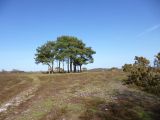
Robin Hood's Butt or Clump / Mike Faherty, 1 Apr. 2012; Creative Commons, via Geograph.
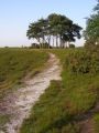
Approaching Robin Hood's Clump, Ibsley Common, New Forest / Jim Champion, 10 June 2006; Creative Commons, via Geograph.
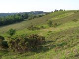
The view from Robin Hood's Butt, New Forest / Jim Champion, 10 June 2006; Creative Commons, via Geograph.

