
Robin Hood's Butt (Elford)
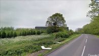
[[File:|thumb|right|500px|Elford Low, on which the large solitary tree stands, was known as 'Robin Hood's Butt' in the 19th century and earlier / Google Earth Street View]]
By Henrik Thiil Nielsen, 2020-10-28. Revised by Henrik Thiil Nielsen, 2020-10-29.
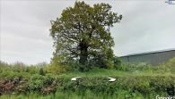
The mound now generally known as 'Elford Low', situated on the east side of Tamworth Road (A513), c. 800 m south-southeast of the village of Elford, had the alternative name of 'Robin Hood's Butt' according to local historians writing in the late 18th to mid-19th century. Another, now unidentifiable, mound situated three or four kilometres southwest of it was known under the same name. It was said, during the first half of the 19th century, that Robin Hood used to shoot arrows from one to the other. They were known collectively, therefore, as 'Robin Hood's Shooting Butts'.
Robin Hood's Butts in Elford and Wigginton were first noted by Stebbing Shaw in his History and Antiquities of Staffordshire (1798).[1] Other early local historians had no doubt that the 'butts' were Roman tumuli (see Allusions below). This may or may not have been the case; earthworks of more recent date were often misattributed to the Romans or Celts, and while the 'butt' situated southeast of Wigginton can no longer be identified, the other one, Elford Low, does not appear to be included at PastScape, which would seem to indicate that it is not currently considered archaeologically significant. However, according to William Pitt's Topographical History of Staffordshire (1817):[2]
Elford-low is situated on the top of a hill, a little beyond the paper-mill, in the corner of a fied, close to the Tamworth road, and is distinguished by an oak tree on its summit. Dr. Plott, from examination, proved it to be sepulchral. Mr. Pennant, from its elevation, conjectures that it might have had on it a specula or watch-tower; and Mr. Bourne, an intelligent farmer, who has a good house on the other side of the hill on his own estate, told Mr. Shaw that he saw the bones of three human skeletons dug out of a gravel-pit, a few years since, near this Low, which seems a conclusive proof that it is the site of some ancient cemetery.
Roman or not, it thus seems likely that Elford Low was a tumulus. C. F. Palmer (1845) felt that the tradition connecting the two mounds through Robin's shooting arrows from one to another was of fairly modern origin (see Allusions below). Template:PnItemQry
Gazetteers
- Not included in Dobson, R. B., ed.; Taylor, J., ed. Rymes of Robyn Hood: an Introduction to the English Outlaw (London, 1976), pp. 293-311.
Sources
- PastScape: Robin Hoods Butt
- Shaw, Stebbing; et al. The History and Antiquities of Staffordshire, compiled from the Manuscripts of Huntbach, Loxdale, Bishop Lyttelton, and Other Collections of Dr. Wilkes, T. Feilde, &c. &c., Including Erdeswick's Survey of the County, and the Approved Parts of Dr. Plot's Natural History (London, 1798-1801), vol. I, p. 432. Not seen but cf. PastScape, just cited.
Maps
- 25" O.S. map Staffordshire LIII.14 (c. 1883; surveyed c. 1882). No Copy in NLS
- 25" O.S. map Staffordshire LIII.14 (1901; rev. 1900) (georeferenced)
- 25" O.S. map Staffordshire LIII.14 (1901; rev. 1900)
- 25" O.S. map Staffordshire LIII.14 (1923; rev. 1921)
- 6" O.S. map Staffordshire LIII.SW (1885; surveyed 1881–82)
- 6" O.S. map Staffordshire LIII.SW (1902; rev. 1900) (georeferenced)
- 6" O.S. map Staffordshire LIII.SW (1902; rev. 1900)
- 6" O.S. map Staffordshire LIII.SW (1925; rev. 1921).
Discussion
- Wikipedia: Elford
- Tamworth Time Hikes: Robin Hood's Butt
- Tamworth Time Hikes: Robin Hood's Butt and beyond.
Notes
- ↑ Shaw, Stebbing; et al. The History and Antiquities of Staffordshire, compiled from the Manuscripts of Huntbach, Loxdale, Bishop Lyttelton, and Other Collections of Dr. Wilkes, T. Feilde, &c. &c., Including Erdeswick's Survey of the County, and the Approved Parts of Dr. Plot's Natural History (London, 1798-1801), vol. I, p. 432. Reprinted: Shaw, Stebbing; et al. The History and Antiquities of Staffordshire (Classical County Histories) (East Ardsley, 1976); neitehr seen, but cf, PastScape: Robin Hoods Butt.
- ↑ Pitt, William, compil. A Topographical History of Staffordshire: including its Agriculture, Mines and Manufactures; Statistical Tables; and every Species of Information connected with the Local History of the County. With a Succinct Account of the Rise and Progress of the Staffordshire Potteries (Newcastle-under-Lyme; Stafford; Lichfield; Wolverhampton; London, 1817), p. 132. Pitt's italics.
Elford Low was known as 'Robin Hood's Butt' in the 19th century and earlier / Google Earth Street View
Elford Low or Robin Hood's Butt / Google Earth Street View

