
Robin Hood's Bed (Blackstone Edge)

By Henrik Thiil Nielsen, 2014-09-18. Revised by Henrik Thiil Nielsen, 2019-02-11.
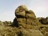
According to Dobson & Taylor, Robin Hood's Bed is a "name applied to whole or part of the prominent ridge of Blackstone Edge in the Pennines". They note that neolithic flints have been found at this site.[1] While it is true that the name is sometimes applied to the entire ridge, there is no doubt that, as noted on Northern Antiquary's informative page on this locality, what suggested the name is a rock which "overlooks the very edge of the ridge, detached from the main section, with a large and very curious nature-worn ‘bed’ on its very crown" that is c. 125 cm wide and c. 215 cm long. This "bed" has a roughly horseshoe shaped ridge. Blackstone Edge forms a border between Lancashire and Yorkshire.
"Robin Hood's Bed" is indicated twice on the 1851 6" O.S. of the area, for the specific geological feature and for the ridge on which it is found. The later 6" O.S. maps include the name for the specific feature only.
Robin Hood is supposed to have slept in the bed and to have used this lofty locality as a look-out from which he could conveniently survey the Roman road below. He also amused himself by flinging a boulder all the way to Monstone Edge, where it remains under the names of the Manstone (Man Stone) or Robin Hood's Quoit.
Paul Bennett (Northern Antiquary) also notes that the locality is mentioned in records of the township of Rishworth in 1836. A slightly older mention is found in the 1775 Allusion below.Template:PnItemQry
Gazetteers
Sources
- Farrer, William, ed.; Brownbill, J., ed. The Victoria History of the County of Lancaster (London, 1906), vol. I, p. 215; vol. V, p. 206.
- The Northern Antiquarian: Robin Hood’s Bed, Blackstone Edge, Lancashire; provides directions.
Maps
- 25" O.S. map Lancashire LXXXI.12 (c. 1910; rev. c. 1909). No Copy in NLS
- 25" O.S. map Lancashire LXXXI.12 (1893; surveyed 1891) (georeferenced)
- 25" O.S. map Lancashire LXXXI.12 (1893; surveyed 1891)
- O.S. 6" map Lancashire Sheet LXXXI (1851, surveyed 1847-48)
- O.S. 6" map Yorkshire Sheet CCXLIV.SE (1894, surveyed 1892)
- O.S. 6" map Lancashire Sheet LXXXI.SE (1895, surveyed 1890-91)
- O.S. 6" map Lancashire Sheet LXXXI.SE (1910, revised 1908-1909)
- 6" O.S. map Yorkshire CCXLIV.SE (1911; rev. 1904) (georeferenced)
- O.S. 6" map Yorkshire Sheet CCXLIV.SE (1911, revised 1904)
- O.S. 6" map Lancashire Sheet LXXXI.SE (1930, revised 1928).
Postcards
Background
Notes
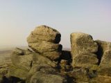
Robin Hoods Bed, looking north / The Northern Antiquary: Robin Hood’s Bed, Blackstone Edge, Lancashire.
Robin Hoods Bed, looking north / The Northern Antiquary: Robin Hood’s Bed, Blackstone Edge, Lancashire.
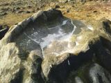
The feature that gave the site its name / The Northern Antiquary:
Robin Hood’s Bed, Blackstone Edge, Lancashire.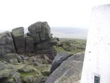
Robin Hood's Bed / John Daly.


