
Robin Hood's Arbour (Maidenhead): Difference between revisions
mNo edit summary |
mNo edit summary |
||
| Line 4: | Line 4: | ||
[[File:{{#var:Pnimage}}|thumb|right|500px|Robin Hood's Arbour / [https://twitter.com/mcc_nt/status/840124375286272004 National Trust: Maidenhead & Cookham.]]] | [[File:{{#var:Pnimage}}|thumb|right|500px|Robin Hood's Arbour / [https://twitter.com/mcc_nt/status/840124375286272004 National Trust: Maidenhead & Cookham.]]] | ||
<p id="byline">By Henrik Thiil Nielsen, 2017-12-20. Revised by {{#realname:{{REVISIONUSER}}}}, {{REVISIONYEAR}}-{{REVISIONMONTH}}-{{REVISIONDAY2}}.</p><div class="no-img"> | <p id="byline">By Henrik Thiil Nielsen, 2017-12-20. Revised by {{#realname:{{REVISIONUSER}}}}, {{REVISIONYEAR}}-{{REVISIONMONTH}}-{{REVISIONDAY2}}.</p><div class="no-img"> | ||
Robin Hood's Arbour is a square prehistoric earthwork in Maidenhead Thicket | Robin Hood's Arbour is a square prehistoric earthwork in Maidenhead Thicket, which by the late 17th century was known as 'Robin Hood's Bower', still today an alternative name for it. | ||
Bannard described the location as follows in 1931: "It is close against the private road that runs from the Henley road to Stubbings House. It is in sight of the Lodge and about 300 yards south-east of it. It is in the angle of the road to Stubbings and the grass track which crosses it, and is barely 30 yards south of the latter".<ref>{{:Bannard, H E 1931a}}; see p. 65.</ref> The site was first discussed by Charles Kerry (1861), who concluded from what he considered its "well-known features of Roman castramentation" that Robin Hood's Arbour was of Roman construction, an idea that persisted well into the 20th century.<ref>{{:Cotton, M Aylwin 1961b}}; see pp. 1-2.</ref> Mrs M. Cotton Aylwin, who made the first modern archaeological excavation of the site in 1961, describes the "arbour" as a sub-rectangular "ditched rectilinear enclosure". Its shape, which can be seen on the plan in the image gallery at the foot of this page, is not unlike that of the handle of some modern coffee cups and mugs. Its outer dimensions are approximately – clockwise from the north – 44 m, 64 m, 70 m, and 47.5 m. There is an inner bank along all sides except the southern, a ditch of variable width and depth along all sides and, except to the north, where it may however once have existed, a counterscarp bank. | |||
The earliest of the O.S. maps liste below to include the name of the "arbour" is the 25" map published 1912. | The earliest of the O.S. maps liste below to include the name of the "arbour" is the 25" map published 1912. | ||
Dobson & Taylor believed the existence of this place name | |||
==== Robbers and dancers in Maidenhead thicket ==== | |||
Dobson & Taylor believed the existence of this place-name in the late 17th cent. was the reason Thomas Hearne (see Allusions on this page) included the Chiltern Hills among Robin's haunts.<ref>{{:Dobson, Richard Barrie 1976a}}, p. 295, ''s.n.'' Robin Hood's Arbour.</ref> Conversely, it may also well have been the case that the character (and history) of this area made it seem a fit haunt for a famous robber and one where interesting localities such as the 'arbour' might well come to be named after such a character. While it was evidently safe enough for boys like the young Thomas Hearne to roam there in the lath 17th century, Maidenhead Thicket had been infested with robbers in earlier centuries. In 1255, under Henry III, an order was issued to widen the road between Maidenhead Bridge and Henley-on-Thames and cut down vegetation along it in order to make it safer for travellers. Legislation as late as the reign of Elizabeth indicates that the problem persisted. and in this period the vicar of Hurley , who also served the parish of Maidenhead, was granted an increase of salary in view of the risk he ran passing through the Thicket en route from one parish to the other.<ref>{{:Kerry, Charles 1861a}}, pp. 146-47.</ref> | |||
Revision as of 00:24, 30 May 2018
[[File:|thumb|right|500px|Robin Hood's Arbour / National Trust: Maidenhead & Cookham.]]
By Henrik Thiil Nielsen, 2017-12-20. Revised by Henrik Thiil Nielsen, 2018-05-30.
Robin Hood's Arbour is a square prehistoric earthwork in Maidenhead Thicket, which by the late 17th century was known as 'Robin Hood's Bower', still today an alternative name for it.
Bannard described the location as follows in 1931: "It is close against the private road that runs from the Henley road to Stubbings House. It is in sight of the Lodge and about 300 yards south-east of it. It is in the angle of the road to Stubbings and the grass track which crosses it, and is barely 30 yards south of the latter".[1] The site was first discussed by Charles Kerry (1861), who concluded from what he considered its "well-known features of Roman castramentation" that Robin Hood's Arbour was of Roman construction, an idea that persisted well into the 20th century.[2] Mrs M. Cotton Aylwin, who made the first modern archaeological excavation of the site in 1961, describes the "arbour" as a sub-rectangular "ditched rectilinear enclosure". Its shape, which can be seen on the plan in the image gallery at the foot of this page, is not unlike that of the handle of some modern coffee cups and mugs. Its outer dimensions are approximately – clockwise from the north – 44 m, 64 m, 70 m, and 47.5 m. There is an inner bank along all sides except the southern, a ditch of variable width and depth along all sides and, except to the north, where it may however once have existed, a counterscarp bank.
The earliest of the O.S. maps liste below to include the name of the "arbour" is the 25" map published 1912.
Robbers and dancers in Maidenhead thicket
Dobson & Taylor believed the existence of this place-name in the late 17th cent. was the reason Thomas Hearne (see Allusions on this page) included the Chiltern Hills among Robin's haunts.[3] Conversely, it may also well have been the case that the character (and history) of this area made it seem a fit haunt for a famous robber and one where interesting localities such as the 'arbour' might well come to be named after such a character. While it was evidently safe enough for boys like the young Thomas Hearne to roam there in the lath 17th century, Maidenhead Thicket had been infested with robbers in earlier centuries. In 1255, under Henry III, an order was issued to widen the road between Maidenhead Bridge and Henley-on-Thames and cut down vegetation along it in order to make it safer for travellers. Legislation as late as the reign of Elizabeth indicates that the problem persisted. and in this period the vicar of Hurley , who also served the parish of Maidenhead, was granted an increase of salary in view of the risk he ran passing through the Thicket en route from one parish to the other.[4]
"known for some unfathomable reason, as Robin Hood's Arbour, though there is no trace in record or legend of Robin Hood ever having frequented the Thicket"
Allusions
1733 - Hearne, Thomas - Note in Chronicon Prioratus de Dunstaple
[Joseph Ritson's translation:]
Certainly Silchester, in Hampshire, signifies nothing but the city of flints (that is, a city composed or built of flint-stones). [. . .] And what is more, in that very Chiltern country you may frequently see houses built of flints, in erecting which, in ancient times, I suppose that many persons involved themselves deeply in debt, and that, in order to extricate themselves, they took up money at interest of I know not what great men, which so far disturbed their minds that they would become thieves, and do many things in no wise agreeable to the English government. Hence, the nobility ordered that large woods in the Chiltern country should, in a great measure, be cut down, lest they should conceal any considerable body of robbers, who were wont to convert the same into lurking places. [. . .] It concerns this matter to call to mind, that of this sort of robbers was that Robin or Robert Hood, of whom the vulgar dayly [sic] sing so many wonderful things. He (being now made an outlaw) before he retired into the north parts, frequently robing [sic] in the Chiltern country, linked[5] [sic] in the thickets thereof on purpose that he should not be taken. Thence it was, that to us boys, (exhilarating, according to custom, the mind with sports) certain countrymen, with whom we [vol. I, p. cii n.:] had accidentally some conversation, shewed us that sort of den or retreat (vulgarly called Robin Hoods bower) in Maydenhead-thicket: which thicket is the same that Leland in his Itinerary, called Frith, by which name the Anglo-Saxons themselves spoke of thickets. For although frið in reality signifys [sic] peace, yet since numerous groves with them (as well as before with the Britons) were deemed sacred, it is by no means to be wondered at that a great wood (because manifestly an asylum) should in the judgment of the Anglo-Saxons be called by no other name than friðer: [sic] and that Maydenhead-thicket was esteemed among the greater woods Leland himself is a witness. Rightly therefor [sic] did Robin Hood (as frið-bena) reckon himself to abide there in security.[6]
Gazetteers
- Dobson, R. B., ed.; Taylor, J., ed. Rymes of Robyn Hood: an Introduction to the English Outlaw (London, 1976), p. 295, s.n. Robin Hood's Arbour.
Maps
- 25" O.S. map Berkshire XXIV.13 (c. 1876; surveyed 1874). No Copy in NLS
- 25" O.S. map Berkshire XXIV.13 (c. 1899; rev. c. 1897). No Copy in NLS]
- 25" O.S. map Berkshire XXIV.13 (1912; rev. 1910)
- 25" O.S. map Berkshire XXIV.13 (1912; rev. 1910) (georeferenced)
- 25" O.S. map Berkshire XXIV.13 (1925; rev. 1923)
- 25" O.S. map Berkshire XXIV.13 (1934; rev. 1932).
- 6" O.S. map Berkshire XXIV (1882; surveyed 1875)
- 6" O.S. map Berkshire XXIV.SW (1900; rev. 1897)
- 6" O.S. map Berkshire XXIV.SW (1900; rev. 1897) (georeferenced)
- 6" O.S. map Berkshire XXIV.SW (1913; rev. 1910)
- 6" O.S. map Berkshire XXIV.SW (1926; rev. 1923).
- 6" O.S. map Berkshire XXIV.SW (1931; rev. 1931-32)
- 6" O.S. map Berkshire XXIV.SW (c. 1944; rev. 1938)
Sources
- Gelling, Margaret. The Place-Names of Berkshire (English Place-Name Society, vols. XLIX-LI) (Cambridge, 1973; [s.l.], 1974-76), pt. I, p. 57, and see pt. I, p. 285
Discussion
- Anonymous. '[Untitled letter to the editor]', Gentleman's Magazine, vol. XXXVI (1766), p. 400.
- Cotton, M. Aylwin; [Cornwall, I.W., contrib.] 'Robin Hood's Arbour and Rectilinear Enclosures in Berkshire', Berkshire Archaeological Journal, vol. 59 (1961), pp. 1-35
- Crawford, O. G. S. 'Place-Names and Archaeology', chapter VIII in: Mawer, A.; Stenton, F.M. Introduction to the Survey of English Place-Names (English Place-Name Society, vol. I, pt. 1). (Cambridge, 1924), pp. 143-64
- Crawford, O. G. S. 'Place-Names and Archaeology', chapter VIII in: Mawer, A.; Stenton, F.M. Introduction to the Survey of English Place-Names (English Place-Name Society, vol. I, pt. 1). (Cambridge, 1925), pp. 143-64
- Crawford, O. G. S. 'Place-Names and Archaeology', chapter VIII in: Mawer, A.; Stenton, F.M. Introduction to the Survey of English Place-Names (English Place-Name Society, vol. I, pt. 1). Reprinted. (Cambridge, 1929), pp. 143-64
- Crawford, O. G. S. 'Place-Names and Archaeology', chapter VIII in: Mawer, A.; Stenton, F.M. Introduction to the Survey of English Place-Names (English Place-Name Society, vol. I, pt. 1). Reprinted. (Cambridge, 1933), pp. 143-64
- Crawford, O. G. S. 'Place-Names and Archaeology', chapter VIII in: Mawer, A.; Stenton, F.M.; Gover, J.E.B. The Place-Names of Sussex (English Place-Name Society, vols. VI-VII) (Cambridge, 1969), pp. 143-64
- Ditchfield, P H 1901a
- Ditchfield, P H 1906a, p. 204
- Kerry, Charles. The History and Antiquities of the Hundred of Bray, in the County of Berks (London, 1861), pp. 146-47, 150
- Peake, Harold. The Archaeology of Berkshire (London, [1931]), pp. 97, 190.
Background
Notes
- ↑ Bannard, H. E. 'Maidenhead Thicket', The Berkshire Archæological Journal, vol. 35, No. 1 (1931), pp. 63-80; see p. 65.
- ↑ Cotton, M Aylwin; [Cornwall, I.W., contrib.] 'Robin Hood's Arbour and Rectilinear Enclosures in Berkshire'. Reprinted from the 'Berkshire Archaeological Journal. Volume 59—Pages 1-35 (Reading, Berkshire, [c. 1961]); see pp. 1-2.
- ↑ Dobson, R. B., ed.; Taylor, J., ed. Rymes of Robyn Hood: an Introduction to the English Outlaw (London, 1976), p. 295, s.n. Robin Hood's Arbour.
- ↑ Kerry, Charles. The History and Antiquities of the Hundred of Bray, in the County of Berks (London, 1861), pp. 146-47.
- ↑ Read: lurked.
- ↑ [Morins, Richard de]; Hearne, Thomas, ed. Chronicon sive Annales Prioratus de Dunstaple (Oxford, 1733), vol. I, p. 387 n. (contd. vol. I, pp. 388 n.-389 n.); [Ritson, Joseph, ed.] Robin Hood: A Collection of All the Ancient Poems, Songs, and Ballads, now Extant, Relative to that Celebrated English Outlaw, to Which are Prefixed Historical Anecdotes of His Life (London, 1795), vol. I, p. ci n. † (contd. vol. I, p. cii n.)
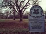
Robin Hood's Arbour / National Trust: Maidenhead & Cookham.
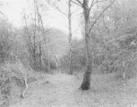
Entrance and SW corner before excavation (1961) / M. Aylwin Cotton (1961), plate I.
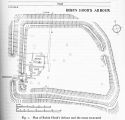
Plan of the arbour / M. Aylwin Cotton (1961), fig. 1.


