
Plumpton Park (Speke): Difference between revisions
mNo edit summary |
m (Text replacement - "|ExtraLink1=Place-names in Gest of Robyn Hode|ExtraLink2=|" to "|ExtraLink1=Place-names in Gest of Robyn Hode|ExtraLink2=Gest of Robyn Hode|") |
||
| (12 intermediate revisions by the same user not shown) | |||
| Line 1: | Line 1: | ||
__NOTOC__{{PlaceNamesItemTop|Lat=53.3405|Lon=-2.8354|AdministrativeDivision=Lancashire|Vicinity=Immediately S of Central Way; N of Dam Wood Road; northwester quarter of football field E of Little Heath Road|Type=Area|Interest=Literary locale| | __NOTOC__{{PlaceNamesItemTop|Lat=53.3405|Lon=-2.8354|AdministrativeDivision=Lancashire|Vicinity=Immediately S of Central Way; N of Dam Wood Road; northwester quarter of football field E of Little Heath Road|Type=Area|Interest=Literary locale| | ||
Status=Defunct|Demonym=|Riding=|GreaterLondon=|Year=1842|Aka=|Century=|Cluster1=|Cluster2=|Cluster3=|Image=plumpton-park-speke-google-earth-street-view.jpg|Postcards=|ExtraCat1=|ExtraCat2=|ExtraCat3=|ExtraCat4=|ExtraCat5=|ExtraLink1=|ExtraLink2=|ExtraLink3=|ExtraLink4=|ExtraLink5=|ExtraLinkName1=|ExtraLinkName2=|ExtraLinkName3=|ExtraLinkName4=|ExtraLinkName5=|GeopointPrefix=|GeopointSuffix=|VicinitySuffix=|StatusSuffix=|DatePrefix=|DateSuffix=}} | Status=Defunct|Demonym=|Riding=|GreaterLondon=|Year=1842|Aka=|Century=|Cluster1=|Cluster2=|Cluster3=|Image=plumpton-park-speke-google-earth-street-view.jpg|Postcards=|ExtraCat1=Places named Plumpton Park|ExtraCat2=|ExtraCat3=|ExtraCat4=|ExtraCat5=|ExtraLink1=Place-names in Gest of Robyn Hode|ExtraLink2=Gest of Robyn Hode|ExtraLink3=|ExtraLink4=|ExtraLink5=|ExtraLinkName1=|ExtraLinkName2=|ExtraLinkName3=|ExtraLinkName4=|ExtraLinkName5=|GeopointPrefix=|GeopointSuffix=|VicinitySuffix=|StatusSuffix=|DatePrefix=|DateSuffix=}} | ||
{{#display_map:{{#var:Coords}}~{{#replace:{{PAGENAME}}|'|'}}|width=34%|fullscreen=yes}}<div class="pnMapLegend">This area was once a barley field known as Plumpton Park.</div> | {{#display_map:{{#var:Coords}}~{{#replace:{{PAGENAME}}|'|'}}|width=34%|fullscreen=yes}}<div class="pnMapLegend">This area was once a barley field known as Plumpton Park.</div> | ||
[[File:{{#var:Image}}|thumb|right|500px|The northwestern quarter of this football field was once a barley field known as Plumpton Park / Google Earth Street View.]] | [[File:{{#var:Image}}|thumb|right|500px|The northwestern quarter of this football field was once a barley field known as Plumpton Park / Google Earth Street View.]] | ||
| Line 8: | Line 8: | ||
'Plumpton Park' is also the name in the [[Gest of Robyn Hode]] of an area in Wyresdale, where King Edward discovers to his chagrin that Robin Hood has severely depleted the stock of deer. This Plumpton Park is thus not identical with that in Speke, but since various other localities than that in Wyresdale have been suggested as the intended locale, IRHB considers it of some interest to compile as full a list as possible of localities with this name. | 'Plumpton Park' is also the name in the [[Gest of Robyn Hode]] of an area in Wyresdale, where King Edward discovers to his chagrin that Robin Hood has severely depleted the stock of deer. This Plumpton Park is thus not identical with that in Speke, but since various other localities than that in Wyresdale have been suggested as the intended locale, IRHB considers it of some interest to compile as full a list as possible of localities with this name. | ||
The field name occurs in the 1842 tithe award for the 'Township of Speke in the Parish of Childwall', where the landowner is recorded as Richard Watt, Esq., the occupier as William Atherton, Jr., its area as 2 acres, 2 roods and 30 perches ({{AcresRoodsPerchesToM2|2|2|30}} m<sup>2</sup>), and the state of cultivation as barley.<ref>1842 tithe award for the 'Township of Speke in the Parish of Childwall', online at the [https://www.thegenealogist.com Genealogist], | The field name occurs in the 1842 tithe award for the 'Township of Speke in the Parish of Childwall', where the landowner is recorded as Richard Watt, Esq., the occupier as William Atherton, Jr., its area as 2 acres, 2 roods and 30 perches ({{AcresRoodsPerchesToM2|2|2|30}} m<sup>2</sup>), and the state of cultivation as barley.<ref>1842 tithe award for the 'Township of Speke in the Parish of Childwall', online at the [https://www.thegenealogist.com Genealogist], Piece 18, sub-piece 291, Image 010 (£); accompanying map, online at the [https://www.thegenealogist.com Genealogist], Piece 18, sub-piece 291, Sub-Image 001 (£).</ref> | ||
To get some idea of the size, location and shape of the area in Speke then known as Plumpton Park, imagine that the northwestern quarter of the football grounds bounded by Central Way, Oldbridge Road, Dam Wood Road, and Little Heath Road were turned ''c.'' 45° clockwise around its centre point. The contours of the field are indicated only on the earliest (1849) of the 6" O.S. maps of the area listed below. See the adapted map detail in the image gallery below, where the field is coloured maroon. | To get some idea of the size, location and shape of the area in Speke then known as Plumpton Park, imagine that the northwestern quarter of the football grounds bounded by Central Way, Oldbridge Road, Dam Wood Road, and Little Heath Road were turned ''c.'' 45° clockwise around its centre point. The contours of the field are indicated only on the earliest (1849) of the 6" O.S. maps of the area listed below. See the adapted map detail in the image gallery below, where the field is coloured maroon. | ||
| Line 15: | Line 15: | ||
* Not included in {{:Dobson, Richard Barrie 1976a}}, pp. 293-311. | * Not included in {{:Dobson, Richard Barrie 1976a}}, pp. 293-311. | ||
== MS sources == | == MS sources == | ||
* 1842 tithe award for the 'Township of Speke in the Parish of Childwall', online at the [https://www.thegenealogist.com Genealogist], | * 1842 tithe award for the 'Township of Speke in the Parish of Childwall', online at the [https://www.thegenealogist.com Genealogist], Piece 18, sub-piece 291, Image 010 (£) | ||
* accompanying map, online at the [https://www.thegenealogist.com Genealogist], | * accompanying map, online at the [https://www.thegenealogist.com Genealogist], Piece 18, sub-piece 291, Sub-Image 001 (£). | ||
== Maps == | == Maps == | ||
* 25" O.S: map ''Lancashire'' CXIV.14 (''c.'' 1893; ''c.'' 1891). No | * 25" O.S: map ''Lancashire'' CXIV.14 (''c.'' 1893; ''c.'' 1891). No copy in NLS | ||
* [https://maps.nls.uk/geo/explore/#zoom=16&lat=53.34025&lon=-2.83561&layers=168&b=5 25" O.S. map ''Lancashire'' CII.5 (1907; rev. 1905)] (georeferenced) | * [https://maps.nls.uk/geo/explore/#zoom=16&lat=53.34025&lon=-2.83561&layers=168&b=5 25" O.S. map ''Lancashire'' CII.5 (1907; rev. 1905)] (georeferenced) | ||
* [https://maps.nls.uk/view/126524165#zoom=5&lat=2203&lon=7266&layers=BT 25" O.S. map ''Lancashire'' CXIV.14 (1907; rev. 1904)] | * [https://maps.nls.uk/view/126524165#zoom=5&lat=2203&lon=7266&layers=BT 25" O.S. map ''Lancashire'' CXIV.14 (1907; rev. 1904)] | ||
| Line 48: | Line 48: | ||
<gallery widths="195px"> | <gallery widths="195px"> | ||
plumpton-park-speke-google-earth-street-view.jpg|The northwestern quarter of this football field was once a barley field known as Plumpton Park / Google Earth Street View. | plumpton-park-speke-google-earth-street-view.jpg|The northwestern quarter of this football field was once a barley field known as Plumpton Park / Google Earth Street View. | ||
plumpton-park-speke-NLS.jpg|Plumpton Park indicated in maroon / Detail of [https://maps.nls.uk/view/102344126#zoom=6&lat=962&lon=5504&layers=BT 6" O.S. map ''Lancashire'' CXIV (1849; surveyed 1845–46);] reprod. with perm. of [https://maps.nls.uk NLS]; under [https://maps.nls.uk/copyright.html#exceptions Creative Commons Attrib. (CC-BY) license;] adapt. Henrik Thiil Nielsen. | |||
</gallery> | </gallery> | ||
{{PlaceNamesItemNavigation}} | {{PlaceNamesItemNavigation}} | ||
Latest revision as of 17:32, 17 May 2022
| Locality | |
|---|---|
| Coordinate | 53.3405, -2.8354 |
| Adm. div. | Lancashire |
| Vicinity | Immediately S of Central Way; N of Dam Wood Road; northwester quarter of football field E of Little Heath Road |
| Type | Area |
| Interest | Literary locale |
| Status | Defunct |
| First Record | 1842 |

By Henrik Thiil Nielsen, 2021-01-23. Revised by Henrik Thiil Nielsen, 2022-05-17.
In 1842, a barley field in Speke, now a suburb of Liverpool, was known as Plumpton Park. In modern terms it was situated immediately south of Central Way and north of Dam Wood Road.
'Plumpton Park' is also the name in the Gest of Robyn Hode of an area in Wyresdale, where King Edward discovers to his chagrin that Robin Hood has severely depleted the stock of deer. This Plumpton Park is thus not identical with that in Speke, but since various other localities than that in Wyresdale have been suggested as the intended locale, IRHB considers it of some interest to compile as full a list as possible of localities with this name.
The field name occurs in the 1842 tithe award for the 'Township of Speke in the Parish of Childwall', where the landowner is recorded as Richard Watt, Esq., the occupier as William Atherton, Jr., its area as 2 acres, 2 roods and 30 perches (10875.93 m2), and the state of cultivation as barley.[1]
To get some idea of the size, location and shape of the area in Speke then known as Plumpton Park, imagine that the northwestern quarter of the football grounds bounded by Central Way, Oldbridge Road, Dam Wood Road, and Little Heath Road were turned c. 45° clockwise around its centre point. The contours of the field are indicated only on the earliest (1849) of the 6" O.S. maps of the area listed below. See the adapted map detail in the image gallery below, where the field is coloured maroon.
Gazetteers
- Not included in Dobson, R. B., ed.; Taylor, J., ed. Rymes of Robyn Hood: an Introduction to the English Outlaw (London, 1976), pp. 293-311.
MS sources
- 1842 tithe award for the 'Township of Speke in the Parish of Childwall', online at the Genealogist, Piece 18, sub-piece 291, Image 010 (£)
- accompanying map, online at the Genealogist, Piece 18, sub-piece 291, Sub-Image 001 (£).
Maps
- 25" O.S: map Lancashire CXIV.14 (c. 1893; c. 1891). No copy in NLS
- 25" O.S. map Lancashire CII.5 (1907; rev. 1905) (georeferenced)
- 25" O.S. map Lancashire CXIV.14 (1907; rev. 1904)
- 25" O.S. map Lancashire CXIV.14 (1927; rev. 1925)
- 25" O.S. map Lancashire CXIV.14 (1938; rev. 1936)
- 6" O.S. map Lancashire CXIV (1849; surveyed 1845–46)
- 6" O.S. map Lancashire CXIV.SW (1894; surveyed 1890–91)
- 6" O.S. map Lancashire CXIV.SW (1908; rev. 1904) (georeferenced)
- 6" O.S. map Lancashire CXIV.SW (1908; rev. 1904)
- 6" O.S. map Lancashire CXIV.SW (c. 1935; rev. 1925)
- 6" O.S. map Lancashire CXIV.SW (1944; rev. 1938)
- 6" O.S. map Lancashire CXIV.SW (1947; rev. 1938).
Also see
Notes
- ↑ 1842 tithe award for the 'Township of Speke in the Parish of Childwall', online at the Genealogist, Piece 18, sub-piece 291, Image 010 (£); accompanying map, online at the Genealogist, Piece 18, sub-piece 291, Sub-Image 001 (£).
Image gallery
Click any image to display it in the lightbox, where you can navigate between images by clicking in the right or left side of the current image.
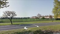
The northwestern quarter of this football field was once a barley field known as Plumpton Park / Google Earth Street View.
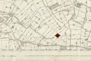
Plumpton Park indicated in maroon / Detail of 6" O.S. map Lancashire CXIV (1849; surveyed 1845–46); reprod. with perm. of NLS; under Creative Commons Attrib. (CC-BY) license; adapt. Henrik Thiil Nielsen.
