
Plumpton Park (Middleton by Wirksworth): Difference between revisions
m (Text replacement - "<h3>Allusions</h3>" to "<h2>Allusions</h2>") |
m (Text replacement - "|ExtraLink1=Place-names in Gest of Robyn Hode|ExtraLink2=|" to "|ExtraLink1=Place-names in Gest of Robyn Hode|ExtraLink2=Gest of Robyn Hode|") |
||
| (32 intermediate revisions by the same user not shown) | |||
| Line 1: | Line 1: | ||
__NOTOC__{{ | __NOTOC__{{PlaceNamesItemTop|Lat=53.1004|Lon=-1.5917|AdministrativeDivision=Derbyshire|Vicinity=Middleton by Wirksworth|Type=Area|Interest=Literary locale|Status=Defunct|Demonym=|Riding=|GreaterLondon=|Year=1500|Aka=|Century=|Cluster1=|Cluster2=|Cluster3=|Image=geograph-2995848-by-Chris-Wimbush.jpg|Postcards=|ExtraCat1=Places named Plumpton Park|ExtraCat2=|ExtraCat3=|ExtraCat4=|ExtraCat5=|ExtraLink1=Place-names in Gest of Robyn Hode|ExtraLink2=Gest of Robyn Hode|ExtraLink3=|ExtraLink4=|ExtraLink5=|ExtraLinkName1=|ExtraLinkName2=|ExtraLinkName3=|ExtraLinkName4=|ExtraLinkName5=|GeopointPrefix=|GeopointSuffix=|StatusSuffix=?|DatePrefix=''c. ''|DateSuffix=}} | ||
{{#display_map:{{#var:Coords}}~{{#replace:{{PAGENAME}}|'|'}}|width=34%}}<div class="pnMapLegend">Middleton by Wirksworth, in whose vicinity was situated a field called Plumpton Park<br/> according to an 1841 Enclosure Award.</div> | {{#display_map:{{#var:Coords}}~{{#replace:{{PAGENAME}}|'|'}}|width=34%|enablefullscreen=yes}}<div class="pnMapLegend">Middleton by Wirksworth, in whose vicinity was situated a field called Plumpton Park<br/> according to an 1841 Enclosure Award.</div> | ||
[[File:{{#var:Image}}|thumb|right|500px|Middleton seen from a point on the Moor in or near the former Plumpton Park / [https://m.geograph.org.uk/photo/2995848 Chris Wimbush, 16 June 2012; Creative Commons, via Geograph.]]] | |||
<div class="no-img"> | |||
<p id="byline">By Henrik Thiil Nielsen, 2016-08-19. Revised by {{#realname:{{REVISIONUSER}}}}, {{REVISIONYEAR}}-{{REVISIONMONTH}}-{{REVISIONDAY2}}.</p> | <p id="byline">By Henrik Thiil Nielsen, 2016-08-19. Revised by {{#realname:{{REVISIONUSER}}}}, {{REVISIONYEAR}}-{{REVISIONMONTH}}-{{REVISIONDAY2}}.</p> | ||
In the ''[[Gest of Robyn Hode|Gest]]'', King Edward is exasperated at noticing the scarcity of deer in Plumpton Park after Robin and his men have been poaching there during their stay with the knight. We should almost certainly take this to be in Lancashire, but it is perhaps worth noting that Plumpton Park occurs as a field name in Middleton by Wirksworth, Derbyshire, in 1841. | |||
In the ''[[Gest of Robyn Hode|Gest]]'', King Edward is exasperated at noticing the scarcity of deer in Plumpton Park after Robin and his men have been poaching there during their stay with the knight. We should almost certainly take this to be in Lancashire, but it is perhaps worth noting that Plumpton Park occurs as a field name in Middleton by Wirksworth, Derbyshire. The source is an | |||
{{ | The source is the tithe award for the 'Township of Middleton by Wirksworth in the Parish of Wirksworth' (1841), in which Plumpton Park figures with Gell Philips, executors of Edward Sacheverll [''sic''] Chandos Pole, Esq., and John Cruse, Esq., as landowners, Samuel Brooks, sen., as occupier, 'Meadow' as state of cultivation, and an area of 1 rood and 22 perches ({{AcresRoodsPerchesToM2|0|1|22}} m<sup>2</sup>).<ref>1841 tithe award for the 'Township of Middleton by Wirksworth in the Parish of Wirksworth', online at the [https://www.thegenealogist.com Genealogist], Piece 08, sub-piece 147, Image 018, #637 (£); accompanying map, online at the [https://www.thegenealogist.com Genealogist], Piece 08, sub-piece 147, Sub-Image 001, #637 (£); also see {{:Cameron, Kenneth 1959a}}, pt. II (1959), p. 398.</ref> As is usually the case with field-names, this Plumpton Park is not found on the 6" O.S. maps of the area (see maps listed in Maps section below), but it is easily located on the basis of the tithe map. The former Plumpton Park is now the part of the Moor just behind the row of houses on the western side of the street named the Moor. The area is indicated in maroon on the adapted O.S. map included in the image gallery below. | ||
== | {{PlaceNamesItemAllusionsAndRecords}} | ||
* | == Quotations == | ||
* | {{quote|[''Gest''; ''c.'' 1500:]<br/> | ||
All the passe of Lancasshyre<br/> | |||
* [ | He went both ferre and nere<br/> | ||
Tyll he came to Plomton Parke<br/> | |||
He faylyd many of his dere.<ref>''[[Gest of Robyn Hode|Gest]]'', st. 357.</ref>}} | |||
== Gazetteers == | |||
* Not included in {{:Dobson, Richard Barrie 1976a}}, pp. 293-311. | |||
== MS sources == | |||
* 1841 tithe award for the 'Township of Middleton by Wirksworth in the Parish of Wirksworth', online at the [https://www.thegenealogist.com Genealogist], Piece 08, sub-piece 147, Image 018, #637 (£) | |||
* accompanying map, online at the [https://www.thegenealogist.com Genealogist], Piece 08, sub-piece 147, Sub-Image 001, #637 (£). | |||
== | == Printed sources == | ||
* {{:Cameron, Kenneth 1959a}}, pt. II (1959), p. 398. | * {{:Cameron, Kenneth 1959a}}, pt. II (1959), p. 398. | ||
{{ | == Maps == | ||
* 25" O.S. map ''Derbyshire'' XXXIV.10 (''c.'' 1880; surveyed ''c.'' 1879). No copy in NLS] | |||
* [https://maps.nls.uk/geo/explore/#zoom=17&lat=53.10025&lon=-1.59214&layers=168&b=5 25" O.S. map ''Derbyshire'' XXXIV.10 (1899; rev. 1898)] (georeferenced) | |||
* [https://maps.nls.uk/view/114588722#zoom=6&lat=5103&lon=1909&layers=BT 25" O.S. map ''Derbyshire'' XXXIV.10 (1899; rev. 1898)] | |||
* [https://maps.nls.uk/view/114588725#zoom=5&lat=4773&lon=1719&layers=BT 25" O.S. map ''Derbyshire'' XXXIV.10 (1922; rev. 1920)] | |||
* [https://maps.nls.uk/view/101601057#zoom=6&lat=4476&lon=4987&layers=BT 6" O.S. map ''Derbyshire'' XXXIV.SW (1884; surveyed 1879)] | |||
* [https://maps.nls.uk/geo/explore/#zoom=17&lat=53.10043&lon=-1.59273&layers=6&b=5 6" O.S. map ''Derbyshire'' XXXIV.SW (1900; rev. 1898)] (georeferenced) | |||
* [https://maps.nls.uk/view/101601054#zoom=5&lat=4338&lon=4536&layers=BT 6" O.S. map ''Derbyshire'' XXXIV.SW (1900; rev. 1898)] | |||
* [https://maps.nls.uk/view/102341358#zoom=6&lat=4596&lon=4584&layers=BT 6" O.S. map ''Derbyshire'' XXXIV (1924; rev. 1920)] | |||
* [https://maps.nls.uk/view/101601051#zoom=5&lat=4648&lon=4755&layers=BT 6" O.S. map ''Derbyshire'' XXXIV.SW (1924; rev. 1920)] | |||
* [https://maps.nls.uk/view/101601048#zoom=5&lat=4454&lon=4749&layers=BT 6" O.S. map ''Derbyshire'' XXXIV.SW (''c.'' 1948; rev. 1938).] | |||
{{PlaceNamesItemAlsoSee}} | |||
== Notes == | == Notes == | ||
| Line 22: | Line 43: | ||
</div> | </div> | ||
{{ImageGalleryIntroduction}} | |||
<gallery widths="195px"> | |||
geograph-2995848-by-Chris-Wimbush.jpg|Middleton seen from a point on the Moor in or near the former Plumpton Park / [https://m.geograph.org.uk/photo/2995848 Chris Wimbush, 16 June 2012; Creative Commons, via Geograph.] | |||
plumpton-park-middleton-by-wirksworth-google-earth.jpg|The former Plumpton Park is situated immediately west of the houses on the west side of the street named The Moor / Google Earth. | |||
plumpton-park-middleton-by-wirksworth-nls.jpg|Plumpton Park indicated in maroon / Detail of [https://maps.nls.uk/view/101601054#zoom=5&lat=4440&lon=4591&layers=BT 6" O.S. map ''Derbyshire'' XXXIV.SW (1900; rev. 1898);] reprod. with perm. of [https://maps.nls.uk NLS]; under [https://maps.nls.uk/copyright.html#exceptions Creative Commons Attrib. (CC-BY) license;] adapt. Henrik Thiil Nielsen. | |||
</gallery> | |||
{{ | {{PlaceNamesItemNavigation}} | ||
Latest revision as of 17:32, 17 May 2022
| Locality | |
|---|---|
| Coordinate | 53.1004, -1.5917 |
| Adm. div. | Derbyshire |
| Vicinity | Middleton by Wirksworth |
| Type | Area |
| Interest | Literary locale |
| Status | Defunct? |
| First Record | c. 1500 |
according to an 1841 Enclosure Award.

By Henrik Thiil Nielsen, 2016-08-19. Revised by Henrik Thiil Nielsen, 2022-05-17.
In the Gest, King Edward is exasperated at noticing the scarcity of deer in Plumpton Park after Robin and his men have been poaching there during their stay with the knight. We should almost certainly take this to be in Lancashire, but it is perhaps worth noting that Plumpton Park occurs as a field name in Middleton by Wirksworth, Derbyshire, in 1841.
The source is the tithe award for the 'Township of Middleton by Wirksworth in the Parish of Wirksworth' (1841), in which Plumpton Park figures with Gell Philips, executors of Edward Sacheverll [sic] Chandos Pole, Esq., and John Cruse, Esq., as landowners, Samuel Brooks, sen., as occupier, 'Meadow' as state of cultivation, and an area of 1 rood and 22 perches (1568.16 m2).[1] As is usually the case with field-names, this Plumpton Park is not found on the 6" O.S. maps of the area (see maps listed in Maps section below), but it is easily located on the basis of the tithe map. The former Plumpton Park is now the part of the Moor just behind the row of houses on the western side of the street named the Moor. The area is indicated in maroon on the adapted O.S. map included in the image gallery below.
Quotations
[Gest; c. 1500:]
All the passe of Lancasshyre
He went both ferre and nere
Tyll he came to Plomton Parke
He faylyd many of his dere.[2]
Gazetteers
- Not included in Dobson, R. B., ed.; Taylor, J., ed. Rymes of Robyn Hood: an Introduction to the English Outlaw (London, 1976), pp. 293-311.
MS sources
- 1841 tithe award for the 'Township of Middleton by Wirksworth in the Parish of Wirksworth', online at the Genealogist, Piece 08, sub-piece 147, Image 018, #637 (£)
- accompanying map, online at the Genealogist, Piece 08, sub-piece 147, Sub-Image 001, #637 (£).
Printed sources
- Cameron, Kenneth. The Place-Names of Derbyshire (English Place-Name Society, vols. XXVII-XXIX) (Cambridge, 1959), pt. II (1959), p. 398.
Maps
- 25" O.S. map Derbyshire XXXIV.10 (c. 1880; surveyed c. 1879). No copy in NLS]
- 25" O.S. map Derbyshire XXXIV.10 (1899; rev. 1898) (georeferenced)
- 25" O.S. map Derbyshire XXXIV.10 (1899; rev. 1898)
- 25" O.S. map Derbyshire XXXIV.10 (1922; rev. 1920)
- 6" O.S. map Derbyshire XXXIV.SW (1884; surveyed 1879)
- 6" O.S. map Derbyshire XXXIV.SW (1900; rev. 1898) (georeferenced)
- 6" O.S. map Derbyshire XXXIV.SW (1900; rev. 1898)
- 6" O.S. map Derbyshire XXXIV (1924; rev. 1920)
- 6" O.S. map Derbyshire XXXIV.SW (1924; rev. 1920)
- 6" O.S. map Derbyshire XXXIV.SW (c. 1948; rev. 1938).
Also see
Notes
- ↑ 1841 tithe award for the 'Township of Middleton by Wirksworth in the Parish of Wirksworth', online at the Genealogist, Piece 08, sub-piece 147, Image 018, #637 (£); accompanying map, online at the Genealogist, Piece 08, sub-piece 147, Sub-Image 001, #637 (£); also see Cameron, Kenneth. The Place-Names of Derbyshire (English Place-Name Society, vols. XXVII-XXIX) (Cambridge, 1959), pt. II (1959), p. 398.
- ↑ Gest, st. 357.
Image gallery
Click any image to display it in the lightbox, where you can navigate between images by clicking in the right or left side of the current image.

Middleton seen from a point on the Moor in or near the former Plumpton Park / Chris Wimbush, 16 June 2012; Creative Commons, via Geograph.
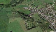
The former Plumpton Park is situated immediately west of the houses on the west side of the street named The Moor / Google Earth.
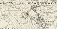
Plumpton Park indicated in maroon / Detail of 6" O.S. map Derbyshire XXXIV.SW (1900; rev. 1898); reprod. with perm. of NLS; under Creative Commons Attrib. (CC-BY) license; adapt. Henrik Thiil Nielsen.

