
Plumpton Park (Kirkbymoorside): Difference between revisions
mNo edit summary |
mNo edit summary |
||
| (16 intermediate revisions by the same user not shown) | |||
| Line 1: | Line 1: | ||
__NOTOC__{{ | __NOTOC__{{PlaceNamesItemTop|Lat=54.2756|Lon=-0.9391|AdministrativeDivision=Yorkshire|Vicinity=E side of Gillamoor Road, ''c.'' 100 m NNW of Keld Head Road; N outskirts of Kirkbymoorside|Type=Area|Interest=Literary locale| | ||
Status=Defunct|Demonym=|Riding=North|GreaterLondon=|Year=1847|Aka=|Century=|Cluster1=|Cluster2=|Cluster3=|Image=plumpton-park-kirkbymoorside-google-earth-street-view.jpg|Postcards=|ExtraCat1=Places named Plumpton Park|ExtraCat2=|ExtraCat3=|ExtraCat4=|ExtraCat5=|ExtraLink1=|ExtraLink2=|ExtraLink3=|ExtraLink4=|ExtraLink5=|ExtraLinkName1=|ExtraLinkName2=|ExtraLinkName3=|ExtraLinkName4=|ExtraLinkName5=|GeopointPrefix=|GeopointSuffix=|VicinitySuffix=|StatusSuffix=|DatePrefix=|DateSuffix=}} | Status=Defunct|Demonym=|Riding=North|GreaterLondon=|Year=1847|Aka=|Century=|Cluster1=|Cluster2=|Cluster3=|Image=plumpton-park-kirkbymoorside-google-earth-street-view.jpg|Postcards=|ExtraCat1=Places named Plumpton Park|ExtraCat2=|ExtraCat3=|ExtraCat4=|ExtraCat5=|ExtraLink1=Place-names in Gest of Robyn Hode|ExtraLink2=Gest of Robyn Hode|ExtraLink3=|ExtraLink4=|ExtraLink5=|ExtraLinkName1=|ExtraLinkName2=|ExtraLinkName3=|ExtraLinkName4=|ExtraLinkName5=|GeopointPrefix=|GeopointSuffix=|VicinitySuffix=|StatusSuffix=|DatePrefix=|DateSuffix=}} | ||
{{#display_map:{{#var:Coords}}~{{#replace:{{PAGENAME}}|'|'}}|width=34%}}<div class="pnMapLegend">The former Plumpton Park.</div> | {{#display_map:{{#var:Coords}}~{{#replace:{{PAGENAME}}|'|'}}|width=34%|fullscreen=yes}}<div class="pnMapLegend">The former Plumpton Park.</div> | ||
[[File:{{#var: | [[File:{{#var:Image}}|thumb|right|500px|These homes on Gillamoor Road sit in the former Plumpton Park / Google Earth Street View.]] | ||
[[File:plumpton-park-kirkbymoorside-nls-os.jpg|thumb|right|500px|The gray area approximately indicates | [[File:plumpton-park-kirkbymoorside-nls-os.jpg|thumb|right|500px|The small gray area near the centre approximately indicates the size, shape and location of Plumpton Park in 1847 / [https://maps.nls.uk/copyright.html#exceptions Reproduced with the permission of the National Library of Scotland; Creative Commons.] Adapted by Henrik Thiil Nielsen.]] | ||
<p id="byline">By Henrik Thiil Nielsen, 2020-08-28. Revised by {{#realname:{{REVISIONUSER}}}}, {{REVISIONYEAR}}-{{REVISIONMONTH}}-{{REVISIONDAY2}}.</p><div class="no-img"> | <p id="byline">By Henrik Thiil Nielsen, 2020-08-28. Revised by {{#realname:{{REVISIONUSER}}}}, {{REVISIONYEAR}}-{{REVISIONMONTH}}-{{REVISIONDAY2}}.</p><div class="no-img"> | ||
In the ''[[Gest of Robyn Hode|Gest]]'', King Edward is exasperated at noticing the scarcity of deer in Plumpton Park after Robin and his men have been poaching there during their stay with the knight. We should almost certainly take this to be in Lancashire, but it is perhaps worth noting that Plumpton Park occurs as a field name in Kirkbymoorside, North Yorkshire, formerly the North Riding of Yorkshire. The source is an 1847 tithe award. In present-day terms. the site is situated on the east side of Gillamoor Road, ''c.'' 100 m NNW of Keld Head Road, in the northern outskirts of Kirkbymoorside. | In the ''[[Gest of Robyn Hode|Gest]]'', King Edward is exasperated at noticing the scarcity of deer in Plumpton Park after Robin and his men have been poaching there during their stay with the knight. We should almost certainly take this to be in Lancashire, but it is perhaps worth noting that Plumpton Park occurs as a field name in Kirkbymoorside, North Yorkshire, formerly the North Riding of Yorkshire. The source is an 1847 tithe award. In present-day terms. the site is situated on the east side of Gillamoor Road, ''c.'' 100 m NNW of Keld Head Road, in the northern outskirts of Kirkbymoorside. | ||
In the tithe award for the township of Kirkbymoorside in the parish of Kirkbymoorside, drawn up in 1847, Plumpton Park is listed as arable land with an area of 7 perches ({{ | In the tithe award for the township of Kirkbymoorside in the parish of Kirkbymoorside, drawn up in 1847, Plumpton Park is listed as arable land with an area of 7 perches ({{AcresRoodsPerchesToM2|0|0|7}} m<sup>2</sup>). Its owner/occupier was a John Richardson, shoemaker.<ref>[https://www.thegenealogist.com The Genealogist], Piece 042, Sub-Piece 208, Sub-Image 167, Plot 578; 1847 Kirkbymoorside tithe award; [https://www.thegenealogist.com The Genealogist], Piece 042, Sub-Piece 208, Sub-Image 001, colour, Plot 578; 1838 Kirkbymoorside tithe award map (£).</ref> | ||
{{ | {{PlaceNamesItemAllusionsAndRecords}} | ||
== Quotations == | == Quotations == | ||
{{quote|[''Gest''; ''c.'' 1500:]<br/> | {{quote|[''Gest''; ''c.'' 1500:]<br/> | ||
| Line 15: | Line 15: | ||
Tyll he came to Plomton Parke<br/> | Tyll he came to Plomton Parke<br/> | ||
He faylyd many of his dere.<ref>''[[Gest of Robyn Hode|Gest]]'', st. 357.</ref>}} | He faylyd many of his dere.<ref>''[[Gest of Robyn Hode|Gest]]'', st. 357.</ref>}} | ||
{{ | {{PlaceNamesItemAllusionsAndRecords}} | ||
== Gazetteers == | == Gazetteers == | ||
* Not included in {{:Dobson, Richard Barrie 1976a}}, pp. 293-311. | * Not included in {{:Dobson, Richard Barrie 1976a}}, pp. 293-311. | ||
== Sources == | == Sources == | ||
* [https://www.thegenealogist.com The Genealogist], Piece 042, Sub-Piece 208, Sub-Image 167, Plot 578; 1847 Kirkbymoorside tithe award ( | * [https://www.thegenealogist.com The Genealogist], Piece 042, Sub-Piece 208, Sub-Image 167, Plot 578; 1847 Kirkbymoorside tithe award (£) | ||
* [https://www.thegenealogist.com The Genealogist], Piece 042, Sub-Piece 208, Sub-Image 001, colour, Plot 578; 1847 Kirkbymoorside tithe award map ( | * [https://www.thegenealogist.com The Genealogist], Piece 042, Sub-Piece 208, Sub-Image 001, colour, Plot 578; 1847 Kirkbymoorside tithe award map (£). | ||
== Maps == | == Maps == | ||
| Line 29: | Line 29: | ||
* [https://maps.nls.uk/view/102344407#zoom=5&lat=866&lon=6403&layers=BT 6" O.S. map ''Yorkshire'' 74 (1856; surveyed 1848–53)] | * [https://maps.nls.uk/view/102344407#zoom=5&lat=866&lon=6403&layers=BT 6" O.S. map ''Yorkshire'' 74 (1856; surveyed 1848–53)] | ||
* [https://maps.nls.uk/view/100943366#zoom=4&lat=1547&lon=7302&layers=BT 6" O.S. map ''Yorkshire'' LXXIV.SW (1895; surveyed 1891).] | * [https://maps.nls.uk/view/100943366#zoom=4&lat=1547&lon=7302&layers=BT 6" O.S. map ''Yorkshire'' LXXIV.SW (1895; surveyed 1891).] | ||
* 6" O.S. map ''Yorkshire'' LXXIV (1895; surveyed 1893). Not online | |||
* [https://maps.nls.uk/geo/explore/#zoom=16&lat=54.27573&lon=-0.94190&layers=6&b=5 6" O.S. map ''Yorkshire'' LXXIV.SW (1914; rev. 1910)] (georeferenced) | * [https://maps.nls.uk/geo/explore/#zoom=16&lat=54.27573&lon=-0.94190&layers=6&b=5 6" O.S. map ''Yorkshire'' LXXIV.SW (1914; rev. 1910)] (georeferenced) | ||
* [https://maps.nls.uk/view/100943363#zoom=5&lat=1542&lon=7170&layers=BT 6" O.S. map ''Yorkshire'' LXXIV.SW (1914; rev. 1910).] | * [https://maps.nls.uk/view/100943363#zoom=5&lat=1542&lon=7170&layers=BT 6" O.S. map ''Yorkshire'' LXXIV.SW (1914; rev. 1910).] | ||
| Line 38: | Line 39: | ||
<!--== Brief mention == | <!--== Brief mention == | ||
* --> | * --> | ||
{{ | {{PlaceNamesItemAlsoSee}} | ||
== Notes == | == Notes == | ||
| Line 45: | Line 46: | ||
</div> | </div> | ||
{{ | {{ImageGalleryIntroduction}} | ||
<gallery widths="195px"> | <gallery widths="195px"> | ||
plumpton-park-kirkbymoorside-google-earth-street-view.jpg|These homes on Gillamoor Road sit in the former Plumpton Park / Google Earth Street View. | plumpton-park-kirkbymoorside-google-earth-street-view.jpg|These homes on Gillamoor Road sit in the former Plumpton Park / Google Earth Street View. | ||
geograph-3250766-by-T--Eyre.jpg|'Snow in Manor Vale'; photo taken immediately north of the former Plumpton Park / [https://m.geograph.org.uk/photo/3250766 T. Eyre, 5 Feb. 2012, Creative Commons, via Geograph.] | geograph-3250766-by-T--Eyre.jpg|'Snow in Manor Vale'; photo taken immediately north of the former Plumpton Park / [https://m.geograph.org.uk/photo/3250766 T. Eyre, 5 Feb. 2012, Creative Commons, via Geograph.] | ||
geograph-2350277-by-Pauline-E.jpg|'Path into Spring Wood'; this area was part of or adjacent to Plumpton Park / [https://m.geograph.org.uk/photo/2350277 Pauline E., 10 Apr. 2011, Creative Commons, via Geograph.] | geograph-2350277-by-Pauline-E.jpg|'Path into Spring Wood'; this area was part of or adjacent to Plumpton Park / [https://m.geograph.org.uk/photo/2350277 Pauline E., 10 Apr. 2011, Creative Commons, via Geograph.] | ||
plumpton-park-kirkbymoorside-nls-os.jpg|The gray area approximately indicates | plumpton-park-kirkbymoorside-nls-os.jpg|The small gray area near the centre approximately indicates the size, shape and location of Plumpton Park in 1847 / [https://maps.nls.uk/copyright.html#exceptions Reproduced with the permission of the National Library of Scotland; Creative Commons.] Adapted by Henrik Thiil Nielsen. | ||
</gallery> | </gallery> | ||
{{ | {{PlaceNamesItemNavigation}} | ||
Latest revision as of 17:39, 17 May 2022
| Locality | |
|---|---|
| Coordinate | 54.2756, -0.9391 |
| Adm. div. | North Riding of Yorkshire |
| Vicinity | E side of Gillamoor Road, c. 100 m NNW of Keld Head Road; N outskirts of Kirkbymoorside |
| Type | Area |
| Interest | Literary locale |
| Status | Defunct |
| First Record | 1847 |


By Henrik Thiil Nielsen, 2020-08-28. Revised by Henrik Thiil Nielsen, 2022-05-17.
In the Gest, King Edward is exasperated at noticing the scarcity of deer in Plumpton Park after Robin and his men have been poaching there during their stay with the knight. We should almost certainly take this to be in Lancashire, but it is perhaps worth noting that Plumpton Park occurs as a field name in Kirkbymoorside, North Yorkshire, formerly the North Riding of Yorkshire. The source is an 1847 tithe award. In present-day terms. the site is situated on the east side of Gillamoor Road, c. 100 m NNW of Keld Head Road, in the northern outskirts of Kirkbymoorside.
In the tithe award for the township of Kirkbymoorside in the parish of Kirkbymoorside, drawn up in 1847, Plumpton Park is listed as arable land with an area of 7 perches (177.05 m2). Its owner/occupier was a John Richardson, shoemaker.[1]
Quotations
[Gest; c. 1500:]
All the passe of Lancasshyre
He went both ferre and nere
Tyll he came to Plomton Parke
He faylyd many of his dere.[2]
Gazetteers
- Not included in Dobson, R. B., ed.; Taylor, J., ed. Rymes of Robyn Hood: an Introduction to the English Outlaw (London, 1976), pp. 293-311.
Sources
- The Genealogist, Piece 042, Sub-Piece 208, Sub-Image 167, Plot 578; 1847 Kirkbymoorside tithe award (£)
- The Genealogist, Piece 042, Sub-Piece 208, Sub-Image 001, colour, Plot 578; 1847 Kirkbymoorside tithe award map (£).
Maps
- 25" O.S. map Yorkshire LXXIV.14 (1912; rev. 1910) (georeferenced)
- 25" O.S. map Yorkshire LXXIV.14 (1912; rev. 1910)
- 25" O.S. map Yorkshire LXXIV.14 (1893; surveyed 1891)
- 6" O.S. map Yorkshire 74 (1856; surveyed 1848–53)
- 6" O.S. map Yorkshire LXXIV.SW (1895; surveyed 1891).
- 6" O.S. map Yorkshire LXXIV (1895; surveyed 1893). Not online
- 6" O.S. map Yorkshire LXXIV.SW (1914; rev. 1910) (georeferenced)
- 6" O.S. map Yorkshire LXXIV.SW (1914; rev. 1910).
Also see
Notes
- ↑ The Genealogist, Piece 042, Sub-Piece 208, Sub-Image 167, Plot 578; 1847 Kirkbymoorside tithe award; The Genealogist, Piece 042, Sub-Piece 208, Sub-Image 001, colour, Plot 578; 1838 Kirkbymoorside tithe award map (£).
- ↑ Gest, st. 357.
Image gallery
Click any image to display it in the lightbox, where you can navigate between images by clicking in the right or left side of the current image.
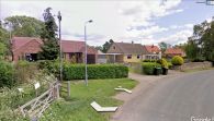
These homes on Gillamoor Road sit in the former Plumpton Park / Google Earth Street View.
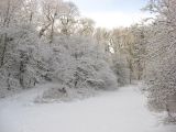
'Snow in Manor Vale'; photo taken immediately north of the former Plumpton Park / T. Eyre, 5 Feb. 2012, Creative Commons, via Geograph.
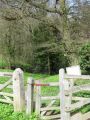
'Path into Spring Wood'; this area was part of or adjacent to Plumpton Park / Pauline E., 10 Apr. 2011, Creative Commons, via Geograph.
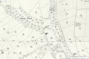
The small gray area near the centre approximately indicates the size, shape and location of Plumpton Park in 1847 / Reproduced with the permission of the National Library of Scotland; Creative Commons. Adapted by Henrik Thiil Nielsen.

