
Maid Marian Way (Nottingham): Difference between revisions
m (Text replacement - "embedformat=h4" to "embedformat=h3") |
m (Text replacement - "ImgGalleryIntro" to "ImageGalleryIntroduction") |
||
| (20 intermediate revisions by 2 users not shown) | |||
| Line 1: | Line 1: | ||
__NOTOC__{{ | __NOTOC__{{PlaceNamesItemTop|Lat=52.951602|Lon=-1.152493|AdministrativeDivision=Nottinghamshire|Vicinity=Runs SSE from intersection with Upper Parliament Street, Tollhouse Hill and Derby Road to Castle Boulevard|Type=Thoroughfare|Interest=Robin Hood name| | ||
Status=Extant|Demonym=English|Riding=|GreaterLondon=|Year=1963|Aka=|Century=20|Cluster1=Maid Marian Way (Nottingham)|Cluster2=Nottingham|Cluster3=|Image=maid-marian-way-nottingham-google-earth-street-view.jpg|Postcards=|ExtraCat1=Places named after Maid Marian|ExtraCat2=|ExtraCat3=|ExtraCat4=|ExtraCat5=|ExtraLink1=|ExtraLink2=|ExtraLink3=|ExtraLink4=|ExtraLink5=|ExtraLinkName1=|ExtraLinkName2=|ExtraLinkName3=|ExtraLinkName4=|ExtraLinkName5=|GeopointPrefix=|GeopointSuffix=|VicinitySuffix=|StatusSuffix=|DatePrefix=|DateSuffix=}} | Status=Extant|Demonym=English|Riding=|GreaterLondon=|Year=1963|Aka=|Century=20|Cluster1=Maid Marian Way (Nottingham)|Cluster2=Nottingham|Cluster3=|Image=maid-marian-way-nottingham-google-earth-street-view.jpg|Postcards=|ExtraCat1=Places named after Maid Marian|ExtraCat2=|ExtraCat3=|ExtraCat4=|ExtraCat5=|ExtraLink1=|ExtraLink2=|ExtraLink3=|ExtraLink4=|ExtraLink5=|ExtraLinkName1=|ExtraLinkName2=|ExtraLinkName3=|ExtraLinkName4=|ExtraLinkName5=|GeopointPrefix=|GeopointSuffix=|VicinitySuffix=|StatusSuffix=|DatePrefix=|DateSuffix=}} | ||
{{#display_map:{{#var:Coords}}~{{#replace:{{PAGENAME}}|'|'}}|width=34%}}<div class="pnMapLegend">Maid Marian Way.</div> | {{#display_map:{{#var:Coords}}~{{#replace:{{PAGENAME}}|'|'}}|width=34%|enablefullscreen=yes}}<div class="pnMapLegend">Maid Marian Way.</div> | ||
[[File:{{#var: | [[File:{{#var:Image}}|thumb|right|500px|Maid Marian Way / Google Earth Street View.]]<div class="no-img"> | ||
<p id="byline">By Henrik Thiil Nielsen, 2018-05-05. Revised by {{#realname:{{REVISIONUSER}}}}, {{REVISIONYEAR}}-{{REVISIONMONTH}}-{{REVISIONDAY2}}.</p | <p id="byline">By Henrik Thiil Nielsen, 2018-05-05. Revised by {{#realname:{{REVISIONUSER}}}}, {{REVISIONYEAR}}-{{REVISIONMONTH}}-{{REVISIONDAY2}}.</p> | ||
Planned in the years after WWII and constructed during the early 1960s, Maid Marian Way is a two-lane highway running through a central area of Nottingham. | Planned in the years after WWII and constructed during the early 1960s, Maid Marian Way is a two-lane highway running through a central area of Nottingham. | ||
In late 1945, Nottingham city council decided that a new road was needed to handle the steadily increasing volume of traffic passing through the centre of the city. The construction of Maid Marian Way was decided against the wish of many citizens by a council that ignored the opinion of at least one expert as well as criticism from the county history society, The Thoroton Society of Nottinghamshire, which declared the project an “antiquarian calamity”. A public vote in 1946 with a turnout of little more than 7 per cent failed to stop the project. After years of heated debate and strenuous protests, construction began in 1963. Several Medieval streets and many old houses had to give way for Maid Marian Way, which within a couple of years had come to be referred to, at least locally, as one of the ugliest street in Europe.<ref>[https://www.nottinghampost.com/news/history/look-back-history-maid-marian-1198903 Smart, Andy. 'A Look Back at the History of Maid Marian Way - "Europe's Ugliest Street"', ''Nottingham Post'' (2018-02-11).]</ref> Today, when the trees have grown tall and we have become more accustomed to concrete, one may perhaps feel that Maid Marian Way is no worse than so many other city streets of the post-WWI era, but as is often the case with such developments, the real tragedy lies in what was lost. Part of this can be seen in a recommended publication in Nottinghamshire Archives' ''Turning back the Pages'' series (see Discussion below). | In late 1945, Nottingham city council decided that a new road was needed to handle the steadily increasing volume of traffic passing through the centre of the city. The construction of Maid Marian Way was decided against the wish of many citizens by a council that ignored the opinion of at least one expert as well as criticism from the county history society, The Thoroton Society of Nottinghamshire, which declared the project an “antiquarian calamity”. A public vote in 1946 with a turnout of little more than 7 per cent failed to stop the project. After years of heated debate and strenuous protests, construction began in 1963. Several Medieval streets and many old houses had to give way for Maid Marian Way, which within a couple of years had come to be referred to, at least locally, as one of the ugliest street in Europe.<ref>[https://www.nottinghampost.com/news/history/look-back-history-maid-marian-1198903 Smart, Andy. 'A Look Back at the History of Maid Marian Way - "Europe's Ugliest Street"', ''Nottingham Post'' (2018-02-11).]</ref> Today, when the trees have grown tall and we have become more accustomed to concrete, one may perhaps feel that Maid Marian Way is no worse than so many other city streets of the post-WWI era, but as is often the case with such developments, the real tragedy lies in what was lost. Part of this can be seen in a recommended publication in Nottinghamshire Archives' ''Turning back the Pages'' series (see Discussion below). | ||
I am aware of just two major city planning and architecture mistakes with Robin Hood-related names: Nottingham's brutal Maid Marian Way and the brutalist [[Robin Hood Gardens (Poplar)| Robin Hood Gardens in Poplar]]. The latter is now finally being demolished.{{ | I am aware of just two major city planning and architecture mistakes with Robin Hood-related names: Nottingham's brutal Maid Marian Way and the brutalist [[Robin Hood Gardens (Poplar)| Robin Hood Gardens in Poplar]]. The latter is now finally being demolished.{{PlaceNamesItemAllusionsAndRecords}} | ||
== Gazetteers == | == Gazetteers == | ||
* Not included in {{:Dobson, Richard Barrie 1976a}}, pp. 293-311. | * Not included in {{:Dobson, Richard Barrie 1976a}}, pp. 293-311. | ||
| Line 22: | Line 22: | ||
* [http://maps.nls.uk/geo/explore/#zoom=16&lat=52.9521&lon=-1.1600&layers=6&b=1 6" O.S. map ''Nottinghamshire'' XLII.NW (1901; rev. 1899)] (georeferenced) | * [http://maps.nls.uk/geo/explore/#zoom=16&lat=52.9521&lon=-1.1600&layers=6&b=1 6" O.S. map ''Nottinghamshire'' XLII.NW (1901; rev. 1899)] (georeferenced) | ||
* [https://maps.nls.uk/view/101603262#zoom=4&lat=3933&lon=5147&layers=BT 6" O.S. map ''Nottinghamshire'' XLII.NW (1920; rev. 1919)] | * [https://maps.nls.uk/view/101603262#zoom=4&lat=3933&lon=5147&layers=BT 6" O.S. map ''Nottinghamshire'' XLII.NW (1920; rev. 1919)] | ||
* [https://maps.nls.uk/view/101603259#zoom=4&lat=3854&lon=5162&layers=BT 6" O.S. map ''Nottinghamshire'' XLII.NW (''c.'' 1947; rev. 1938)] | * [https://maps.nls.uk/view/101603259#zoom=4&lat=3854&lon=5162&layers=BT 6" O.S. map ''Nottinghamshire'' XLII.NW (''c.'' 1947; rev. 1938).] | ||
== Discussion == | == Discussion == | ||
| Line 29: | Line 29: | ||
== Background == | == Background == | ||
* {{:Nottingham Wayfarers' Rambling Club 1994a}}, p. 1 | |||
* [http://www.thorotonsociety.org.uk/ The Thoroton Society] | * [http://www.thorotonsociety.org.uk/ The Thoroton Society] | ||
* [https://en.wikipedia.org/wiki/Nottingham Wikipedia: Nottingham] | * [https://en.wikipedia.org/wiki/Nottingham Wikipedia: Nottingham] | ||
| Line 34: | Line 35: | ||
<!--== Brief mention == | <!--== Brief mention == | ||
* --> | * --> | ||
{{ | {{PlaceNamesItemAlsoSee}} | ||
== Notes == | == Notes == | ||
<references/> | <references/> | ||
</div> | |||
<div id="gallery"> | |||
< | {{ImageGalleryIntroduction}} | ||
{{ | |||
<gallery widths="195px"> | <gallery widths="195px"> | ||
File:maid-marian-way-nottingham-google-earth-street-view.jpg|Google Earth Street View. | File:maid-marian-way-nottingham-google-earth-street-view.jpg|Google Earth Street View. | ||
| Line 53: | Line 54: | ||
File:geograph-4213350-by-Derek-Harper.jpg|Maid Marian Way / [http://www.geograph.org.uk/photo/4213350 Derek Harper, 12 Oct. 2014, Creative Commons.] | File:geograph-4213350-by-Derek-Harper.jpg|Maid Marian Way / [http://www.geograph.org.uk/photo/4213350 Derek Harper, 12 Oct. 2014, Creative Commons.] | ||
</gallery> | </gallery> | ||
</div> | |||
{{PlaceNamesItemNavigation}} | |||
{{ | |||
Latest revision as of 13:50, 7 January 2021
| Locality | |
|---|---|
| Coordinate | 52.951602, -1.152493 |
| Adm. div. | Nottinghamshire |
| Vicinity | Runs SSE from intersection with Upper Parliament Street, Tollhouse Hill and Derby Road to Castle Boulevard |
| Type | Thoroughfare |
| Interest | Robin Hood name |
| Status | Extant |
| First Record | 1963 |

By Henrik Thiil Nielsen, 2018-05-05. Revised by Henrik Thiil Nielsen, 2021-01-07.
Planned in the years after WWII and constructed during the early 1960s, Maid Marian Way is a two-lane highway running through a central area of Nottingham.
In late 1945, Nottingham city council decided that a new road was needed to handle the steadily increasing volume of traffic passing through the centre of the city. The construction of Maid Marian Way was decided against the wish of many citizens by a council that ignored the opinion of at least one expert as well as criticism from the county history society, The Thoroton Society of Nottinghamshire, which declared the project an “antiquarian calamity”. A public vote in 1946 with a turnout of little more than 7 per cent failed to stop the project. After years of heated debate and strenuous protests, construction began in 1963. Several Medieval streets and many old houses had to give way for Maid Marian Way, which within a couple of years had come to be referred to, at least locally, as one of the ugliest street in Europe.[1] Today, when the trees have grown tall and we have become more accustomed to concrete, one may perhaps feel that Maid Marian Way is no worse than so many other city streets of the post-WWI era, but as is often the case with such developments, the real tragedy lies in what was lost. Part of this can be seen in a recommended publication in Nottinghamshire Archives' Turning back the Pages series (see Discussion below).
I am aware of just two major city planning and architecture mistakes with Robin Hood-related names: Nottingham's brutal Maid Marian Way and the brutalist Robin Hood Gardens in Poplar. The latter is now finally being demolished.
Gazetteers
- Not included in Dobson, R. B., ed.; Taylor, J., ed. Rymes of Robyn Hood: an Introduction to the English Outlaw (London, 1976), pp. 293-311.
Maps
- 25" O.S. map Nottinghamshire XLII.2 (1881; surveyed 1881)
- 25" O.S. map Nottinghamshire XLII.2 (1901; rev. 1899)
- 25" O.S. map Nottinghamshire XLII.2 (1901; rev. 1899) (georeferenced)
- 25" O.S. map Nottinghamshire XLII.2 (1915; rev. 1913)
- 6" O.S. map Nottinghamshire XLII.NW (1885; surveyed 1880-81)
- 6" O.S. map Nottinghamshire XLII.NW (1901; rev. 1899)
- 6" O.S. map Nottinghamshire XLII.NW (1901; rev. 1899) (georeferenced)
- 6" O.S. map Nottinghamshire XLII.NW (1920; rev. 1919)
- 6" O.S. map Nottinghamshire XLII.NW (c. 1947; rev. 1938).
Discussion
- Smart, Andy. 'A Look Back at the History of Maid Marian Way - "Europe's Ugliest Street"', Nottingham Post (2018-02-11)
- [Weir, Chris, compil.]; [Smith, Nick, compil.]; [Dorrington, Mark, introd.] Nottinghamshire Archives, compil. Turning back the Pages in.... Maid Marian Way ([Nottingham], ©2011).
Background
- Nottingham Wayfarers' Rambling Club; Price, Roland, introd. The Robin Hood Walks: A Comprehensive Guide to Walks in Robin Hood Country including the Third Edition of the Guide to the Full Route of Nottinghamshire's First Recreational Footpath, The Robin Hood Way (Leicester: Cordee, ©1994), p. 1
- The Thoroton Society
- Wikipedia: Nottingham
- Wikipedia: Thoroton Society of Nottinghamshire.
Also see
- Maid Marian Way (Nottingham) place-name cluster
- Nottingham place-name cluster
- Places named after Maid Marian.
Notes
Image gallery
Click any image to display it in the lightbox, where you can navigate between images by clicking in the right or left side of the current image.
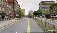
Google Earth Street View.

Maid Marian Way / David Hallam-Jones, 23 Jun. 2012, Creative Commons.

Maid Marian Way / Andrew Abbott, 20 Jun. 2010, Creative Commons.

New City House, Maid Marian Way / Stephen Richards, 18 Jun. 2012, Creative Commons.

Maid Marian Way / Andrew Abbott, 10 Jun. 2010, Creative Commons.

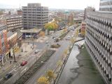
Maid Marian Way with 'several wholly undistinguished tower blocks' / John Sutton, 22 Apr. 2015, Creative Commons.
Maid Marian Way / Andy Jamieson, 18 Nov. 2008, Creative Commons.

Newtown House, Maid Marian Way / Stephen Richards, 19 Jun. 2012, Creative Commons.

Maid Marian Way / Derek Harper, 12 Oct. 2014, Creative Commons.


