Low Robin Hood (Denholme): Difference between revisions
mNo edit summary |
mNo edit summary |
||
| Line 8: | Line 8: | ||
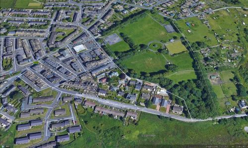
Part of the grounds of Foster Park in Denholme was a piece of farmland known as 'Low Robin Hood' in 1849. | Part of the grounds of Foster Park in Denholme was a piece of farmland known as 'Low Robin Hood' in 1849. | ||
'Low Robin Hood' is listed in the 1849 tithe award for Thornton in the parish of Bradford with the representatives of Mr Buck as landowners, Joseph Maud as occupier, state of cultivation as 'Arable', and an area of 2 acres, 2 rood and 19 perches ({{AcreRoodPerchToM2|2|2|19}} m<sup>2</sup>).<ref>[https://www.thegenealogist.com Tithe award for the township of Thornton in the parish of Bradford (1849)] (Piece 043, Sub-Piece 399, Image 307, #1457); [https://www.thegenealogist.com Tithe award map for the township of Thornton in the parish of Bradford (1849)] (Piece 43, Sub-Piece 399, Sub-Image 001, #1457 – Genealogist.com; subscription required).</ref> The plot immediately north of 'Low Robin Hood' was called [[Robin Hood (Denholme)|Robin Hood]], that at the top was [[Little John (Denholme)|Little John]]. Together these three contiguous plots covered and area nearly identical with the present park. | 'Low Robin Hood' is listed in the 1849 tithe award for Thornton in the parish of Bradford with the representatives of Mr Buck as landowners, Joseph Maud as occupier, state of cultivation as 'Arable', and an area of 2 acres, 2 rood and 19 perches ({{AcreRoodPerchToM2|2|2|19}} m<sup>2</sup>).<ref>[https://www.thegenealogist.com Tithe award for the township of Thornton in the parish of Bradford (1849)] (Piece 043, Sub-Piece 399, Image 307, #1457); [https://www.thegenealogist.com Tithe award map for the township of Thornton in the parish of Bradford (1849)] (Piece 43, Sub-Piece 399, Sub-Image 001, #1457 – Genealogist.com; subscription required).</ref> The plot immediately north of 'Low Robin Hood' was called [[Robin Hood (Denholme)|Robin Hood]], that at the top was [[Little John (Denholme)|Little John]]. Together these three contiguous plots covered and area nearly identical with the present park. 'Low Robin Hood' owed its name, no doubt, to its being at a slightly lower altitude than 'Robin Hood' ''tout court'' to the north. For a discussion of the name of the latter, see [[Robin Hood (Denholme)|Robin Hood]]. | ||
{{PnItemQry}} | {{PnItemQry}} | ||
== Gazetteers == | == Gazetteers == | ||
Revision as of 23:21, 18 July 2020
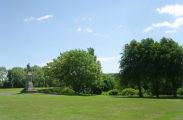
[[File:|thumb|right|500px|Looking towards the part of Foster Park that was known as 'Low Robin Hood' in 1849 / Betty Longbottom, 10 June 2008; Creative Commons, via Geograph.]]
By Henrik Thiil Nielsen, 2020-07-18. Revised by Henrik Thiil Nielsen, 2020-07-18.
Part of the grounds of Foster Park in Denholme was a piece of farmland known as 'Low Robin Hood' in 1849.
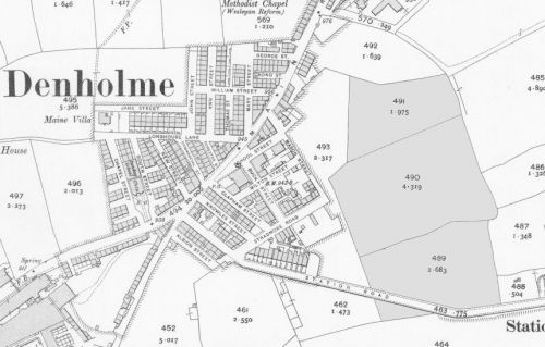
'Low Robin Hood' is listed in the 1849 tithe award for Thornton in the parish of Bradford with the representatives of Mr Buck as landowners, Joseph Maud as occupier, state of cultivation as 'Arable', and an area of 2 acres, 2 rood and 19 perches (Template:AcreRoodPerchToM2 m2).[1] The plot immediately north of 'Low Robin Hood' was called Robin Hood, that at the top was Little John. Together these three contiguous plots covered and area nearly identical with the present park. 'Low Robin Hood' owed its name, no doubt, to its being at a slightly lower altitude than 'Robin Hood' tout court to the north. For a discussion of the name of the latter, see Robin Hood. Template:PnItemQry
Gazetteers
- Not included in Dobson, R. B., ed.; Taylor, J., ed. Rymes of Robyn Hood: an Introduction to the English Outlaw (London, 1976), pp. 293-311.
MS sources
- Tithe award for the township of Thornton in the parish of Bradford (1849) (Piece 043, Sub-Piece 399, Image 307, #1457 – Genealogist.com; subscription required)
- Tithe award map for the township of Thornton in the parish of Bradford (1849) (Piece 43, Sub-Piece 399, Sub-Image 001, #1457 – Genealogist.com; subscription required).
Maps
- 25" O.S. map Yorkshire CCXV.4 (1894; surveyed 1892)
- 25" O.S. map Yorkshire CCXV.4 (1908; rev. 1905) (georeferenced)
- 25" O.S. map Yorkshire CCXV.4 (1908; rev. 1905)
- 25" O.S. map Yorkshire CCXV.4 (1920; rev. 1914)
- 25" O.S. map Yorkshire CCXV.4 (1935; rev. 1934)
- 6" O.S. map Yorkshire 215 (1852; surveyed 1847–49)
- 6" O.S. map Yorkshire CCXV.NE (1894; surveyed 1892–93)
- 6" O.S. map Yorkshire CCXV.NE (1908; rev. 1905) (georeferenced)
- 6" O.S. map Yorkshire CCXV.NE (1908; rev. 1905)
- 6" O.S. map Yorkshire CCXV.NE (1934; rev. 1934)
- 6" O.S. map Yorkshire CCXV.NE (1946; rev. 1938).
Notes
- ↑ Tithe award for the township of Thornton in the parish of Bradford (1849) (Piece 043, Sub-Piece 399, Image 307, #1457); Tithe award map for the township of Thornton in the parish of Bradford (1849) (Piece 43, Sub-Piece 399, Sub-Image 001, #1457 – Genealogist.com; subscription required).
Looking towards the part of Foster Park that was known as 'Low Robin Hood' in 1849 / Betty Longbottom, 10 June 2008; Creative Commons, via Geograph.
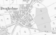
The bottom-most of the three plots in gray was 'Low Robin Hood' / Reproduced with the permission of the National Library of Scotland; Creative Commons.

