
Little Robin Hood Hay (Agden): Difference between revisions
mNo edit summary |
m (Text replacement - ", image" to ", Image") |
||
| Line 5: | Line 5: | ||
Superimposed on a modern map, Little Robin Hood Hay in Agden, in the parish of Rostherne, Cheshire, would be seen to straddle the M56 about 100 to 200 metres (or more) West of the Reddy Lane underpass. The field name occurs in the 1848 tithe award for Agden. | Superimposed on a modern map, Little Robin Hood Hay in Agden, in the parish of Rostherne, Cheshire, would be seen to straddle the M56 about 100 to 200 metres (or more) West of the Reddy Lane underpass. The field name occurs in the 1848 tithe award for Agden. | ||
'Little Robin Hood Hay' is listed there with Sir John Newdigate-Ludford-Chetwode, Baronet, as owner, Thomas Cross as occcupier, 'Arable' as state of cultivation, and an area of 2 acres, 5 roods and 17 perches ({{AcresRoodsPerchesToM2|2|5|17}} m<sup>2</sup>).<ref>1848 tithe award for the township of Agden in the parish of Rostherne, online at the [https://www.thegenealogist.com Genealogist], piece 05, sub-piece 006, | 'Little Robin Hood Hay' is listed there with Sir John Newdigate-Ludford-Chetwode, Baronet, as owner, Thomas Cross as occcupier, 'Arable' as state of cultivation, and an area of 2 acres, 5 roods and 17 perches ({{AcresRoodsPerchesToM2|2|5|17}} m<sup>2</sup>).<ref>1848 tithe award for the township of Agden in the parish of Rostherne, online at the [https://www.thegenealogist.com Genealogist], piece 05, sub-piece 006, Image 004, #60 (£); accompanying map, online at the [https://www.thegenealogist.com Genealogist], piece 05, sub-piece 006, sub-image 001, #60 (£).</ref> It was situated at the northwest end of a larger, irregularly shaped meadow named [[Robin Hood Hay (Agden)|Robin Hood Hay]] ''tout court''. Both plots are roughly indicated on the adapted map detail included in the image gallery below, where we have inadvertently made Little Robin Hood Hay somewhat too large in relation to its larger neighbour. The fairly rectangular shape of the smaller plot and its position relative to Robin Hood Hay suggest that the latter field name applied to the entire meadow before part of it was enclosed and brought under cultivation under the name 'Little Robin Hood Hay'. | ||
The English Place Name Society's survey of Cheshire mentions Robin Hood Hay but not Little Robin Hood Hay.<ref>{{:Dodgson, John McNeal 1970a}}, vol. II, pp. 42, 43.</ref> The lack of modern references on the web suggests that the field name is defunct. | The English Place Name Society's survey of Cheshire mentions Robin Hood Hay but not Little Robin Hood Hay.<ref>{{:Dodgson, John McNeal 1970a}}, vol. II, pp. 42, 43.</ref> The lack of modern references on the web suggests that the field name is defunct. | ||
| Line 15: | Line 15: | ||
== MS sources == | == MS sources == | ||
* 1848 tithe award for the township of Agden in the parish of Rostherne, online at the [https://www.thegenealogist.com Genealogist], piece 05, sub-piece 006, | * 1848 tithe award for the township of Agden in the parish of Rostherne, online at the [https://www.thegenealogist.com Genealogist], piece 05, sub-piece 006, Image 004, #60 (£) | ||
* accompanying map, online at the [https://www.thegenealogist.com Genealogist], piece 05, sub-piece 006, sub-image 001, #60 (£). | * accompanying map, online at the [https://www.thegenealogist.com Genealogist], piece 05, sub-piece 006, sub-image 001, #60 (£). | ||
Revision as of 18:31, 22 April 2022
| Locality | |
|---|---|
| Coordinate | 53.3644, -2.4172 |
| Adm. div. | Cheshire |
| Vicinity | Straddling M56, c. 100 m W of Reddy Lane underpass; Agden in parish of Rostherne |
| Type | Area |
| Interest | Robin Hood name |
| Status | Defunct? |
| First Record | 1848 |

By Henrik Thiil Nielsen, 2021-02-27. Revised by Henrik Thiil Nielsen, 2022-04-22.
Superimposed on a modern map, Little Robin Hood Hay in Agden, in the parish of Rostherne, Cheshire, would be seen to straddle the M56 about 100 to 200 metres (or more) West of the Reddy Lane underpass. The field name occurs in the 1848 tithe award for Agden.
'Little Robin Hood Hay' is listed there with Sir John Newdigate-Ludford-Chetwode, Baronet, as owner, Thomas Cross as occcupier, 'Arable' as state of cultivation, and an area of 2 acres, 5 roods and 17 perches (13582.26 m2).[1] It was situated at the northwest end of a larger, irregularly shaped meadow named Robin Hood Hay tout court. Both plots are roughly indicated on the adapted map detail included in the image gallery below, where we have inadvertently made Little Robin Hood Hay somewhat too large in relation to its larger neighbour. The fairly rectangular shape of the smaller plot and its position relative to Robin Hood Hay suggest that the latter field name applied to the entire meadow before part of it was enclosed and brought under cultivation under the name 'Little Robin Hood Hay'.
The English Place Name Society's survey of Cheshire mentions Robin Hood Hay but not Little Robin Hood Hay.[2] The lack of modern references on the web suggests that the field name is defunct.
Gazetteers
- Not included in Dobson, R. B., ed.; Taylor, J., ed. Rymes of Robyn Hood: an Introduction to the English Outlaw (London, 1976), pp. 293-311.
MS sources
- 1848 tithe award for the township of Agden in the parish of Rostherne, online at the Genealogist, piece 05, sub-piece 006, Image 004, #60 (£)
- accompanying map, online at the Genealogist, piece 05, sub-piece 006, sub-image 001, #60 (£).
Maps
- 25" map Cheshire XVII.12 (c. 1875; surveyed c. 1873). No copy in NLS]
- 25" O.S. map Cheshire XVII.12 (1898; rev. 1897) (georeferenced)
- 25" O.S. map Cheshire XVII.12 (1898; rev. 1897)
- 25" O.S. map Cheshire XVII.12 (1910; rev. 1908)
- 6" O.S. map Cheshire XVII (1882; surveyed 1873–76)
- 6" O.S. map Cheshire XVII.SE (1899; rev. 1897) (georeferenced)
- 6" O.S. map Cheshire XVII.SE (1899; rev. 1897)
- 6" O.S. map Cheshire XVII.SE (1911; rev. 1908)
- 6" O.S. map Cheshire XVII.SE (c. 1933; rev. 1908)
- 6" O.S. map Cheshire XVII.SE (c. 1936; rev. 1908)
- 6" O.S. map Cheshire XVII.SE (c. 1945; rev. 1938).
Background
- Dodgson, John McN.; Rumble, Alexander R. The Place-Names of Cheshire, pts. I-V (English Place-Name Society, vols. XLIV-XLVIII, LIV, LXXIV) (Cambridge, 1970-72; [s.l.], 1981; Nottingham, 1997), vol. II, pp. 42, 43.
Also see
Notes
- ↑ 1848 tithe award for the township of Agden in the parish of Rostherne, online at the Genealogist, piece 05, sub-piece 006, Image 004, #60 (£); accompanying map, online at the Genealogist, piece 05, sub-piece 006, sub-image 001, #60 (£).
- ↑ Dodgson, John McN.; Rumble, Alexander R. The Place-Names of Cheshire, pts. I-V (English Place-Name Society, vols. XLIV-XLVIII, LIV, LXXIV) (Cambridge, 1970-72; [s.l.], 1981; Nottingham, 1997), vol. II, pp. 42, 43.
Image gallery
Click any image to display it in the lightbox, where you can navigate between images by clicking in the right or left side of the current image.

Little Robin Hood Hay would have straddled the M56 / Google Earth Street View.
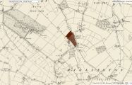
Robin Hood Hay and Little Robin Hood Hay indicated in, respectively, brown and maroon / Detail of 6" O.S. map Cheshire XVII.SE (1899; rev. 1897) (georeferenced); reprod. with perm. of NLS; under Creative Commons Attrib. (CC-BY) license; adapt. Henrik Thiil Nielsen.
