
Little John Street (Manchester)
| Locality | |
|---|---|
| Coordinate | 53.478567, -2.253932 |
| Adm. div. | Lancashire |
| Vicinity | Connecting Great John and Quay streets |
| Type | Thoroughfare |
| Interest | Robin Hood name |
| Status | Extant |
| First Record | 1922 |

By Henrik Thiil Nielsen, 2019-03-05. Revised by Henrik Thiil Nielsen, 2021-01-06.
Little John Street which runs north from Great John Street to Quay Street, Manchester, is such a humble little street its name is only included on 25" O.S. maps, not the 6" maps. It is labelled 'Little John Street' on the 25" map published 1923, based on a revision carried out 1915-16. The 25" maps from c. 1893 and c. 1908 are not online. The street may be included in one or both of these. Since Little John Street is a side street of Great John Street, someone obviously had a sense of humour. A rather similar situation is found with John and Little John streets in Bristol.
Gazetteers
- Not included in Dobson, R. B., ed.; Taylor, J., ed. Rymes of Robyn Hood: an Introduction to the English Outlaw (London, 1976), pp. 293-311.
Maps
- 25" O.S. map Lancashire CIV.10 (c. 1893; surveyed c. 1889-91). No Copy in NLS
- 25" O.S. map Lancashire CIV.10 (c. 1908; rev. c. 1904). No Copy in NLS
- 25" O.S. map Lancashire CIV.10 (1922; rev. 1915-16) (georeferenced)
- 25" O.S. map Lancashire CIV.10 (1922; rev. 1915-16)
- 25" O.S. map Lancashire CIV.10 (1934; rev. 1932)
- 6" O.S. map Lancashire CIV.SW (1909; rev. 1905) (georeferenced)
- 6" O.S. map Lancashire CIV (1848; surveyed 1845)
- 6" O.S. map Lancashire CIV.SW (1896; surveyed 1894)
- 6" O.S. map Lancashire CIV.SW (1909; rev. 1905)
- 6" O.S. map Lancashire CIV (1923; rev. 1915-21)
- 6" O.S. map Lancashire CIV.SW (1923; rev. 1915-16)
- 6" O.S. map Lancashire CIV.SW (1936; rev. 1931-32)
- 6" O.S. map Lancashire CIV.SW (c. 1946; rev. 1938).
Also see

Little John Street, leading S–N from Great John Street to Quay Street / Gerald England, 14 Jul. 2018, Creative Commons, via Geograph.
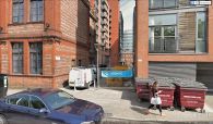
On Great John Street, looking north into Little John Street.
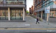
On Quay Street, looking south into Little John Street.

