
Little John Street (Manchester): Difference between revisions
mNo edit summary |
m (Text replacement - "No Copy in NLS" to "No copy in NLS") |
||
| (24 intermediate revisions by 2 users not shown) | |||
| Line 1: | Line 1: | ||
__NOTOC__{{ | __NOTOC__{{PlaceNamesItemTop|Lat=53.478567|Lon=-2.253932|AdministrativeDivision=Lancashire|Vicinity=Connecting Great John and Quay streets|Type=Thoroughfare|Interest=Robin Hood name| | ||
Status=Extant|Demonym=|Riding=|GreaterLondon=|Year= | Status=Extant|Demonym=|Riding=|GreaterLondon=|Year=1918|Aka=|Century=|Cluster1=Manchester|Cluster2=|Cluster3=|Image=geograph-5964288-by-Gerald-England.jpg|Postcards=|ExtraCat1=|ExtraCat2=|ExtraCat3=|ExtraCat4=|ExtraCat5=|ExtraLink1=Little John Street (Bristol)|ExtraLink2=|ExtraLink3=|ExtraLink4=|ExtraLink5=|ExtraLinkName1=|ExtraLinkName2=|ExtraLinkName3=|ExtraLinkName4=|ExtraLinkName5=|GeopointPrefix=|GeopointSuffix=|VicinitySuffix=|StatusSuffix=|DatePrefix=|DateSuffix=}} | ||
{{#display_map:{{#var:Coords}}~{{#replace:{{PAGENAME}}|'|'}}|width=34%}}<div class="pnMapLegend">Little John Street.</div> | {{#display_map:{{#var:Coords}}~{{#replace:{{PAGENAME}}|'|'}}|width=34%|enablefullscreen=yes}}<div class="pnMapLegend">Little John Street.</div> | ||
[[File:{{#var: | [[File:{{#var:Image}}|thumb|right|380px|Little John Street, running S–N from Great John Street to Quay Street / [https://www.geograph.org.uk/photo/5964288 Gerald England, 14 Jul. 2018, Creative Commons, via Geograph.]]]<div class="no-img"> | ||
<p id="byline">By Henrik Thiil Nielsen, 2019-03-05. Revised by {{#realname:{{REVISIONUSER}}}}, {{REVISIONYEAR}}-{{REVISIONMONTH}}-{{REVISIONDAY2}}.</p | <p id="byline">By Henrik Thiil Nielsen, 2019-03-05. Revised by {{#realname:{{REVISIONUSER}}}}, {{REVISIONYEAR}}-{{REVISIONMONTH}}-{{REVISIONDAY2}}.</p> | ||
Little John Street which runs north from Great John Street to Quay Street, Manchester, is such a humble little street its name is only included on 25" O.S. maps, not the 6" maps. It is labelled | Little John Street which runs north from Great John Street to Quay Street, Manchester, is such a humble little street its name is only included on 25" O.S. maps, not the 6" maps. It is labelled 'Little John Street' on the 25" map published 1923, based on a revision carried out 1915–16. The 25" maps from c. 1893 and c. 1908 are not online. The street may be included in one or both of these. The street was in existence by 1918, when a family moved from 42 Lower Byrom Street to 15 Little John Street.<ref>[https://discovery.nationalarchives.gov.uk/details/r/9aeed031-c9d8-49f2-98b5-ad389674a51e National Archives: Photographs related to Elsie Holmes and Family.]</ref> | ||
{{ | |||
Since Little John Street is a side street of Great John Street, someone obviously had a sense of humour. A rather similar situation is found with [[Little John Street (Bristol)|John and Little John streets in Bristol.]] | |||
{{PlaceNamesItemAllusionsAndRecords}} | |||
== Gazetteers == | == Gazetteers == | ||
* Not included in {{:Dobson, Richard Barrie 1976a}}, pp. 293-311. | * Not included in {{:Dobson, Richard Barrie 1976a}}, pp. 293-311. | ||
== Sources == | |||
* -- | * [https://discovery.nationalarchives.gov.uk/details/r/9aeed031-c9d8-49f2-98b5-ad389674a51e National Archives: Photographs related to Elsie Holmes and Family.] | ||
== Maps == | == Maps == | ||
* 25" O.S. map ''Lancashire'' CIV.10 (''c.'' 1893; surveyed ''c.'' 1889-91). No copy in NLS | |||
* 25" O.S. map ''Lancashire'' CIV.10 (''c.'' 1908; rev. ''c.'' 1904). No copy in NLS | |||
* [https://maps.nls.uk/geo/explore/#zoom=18&lat=53.4788&lon=-2.2547&layers=168&b=5 25" O.S. map ''Lancashire'' CIV.10 (1922; rev. 1915-16)] (georeferenced) | |||
* [https://maps.nls.uk/view/126522836#zoom=5&lat=9252&lon=8375&layers=BT 25" O.S. map ''Lancashire'' CIV.10 (1922; rev. 1915-16)] | |||
* [https://maps.nls.uk/view/126522839#zoom=5&lat=9306&lon=8240&layers=BT 25" O.S. map ''Lancashire'' CIV.10 (1934; rev. 1932)] | |||
* [https://maps.nls.uk/geo/explore/#zoom=16&lat=53.4787&lon=-2.2566&layers=6&b=5 6" O.S. map ''Lancashire'' CIV.SW (1909; rev. 1905)] (georeferenced) | * [https://maps.nls.uk/geo/explore/#zoom=16&lat=53.4787&lon=-2.2566&layers=6&b=5 6" O.S. map ''Lancashire'' CIV.SW (1909; rev. 1905)] (georeferenced) | ||
* [https://maps.nls.uk/view/102344087#zoom=6&lat=4695&lon=5745&layers=BT 6" O.S. map ''Lancashire'' CIV (1848; surveyed 1845)] | * [https://maps.nls.uk/view/102344087#zoom=6&lat=4695&lon=5745&layers=BT 6" O.S. map ''Lancashire'' CIV (1848; surveyed 1845)] | ||
| Line 18: | Line 25: | ||
* [https://maps.nls.uk/view/101103806#zoom=5&lat=5652&lon=6265&layers=BT 6" O.S. map ''Lancashire'' CIV.SW (1923; rev. 1915-16)] | * [https://maps.nls.uk/view/101103806#zoom=5&lat=5652&lon=6265&layers=BT 6" O.S. map ''Lancashire'' CIV.SW (1923; rev. 1915-16)] | ||
* [https://maps.nls.uk/view/101103803#zoom=5&lat=5745&lon=6317&layers=BT 6" O.S. map ''Lancashire'' CIV.SW (1936; rev. 1931-32)] | * [https://maps.nls.uk/view/101103803#zoom=5&lat=5745&lon=6317&layers=BT 6" O.S. map ''Lancashire'' CIV.SW (1936; rev. 1931-32)] | ||
* [https://maps.nls.uk/view/102339522#zoom=5&lat=5623&lon=6328&layers=BT 6" O.S. map ''Lancashire'' CIV.SW (''c.'' 1946; rev. 1938 | * [https://maps.nls.uk/view/102339522#zoom=5&lat=5623&lon=6328&layers=BT 6" O.S. map ''Lancashire'' CIV.SW (''c.'' 1946; rev. 1938).] | ||
<!--== Discussion == | <!--== Discussion == | ||
* --> | * --> | ||
| Line 30: | Line 32: | ||
<!--== Brief mention == | <!--== Brief mention == | ||
* --> | * --> | ||
{{ | {{PlaceNamesItemAlsoSee}}<!-- | ||
== Notes == | == Notes == | ||
<references/>--> | <references/>--> | ||
</div> | |||
<div id="gallery"> | |||
< | {{ImageGalleryIntroduction}} | ||
{{ | |||
<gallery widths="195px"> | <gallery widths="195px"> | ||
File:geograph-5964288-by-Gerald-England.jpg|Little John Street, leading S–N from Great John Street to Quay Street / [https://www.geograph.org.uk/photo/5964288 Gerald England, 14 Jul. 2018, Creative Commons via Geograph.] | File:geograph-5964288-by-Gerald-England.jpg|Little John Street, leading S–N from Great John Street to Quay Street / [https://www.geograph.org.uk/photo/5964288 Gerald England, 14 Jul. 2018, Creative Commons, via Geograph.] | ||
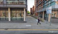
File:little-john-street-manchester-google-earth-street-view-1.jpg|On Great John Street, looking north into Little John Street. | File:little-john-street-manchester-google-earth-street-view-1.jpg|On Great John Street, looking north into Little John Street. | ||
File:little-john-street-manchester-google-earth-street-view-2.jpg|On Quay Street, looking south into Little John Street. | File:little-john-street-manchester-google-earth-street-view-2.jpg|On Quay Street, looking south into Little John Street. | ||
</gallery> | </gallery> | ||
</div> | |||
{{PlaceNamesItemNavigation}} | |||
{{ | |||
Latest revision as of 01:02, 13 February 2021
| Locality | |
|---|---|
| Coordinate | 53.478567, -2.253932 |
| Adm. div. | Lancashire |
| Vicinity | Connecting Great John and Quay streets |
| Type | Thoroughfare |
| Interest | Robin Hood name |
| Status | Extant |
| First Record | 1918 |

By Henrik Thiil Nielsen, 2019-03-05. Revised by Henrik Thiil Nielsen, 2021-02-13.
Little John Street which runs north from Great John Street to Quay Street, Manchester, is such a humble little street its name is only included on 25" O.S. maps, not the 6" maps. It is labelled 'Little John Street' on the 25" map published 1923, based on a revision carried out 1915–16. The 25" maps from c. 1893 and c. 1908 are not online. The street may be included in one or both of these. The street was in existence by 1918, when a family moved from 42 Lower Byrom Street to 15 Little John Street.[1]
Since Little John Street is a side street of Great John Street, someone obviously had a sense of humour. A rather similar situation is found with John and Little John streets in Bristol.
Gazetteers
- Not included in Dobson, R. B., ed.; Taylor, J., ed. Rymes of Robyn Hood: an Introduction to the English Outlaw (London, 1976), pp. 293-311.
Sources
Maps
- 25" O.S. map Lancashire CIV.10 (c. 1893; surveyed c. 1889-91). No copy in NLS
- 25" O.S. map Lancashire CIV.10 (c. 1908; rev. c. 1904). No copy in NLS
- 25" O.S. map Lancashire CIV.10 (1922; rev. 1915-16) (georeferenced)
- 25" O.S. map Lancashire CIV.10 (1922; rev. 1915-16)
- 25" O.S. map Lancashire CIV.10 (1934; rev. 1932)
- 6" O.S. map Lancashire CIV.SW (1909; rev. 1905) (georeferenced)
- 6" O.S. map Lancashire CIV (1848; surveyed 1845)
- 6" O.S. map Lancashire CIV.SW (1896; surveyed 1894)
- 6" O.S. map Lancashire CIV.SW (1909; rev. 1905)
- 6" O.S. map Lancashire CIV (1923; rev. 1915-21)
- 6" O.S. map Lancashire CIV.SW (1923; rev. 1915-16)
- 6" O.S. map Lancashire CIV.SW (1936; rev. 1931-32)
- 6" O.S. map Lancashire CIV.SW (c. 1946; rev. 1938).
Also see
Image gallery
Click any image to display it in the lightbox, where you can navigate between images by clicking in the right or left side of the current image.

Little John Street, leading S–N from Great John Street to Quay Street / Gerald England, 14 Jul. 2018, Creative Commons, via Geograph.

On Great John Street, looking north into Little John Street.
On Quay Street, looking south into Little John Street.

