Little John Street (Bristol): Difference between revisions
From International Robin Hood Bibliography
m (Text replacement - "AdmDiv" to "AdministrativeDivision") |
m (Text replacement - "PnItemTop" to "PlaceNamesItemTop") |
||
| Line 1: | Line 1: | ||
__NOTOC__{{ | __NOTOC__{{PlaceNamesItemTop|Lat=51.456150|Lon=-2.594029|AdministrativeDivision=Gloucestershire|Vicinity=Side street of John Street; S of Nelson Street|Type=Thoroughfare|Interest=Robin Hood name| | ||
Status=Extant|Demonym=|Riding=|GreaterLondon=|Year=1832|Aka=|Century=|Cluster1=|Cluster2=|Cluster3=|Image=little-john-street-bristol-google-earth-street-view.jpg|Postcards=|ExtraCat1=Places named after Little John|ExtraCat2=|ExtraCat3=|ExtraCat4=|ExtraCat5=|ExtraLink1=Little John Street (Manchester)|ExtraLink2=|ExtraLink3=|ExtraLink4=|ExtraLink5=|ExtraLinkName1=|ExtraLinkName2=|ExtraLinkName3=|ExtraLinkName4=|ExtraLinkName5=|GeopointPrefix=|GeopointSuffix=|VicinitySuffix=|StatusSuffix=|DatePrefix=|DateSuffix=}} | Status=Extant|Demonym=|Riding=|GreaterLondon=|Year=1832|Aka=|Century=|Cluster1=|Cluster2=|Cluster3=|Image=little-john-street-bristol-google-earth-street-view.jpg|Postcards=|ExtraCat1=Places named after Little John|ExtraCat2=|ExtraCat3=|ExtraCat4=|ExtraCat5=|ExtraLink1=Little John Street (Manchester)|ExtraLink2=|ExtraLink3=|ExtraLink4=|ExtraLink5=|ExtraLinkName1=|ExtraLinkName2=|ExtraLinkName3=|ExtraLinkName4=|ExtraLinkName5=|GeopointPrefix=|GeopointSuffix=|VicinitySuffix=|StatusSuffix=|DatePrefix=|DateSuffix=}} | ||
{{#display_map:{{#var:Coords}}~{{#replace:{{PAGENAME}}|'|'}}|width=34%|fullscreen=yes}}<div class="pnMapLegend">Little John Street.</div> | {{#display_map:{{#var:Coords}}~{{#replace:{{PAGENAME}}|'|'}}|width=34%|fullscreen=yes}}<div class="pnMapLegend">Little John Street.</div> | ||
Revision as of 23:53, 5 January 2021
| Locality | |
|---|---|
| Coordinate | 51.45615, -2.594029 |
| Adm. div. | Gloucestershire |
| Vicinity | Side street of John Street; S of Nelson Street |
| Type | Thoroughfare |
| Interest | Robin Hood name |
| Status | Extant |
| First Record | 1832 |
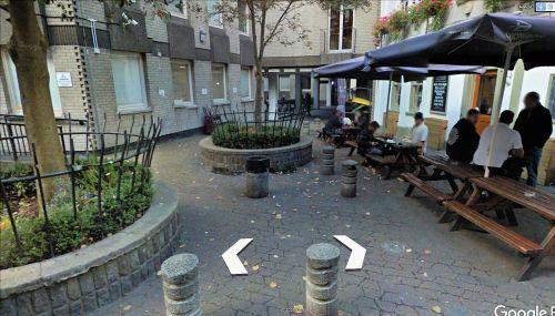
Little John Street.
By Henrik Thiil Nielsen, 2020-05-26. Revised by Henrik Thiil Nielsen, 2021-01-05.
The pedestrianised cul de sac Little John Street in Bristol is a side street of John Street.
The earliest record of this street known to IRHB is the Bristol Poll Book (1833), which lists voters at the parliamentary election in 1832.[1] The earliest cartographical evidence found so far is a 25" O.S. map of the area published in 1885 (see Maps section below). A rather similar situation is found with Great and Little John streets in Manchester. Template:PnItemQry
Gazetteers
- Not included in Dobson, R. B., ed.; Taylor, J., ed. Rymes of Robyn Hood: an Introduction to the English Outlaw (London, 1976), pp. 293-311.
Sources
Maps
- 25" O.S. map Gloucestershire LXXI.16 (1885; surveyed 1880–82)
- 25" O.S. map Gloucestershire LXXI.16 (1903; rev. 1901) (georeferenced)
- 25" O.S. map Gloucestershire LXXI.16 (1903; rev. 1901)
- 25" O.S. map Gloucestershire LXXI.16 (1918; rev. 1913)
- 6" O.S. map Gloucestershire LXXI.SE (1888; surveyed 1880–83)
- 6" O.S. map Gloucestershire LXXI.SE (1904; rev. 1901–02)
- 6" O.S. map Somerset VI.NE (1905; rev. 1901–02) (georeferenced)
- 6" O.S. map Somerset VI.NE (1905; rev. 1901–02)
- 6" O.S. map Gloucestershire LXXI (1921; rev. 1912–13)
- 6" O.S. map Gloucestershire LXXI.SE (1921; rev. 1912–13)
- 6" O.S. map Somerset VI (1921; rev. 1912–13)
- 6" O.S. map Somerset VI.NE (1921; rev. 1912–13)
- 6" O.S. map Somerset VI.NE (1933; rev. 1930)
- 6" O.S. map Gloucestershire LXXI.SE (c. 1944; rev. 1938)
- 6" O.S. map Somerset VI.NE (c. 1945; rev. 1938)
- 6" O.S. map Gloucestershire LXXI.SE (c. 1946; rev. 1938)
- 6" O.S. map Somerset VI.NE (c. 1947; rev. 1938).
Notes
- ↑ Anonymous, compil. The Bristol Poll Book, being a List of the Householders, Freeholders, and Freemen, who voted at the General Election, for Members to serve in Parliament, for the City and Council of Bristol, which commenced on Wednesday, December the 12th, and terminated on Thursday, december the 13th, 1832 (Bristol, 1833), p. 58.

