
Little John Inn (Ravenshead): Difference between revisions
From International Robin Hood Bibliography
m (Text replacement - "PlaceNamesItemQuery" to "PlaceNamesItemAllusionsAndRecords") |
m (Text replacement - "ImgGalleryIntro" to "ImageGalleryIntroduction") |
||
| Line 37: | Line 37: | ||
<div id="gallery"> | <div id="gallery"> | ||
{{ | {{ImageGalleryIntroduction}} | ||
<gallery widths="195px"> | <gallery widths="195px"> | ||
little-john-inn-ravenshead-google-earth-street-view-1.jpg|Little John Inn / Google Earth Street View | little-john-inn-ravenshead-google-earth-street-view-1.jpg|Little John Inn / Google Earth Street View | ||
Latest revision as of 13:50, 7 January 2021
| Locality | |
|---|---|
| Coordinate | 53.092724, -1.15617 |
| Adm. div. | Nottinghamshire |
| Vicinity | On N side of Main Road in Ravenshead |
| Type | Public house |
| Interest | Robin Hood name |
| Status | Extant |
| First Record | 1884 |
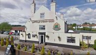
Little John Inn in Ravenshead.

By Henrik Thiil Nielsen, 2018-05-07. Revised by Henrik Thiil Nielsen, 2021-01-07.
Little John Inn is located on the north side of Main Street in Ravenshead, c. 50 m south of a short residential cul-de-sac named 'Robin Hood Terrace'.
The earliest record known at present is a 25" O.S. map from 1884 (see Maps below). Pub Wiki lists publicans for the years 1925–41.[1]
Gazetteers
- Not included in Dobson, R. B., ed.; Taylor, J., ed. Rymes of Robyn Hood: an Introduction to the English Outlaw (London, 1976), pp. 293-311.
Sources
Maps
- 25" O.S. map Nottinghamshire XXVIII.14 (1884; surveyed 1883)
- 25" O.S. map Nottinghamshire XXVIII.14 (1900; rev. 1898)
- 25" O.S. map Nottinghamshire XXVIII.14 (1900; rev. 1898) (georeferenced)
- 25" O.S. map Nottinghamshire XXVIII.14 (1915; rev. 1913)
- 6" O.S. map Nottinghamshire XXVIII.SW (1885; surveyed 1877-83)
- 6" O.S. map Nottinghamshire XXVIII.SW (1900; rev. 1897-98)
- 6" O.S. map Nottinghamshire XXVIII.SW (1900; rev. 1897-98) (georeferenced)
- 6" O.S. map Nottinghamshire XXVIII.SW (1920; rev. 1913)
- 6" O.S. map Nottinghamshire XXVIII.SW (c. 1949; rev. 1939).
Background
- Nottingham Wayfarers' Rambling Club; Price, Roland, introd. The Robin Hood Walks: A Comprehensive Guide to Walks in Robin Hood Country including the Third Edition of the Guide to the Full Route of Nottinghamshire's First Recreational Footpath, The Robin Hood Way (Leicester: Cordee, ©1994), pp. 113, 117
- Wikipedia: Ravenshead.
Also see
Notes
Image gallery
Click any image to display it in the lightbox, where you can navigate between images by clicking in the right or left side of the current image.
Little John Inn / Google Earth Street View
Little John Inn / Google Earth Street View
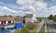
Looking towards the Little John Inn on the B6020, Ravenshead / Tim Heaton, 19 May 2013, Creative Commons, via Geograph.

