
Little John's Ground (Pentridge): Difference between revisions
m (Text replacement - "|service=leaflet}}" to "|service=leaflet|enablefullscreen=yes}}") |
m (Text replacement - "== MS sources == " to "== MS sources === ") |
||
| Line 9: | Line 9: | ||
* Not included in {{:Dobson, Richard Barrie 1976a}}, pp. 293-311. | * Not included in {{:Dobson, Richard Barrie 1976a}}, pp. 293-311. | ||
== MS sources == | == MS sources === | ||
* [https://www.thegenealogist.com/image_viewer/?imagego=yVaqkz_Qlg-fGyJpQu891TJ9ziRQSuSdqWR3Luzp681r0aidcywm22XDzUjx4IIvvc_p8QmkHjIQR6fmcZDnvswC6UnPeZhX8KeQ57hbaR12kgQgfGqR5Mq3n6UtDDaE&r%5B1%5D=10&r%5B2%5D=165&r%5B3%5D=012 1838 tithe award for Pentridge, online at the Genealogist.co.uk, piece 10, sub-piece 165, image 008]; schedule (subscription required) | * [https://www.thegenealogist.com/image_viewer/?imagego=yVaqkz_Qlg-fGyJpQu891TJ9ziRQSuSdqWR3Luzp681r0aidcywm22XDzUjx4IIvvc_p8QmkHjIQR6fmcZDnvswC6UnPeZhX8KeQ57hbaR12kgQgfGqR5Mq3n6UtDDaE&r%5B1%5D=10&r%5B2%5D=165&r%5B3%5D=012 1838 tithe award for Pentridge, online at the Genealogist.co.uk, piece 10, sub-piece 165, image 008]; schedule (subscription required) | ||
* [https://www.thegenealogist.com/image_viewer/?imagego=5QIH2T2WPVLBR_rz7g5lyEcKvVpX0gSQ9AVPicWgEFcoMZGwwRLkpufE22hTN9VqU7htm1DHK4Ehmfg9laJsfV2x_IEu32uNqbtteCNhmqKK-4RyWmdaJeX-Py6GUErO&id=57726698&r%5B1%5D=10&r%5B2%5D=165&r%5B3%5D=001&r%5B4%5D=B%26W+%28TNA%29 1838 tithe map for Pentridge, online at the Genealogist.co.uk, piece 10, sub-piece 165, sub-image 001] (subscription required). | * [https://www.thegenealogist.com/image_viewer/?imagego=5QIH2T2WPVLBR_rz7g5lyEcKvVpX0gSQ9AVPicWgEFcoMZGwwRLkpufE22hTN9VqU7htm1DHK4Ehmfg9laJsfV2x_IEu32uNqbtteCNhmqKK-4RyWmdaJeX-Py6GUErO&id=57726698&r%5B1%5D=10&r%5B2%5D=165&r%5B3%5D=001&r%5B4%5D=B%26W+%28TNA%29 1838 tithe map for Pentridge, online at the Genealogist.co.uk, piece 10, sub-piece 165, sub-image 001] (subscription required). | ||
Revision as of 13:06, 7 May 2020

By Henrik Thiil Nielsen, 2017-10-24. Revised by Henrik Thiil Nielsen, 2020-05-07.
'Little John's Ground' was the name of an area in a close on the east side of Earthpits Lane in Pentridge, immediately southeast of Whitey Top Farm. First recorded in the 1838 tithe award for Pentridge, this field name is noted in the Place-Names of Dorset (1989), but the present entry would seem to be its debut on the world wide web. The 1838 tithe award lists the close as "Little Johns Ground or Whites Hill and Stony Closes", its state of cultivation as arable, its area as 17 acres, 2 roods and 5 perches (Template:AcreRoodPerchToM2 m2). The close was then owned by Cropley Ashley-Cooper, 6th Earl of Shaftesbury, and occupied by William Gilbert Goddard, Esq.[1]Template:PnItemQry
Gazetteers
- Not included in Dobson, R. B., ed.; Taylor, J., ed. Rymes of Robyn Hood: an Introduction to the English Outlaw (London, 1976), pp. 293-311.
MS sources =
- 1838 tithe award for Pentridge, online at the Genealogist.co.uk, piece 10, sub-piece 165, image 008; schedule (subscription required)
- 1838 tithe map for Pentridge, online at the Genealogist.co.uk, piece 10, sub-piece 165, sub-image 001 (subscription required).
Printed sources
- Mills, A.D. The Place-Names of Dorset (English Place-Name Society, vols. LII-LIII, LIX/LX, LXXXVI/LXXXVII) ([s.l.]; Nottingham, 1977-2010), pt. II, p. II (1989), pp. 237, 238 (bis); parish cf. p. 235.
Maps
- 25" O.S. map Dorset X.9 (1887; surveyed 1886)
- 25" O.S. map Dorset X.9 (1901; rev. 1900)
- 6" O.S. map Wiltshire LXXV (1887; surveyed 1876-86)
- 6" O.S. map Dorset X.SW & Se (1887; surveyed 1886)
- 6" O.S. map Hampshire & Isle of Wight LIVA.SE (1899; rev. 1895)
- 6" O.S. map Hampshire & Isle of Wight LIVA.SE (1899; rev. 1895) (georeferenced)
- 6" O.S. map Hampshire & Isle of Wight LIVA.SE (1911; rev. 1908)
- 6" O.S. map Hampshire & Isle of Wight LIVA.SE (1926; rev. 1924).
Background
- Pentridge; village website
- Whitey Top Farm Lodges
- Wikipedia: Cropley Ashley-Cooper, 6th Earl of Shaftesbury
- Wikipedia: Pentridge.
Notes
- ↑ 1838 tithe award for Pentridge, online at the Genealogist.co.uk, piece 10, sub-piece 165, image 008; schedule (subscription required); 1838 tithe map for Pentridge, online at the Genealogist.co.uk, piece 10, sub-piece 165, sub-image 001 (subscription required); Mills, A.D. The Place-Names of Dorset (English Place-Name Society, vols. LII-LIII, LIX/LX, LXXXVI/LXXXVII) ([s.l.]; Nottingham, 1977-2010), pt. II, p. II (1989), pp. 237, 238 (bis); parish cf. p. 235. Wikipedia: Cropley Ashley-Cooper, 6th Earl of Shaftesbury. As of 25 Oct. 2017, a Google search yielded no resu-lts for this place-name.
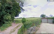
Looking ENE from Earthpits Lane in Pentridge, Dorset. Little John's Ground was the name of an area within this close / Google Earth Street View.
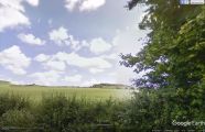
Looking SW from Whitey Top Farm in Pentridge, Dorset. Little John's Ground was the name of an area within this close / Google Earth Street View.
