Ivanhoe House (Cliftonthorpe): Difference between revisions
From International Robin Hood Bibliography
m (Text replacement - "=== Studies and criticism ===" to "=== Discussion ===") |
m (Text replacement - "VicinitySuffix=|" to "") |
||
| Line 1: | Line 1: | ||
__NOTOC__{{PnItemTop|Lat=52.7616|Lon=-1.4720|AdmDiv=Leicestershire|Vicinity=In Cliftonthorpe, in the north of Ashby-de-la-Zouch; 1 km SE of Smisby|Type=Building|Interest=Robin Hood name|Status=Defunct|Demonym=|Riding=|GreaterLondon=|Year=1886|Aka=|Century=|Cluster1=Ashby-de-la-Zouch||Cluster2=|Cluster3=|Image=ivanhoe-house-smisby-google-earth-streetview.jpg|Postcards=|ExtraCat1=Places named after Ivanhoe|ExtraCat2=|ExtraCat3=|ExtraCat4=|ExtraCat5=|ExtraLink1=|ExtraLink2=|ExtraLink3=|ExtraLink4=|ExtraLink5=|ExtraLinkName1=|ExtraLinkName2=|ExtraLinkName3=|ExtraLinkName4=|ExtraLinkName5=|GeopointPrefix=|GeopointSuffix | __NOTOC__{{PnItemTop|Lat=52.7616|Lon=-1.4720|AdmDiv=Leicestershire|Vicinity=In Cliftonthorpe, in the north of Ashby-de-la-Zouch; 1 km SE of Smisby|Type=Building|Interest=Robin Hood name|Status=Defunct|Demonym=|Riding=|GreaterLondon=|Year=1886|Aka=|Century=|Cluster1=Ashby-de-la-Zouch||Cluster2=|Cluster3=|Image=ivanhoe-house-smisby-google-earth-streetview.jpg|Postcards=|ExtraCat1=Places named after Ivanhoe|ExtraCat2=|ExtraCat3=|ExtraCat4=|ExtraCat5=|ExtraLink1=|ExtraLink2=|ExtraLink3=|ExtraLink4=|ExtraLink5=|ExtraLinkName1=|ExtraLinkName2=|ExtraLinkName3=|ExtraLinkName4=|ExtraLinkName5=|GeopointPrefix=|GeopointSuffix=|StatusSuffix=|DatePrefix=|DateSuffix=}} | ||
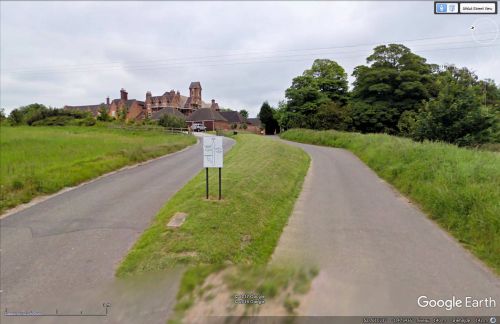
{{#display_map:{{#var:Coords}}|width=34%}}<div class="pnMapLegend">The former Ivanhoe House.</div> | {{#display_map:{{#var:Coords}}|width=34%}}<div class="pnMapLegend">The former Ivanhoe House.</div> | ||
[[File:ivanhoe-house-smisby-google-earth-streetview.jpg|thumb|right|500px|As close as we can get to the former Ivanhoe House with the Google StreetView car. The building with the tower must be the house formerly known as Ivanhoe House / Google Earth.]] | [[File:ivanhoe-house-smisby-google-earth-streetview.jpg|thumb|right|500px|As close as we can get to the former Ivanhoe House with the Google StreetView car. The building with the tower must be the house formerly known as Ivanhoe House / Google Earth.]] | ||
Revision as of 02:28, 16 December 2017
The former Ivanhoe House.
By Henrik Thiil Nielsen, 2017-05-06. Revised by Henrik Thiil Nielsen, 2017-12-16.
Immediately north of a fish pond in Cliftonthorpe, 1 km SE of Smisby, in an area that is now in the north of Ashby-de-la-Zouch, was located Ivanhoe House, according to the 6" O.S. map of the area published in 1886 but based on surveying done in 1881-82. When the map was issued in 1904 (revised 1901), Ivanhoe House no longer had a name indicated (see Maps section below).
Gazetteers
- Not included in Dobson, R. B., ed.; Taylor, J., ed. Rymes of Robyn Hood: an Introduction to the English Outlaw (London, 1976), pp. 293-311.
Maps
- 6" O.S. map Leicestershire XVI.SW (1886; surveyed 1881-82)
- 6" O.S. map Leicestershire XVI.SW (1904; rev. 1901)
- 6" O.S. map Leicestershire XVI.SW (1904; rev. 1901) (georeferenced)
- 6" O.S. map Leicestershire XVI.SW (1925; rev. 1920).
Also see

