
Eagle Barnsdale: Difference between revisions
m (→Maps) |
mNo edit summary |
||
| (13 intermediate revisions by 2 users not shown) | |||
| Line 1: | Line 1: | ||
__NOTOC__{{ | __NOTOC__{{PlaceNamesItemTop|Lat=53.178006|Lon=-0.682842|AdministrativeDivision=Lincolnshire|Vicinity=''c.'' 1.75 km SSE of Eagle; ''c.'' 1.75 km N of Morton|Type=Settlement|Interest=Miscellaneous| | ||
Status=Extant|Demonym=|Riding=|GreaterLondon=|Year= | Status=Extant|Demonym=|Riding=|GreaterLondon=|Year=1841|Aka=|Century=19|Cluster1=|Cluster2=|Cluster3=|Image=eagle-barnsdale-google-earth-street-view.jpg|Postcards=|ExtraCat1=Places named Barnsdale|ExtraCat2=|ExtraCat3=|ExtraCat4=|ExtraCat5=|ExtraLink1=|ExtraLink2=|ExtraLink3=|ExtraLink4=|ExtraLink5=|ExtraLinkName1=|ExtraLinkName2=|ExtraLinkName3=|ExtraLinkName4=|ExtraLinkName5=|GeopointPrefix=|GeopointSuffix=|VicinitySuffix=|StatusSuffix=|DatePrefix=|DateSuffix=}} | ||
{{#display_map:{{#var:Coords}}~{{#replace:{{PAGENAME}}|'|'}}|width=34% | {{#display_map:{{#var:Coords}}~{{#replace:{{PAGENAME}}|'|'}}|width=34%|enablefullscreen=yes}}<div class="pnMapLegend">Eagle Barnsdale.</div> | ||
[[File:eagle-barnsdale-google-earth-street-view.jpg|thumb|right|500px|Eagle Barnsdale / Google Earth Street View.]] | [[File:eagle-barnsdale-google-earth-street-view.jpg|thumb|right|500px|Eagle Barnsdale / Google Earth Street View.]]<div class="no-img"> | ||
<p id="byline">By Henrik Thiil Nielsen, 2017-12-27. Revised by {{#realname:{{REVISIONUSER}}}}, {{REVISIONYEAR}}-{{REVISIONMONTH}}-{{REVISIONDAY2}}.</p | <p id="byline">By Henrik Thiil Nielsen, 2017-12-27. Revised by {{#realname:{{REVISIONUSER}}}}, {{REVISIONYEAR}}-{{REVISIONMONTH}}-{{REVISIONDAY2}}.</p> | ||
A small Settlement about midway between Eagle and Morton, just east of the London North East (formerly Nottingham & Lincoln) line's tracks, in Lincolnshire's North Kesteven district, is named Eagle Barnsdale. It has lent the second part of its name to at least two localities in the vicinity: the Barnsdale Crossing (of the railway line) and the Barnsdale Farm. The earliest reference | A small Settlement about midway between Eagle and Morton, just east of the London North East (formerly Nottingham & Lincoln) line's tracks, in Lincolnshire's North Kesteven district, is named Eagle Barnsdale. It has lent the second part of its name to at least two localities in the vicinity: the Barnsdale Crossing (of the railway line) and the Barnsdale Farm. The earliest reference known to IRHB so far is a census return from 1841,<ref>[https://discovery.nationalarchives.gov.uk/details/r/C3761351 National Archives: Wapentake: Aswardhurn Parish: Evedon. Wapentake: Aswardhurn Parish: Ewerby; Hamlet:...;] [also see [https://discovery.nationalarchives.gov.uk/details/r/C3762836 National Archives: Registration District: 428. LINCOLN (Street Indexed). Registration Sub-District: 1...] (1851), and [https://discovery.nationalarchives.gov.uk/details/r/C2367767 National Archives: Eagle and Barnsdale between Thorpe-on-the-Hill and Swinderby, Lincs, accident reports.]</ref> the earliest map a 6" O.S. map of the area published in 1886 (see maps listed below). The place has no further interest in our connection than that it is one of a few places named Barnsdale (there are also a small number of localities named after one or other of these). See [[Places named Barnsdale]].{{#ask:[[Category:Records ({{PAGENAME}})]]|format=embedded|embedformat=h3|columns=1|limit=1000|sort=Utitle|intro=<h2>Records</h2><div class="mw-collapsible mw-collapsed records" data-expandtext="Show records" data-collapsetext="Hide records">|outro=</div>}} | ||
{{#ask:[[Category:Allusions ({{PAGENAME}})]]|format=embedded|embedformat=h3|columns=1|limit=1000|sort=Utitle|intro=<h2>Allusions</h2><div class="mw-collapsible mw-collapsed allusions" data-expandtext="Show allusions" data-collapsetext="Hide allusions">|outro=</div>}} | {{#ask:[[Category:Allusions ({{PAGENAME}})]]|format=embedded|embedformat=h3|columns=1|limit=1000|sort=Utitle|intro=<h2>Allusions</h2><div class="mw-collapsible mw-collapsed allusions" data-expandtext="Show allusions" data-collapsetext="Hide allusions">|outro=</div>}} | ||
== Gazetteers == | == Gazetteers == | ||
* Not included in {{:Dobson, Richard Barrie 1976a}}, pp. 293-311. | * Not included in {{:Dobson, Richard Barrie 1976a}}, pp. 293-311. | ||
== Sources == | |||
* [https://discovery.nationalarchives.gov.uk/details/r/C3761351 National Archive: Wapentake: Aswardhurn Parish: Evedon. Wapentake: Aswardhurn Parish: Ewerby; Hamlet:...] | |||
* [https://discovery.nationalarchives.gov.uk/details/r/C3762836 National Archives: Registration District: 428. LINCOLN (Street Indexed). Registration Sub-District: 1...] | |||
* [https://discovery.nationalarchives.gov.uk/details/r/C2367767 National Archives: Eagle and Barnsdale between Thorpe-on-the-Hill and Swinderby, Lincs, accident reports.] | |||
== Maps == | == Maps == | ||
| Line 22: | Line 27: | ||
* [https://www.ordnancesurvey.co.uk/getoutside/local/eagle-barnsdale-north-kesteven Ordnance Survey: Get Outside: Eagle Barnsdale, North Kesteven] | * [https://www.ordnancesurvey.co.uk/getoutside/local/eagle-barnsdale-north-kesteven Ordnance Survey: Get Outside: Eagle Barnsdale, North Kesteven] | ||
* [https://en.wikipedia.org/wiki/Eagle_Barnsdale Wikipedia: Eagle Barnsdale.] | * [https://en.wikipedia.org/wiki/Eagle_Barnsdale Wikipedia: Eagle Barnsdale.] | ||
{{PlaceNamesItemAlsoSee}} | |||
== Notes == | |||
<references/> | |||
</div> | |||
<div id="gallery"> | |||
{{ImageGalleryIntroduction}} | |||
< | |||
{{ | |||
<gallery widths="195px"> | <gallery widths="195px"> | ||
File:eagle-barnsdale-google-earth-street-view.jpg|Eagle Barnsdale / Google Earth Street View. | File:eagle-barnsdale-google-earth-street-view.jpg|Eagle Barnsdale / Google Earth Street View. | ||
| Line 32: | Line 39: | ||
File:361335_58ca597c.jpg|Eagle Barnsdale Level Crossing / [http://www.geograph.org.uk/photo/361335 Richard Croft, 11 Mar. 2007, Creative Commons, via Geograph.] | File:361335_58ca597c.jpg|Eagle Barnsdale Level Crossing / [http://www.geograph.org.uk/photo/361335 Richard Croft, 11 Mar. 2007, Creative Commons, via Geograph.] | ||
</gallery> | </gallery> | ||
</div> | |||
{{PlaceNamesItemNavigation}} | |||
{{ | |||
Latest revision as of 11:33, 13 February 2021
| Locality | |
|---|---|
| Coordinate | 53.178006, -0.682842 |
| Adm. div. | Lincolnshire |
| Vicinity | c. 1.75 km SSE of Eagle; c. 1.75 km N of Morton |
| Type | Settlement |
| Interest | Miscellaneous |
| Status | Extant |
| First Record | 1841 |

By Henrik Thiil Nielsen, 2017-12-27. Revised by Henrik Thiil Nielsen, 2021-02-13.
A small Settlement about midway between Eagle and Morton, just east of the London North East (formerly Nottingham & Lincoln) line's tracks, in Lincolnshire's North Kesteven district, is named Eagle Barnsdale. It has lent the second part of its name to at least two localities in the vicinity: the Barnsdale Crossing (of the railway line) and the Barnsdale Farm. The earliest reference known to IRHB so far is a census return from 1841,[1] the earliest map a 6" O.S. map of the area published in 1886 (see maps listed below). The place has no further interest in our connection than that it is one of a few places named Barnsdale (there are also a small number of localities named after one or other of these). See Places named Barnsdale.
Gazetteers
- Not included in Dobson, R. B., ed.; Taylor, J., ed. Rymes of Robyn Hood: an Introduction to the English Outlaw (London, 1976), pp. 293-311.
Sources
- National Archive: Wapentake: Aswardhurn Parish: Evedon. Wapentake: Aswardhurn Parish: Ewerby; Hamlet:...
- National Archives: Registration District: 428. LINCOLN (Street Indexed). Registration Sub-District: 1...
- National Archives: Eagle and Barnsdale between Thorpe-on-the-Hill and Swinderby, Lincs, accident reports.
Maps
- 25" O.S. map Lincolnshire LXXVII.7 (1887; surveyed 1886)
- 25" O.S. map Lincolnshire LXXVII.7 (1905; surveyed 1904)
- 6" O.S. map Lincolnshire LXXVII.NE (1886; surveyed 1886)
- 6" O.S. map Lincolnshire LXXVII.NE (1906; rev. 1904)
- 6" O.S. map Lincolnshire LXXVII.NE (1906; rev. 1904) (georeferenced)
- 6" O.S. map Lincolnshire LXXVII.NE (c. 1933; rev. 1904)
- 6" O.S. map Lincolnshire LXXVII.NE (1950; rev. 1948).
Background
- The ABC Railway Guide: Eagle Barnsdale Level Crossing
- Ordnance Survey: Get Outside: Eagle Barnsdale, North Kesteven
- Wikipedia: Eagle Barnsdale.
Also see
Notes
- ↑ National Archives: Wapentake: Aswardhurn Parish: Evedon. Wapentake: Aswardhurn Parish: Ewerby; Hamlet:...; [also see National Archives: Registration District: 428. LINCOLN (Street Indexed). Registration Sub-District: 1... (1851), and National Archives: Eagle and Barnsdale between Thorpe-on-the-Hill and Swinderby, Lincs, accident reports.
Image gallery
Click any image to display it in the lightbox, where you can navigate between images by clicking in the right or left side of the current image.
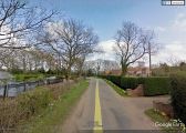
Eagle Barnsdale / Google Earth Street View.
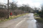
Street scene in Eagle Barnsdale / Roger Geach, 16 Feb. 2010, Creative Commons, via Geograph.
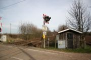
Eagle Barnsdale Level Crossing / Richard Croft, 11 Mar. 2007, Creative Commons, via Geograph.

