
Robin Hood (Leigh)
| Locality | |
|---|---|
| Coordinate | 53.481241, -2.537178 |
| Adm. div. | Lancashire |
| Vicinity | 257 St Helens Road, Leigh, Wigan |
| Type | Public house |
| Interest | Robin Hood name |
| Status | Extant |
| First Record | |
| A.k.a. | Robin Hood Pub Food |

By Henrik Thiil Nielsen, 2013-08-07. Revised by Henrik Thiil Nielsen, 2021-02-13.
The still existing Robin Hood pub on 257 St Helens Road, Aspull Common, Leigh, Lancashire, seems to be of early 20th or late 19th century date. It can be regarded as a successor to another pub of the same name which was situated a few tens of metres south of it and continued life as Robin Hood Farm after it ceased to function as a public house.
Gazetteers
- Not included in Dobson, R. B., ed.; Taylor, J., ed. Rymes of Robyn Hood: an Introduction to the English Outlaw (London, 1976), pp. 315-19.
Maps
- 25" O.S. map Lancashire CII.10 (c. 1893; surveyed c. 1891). No copy in NLS
- 25" O.S. map Lancashire CII.10 (1907; rev. 1905)
- 25" O.S. map Lancashire XLIII.12 (1912; rev. 1910) (georeferenced)
- 25" O.S. map Lancashire CII.10 (1928; rev. 1925)
- 6" O.S. map Lancashire CII (1849; surveyed 1845–47)
- 6" O.S. map Lancashire CII.SW (1894; surveyed 1891–92)
- 6" O.S. map Lancashire CII.SW (1908; rev. 1905–06) (georeferenced)
- 6" O.S. map Lancashire CII.SW (1929; rev. 1925)
- 6" O.S. map Lancashire CII.SW (1947; rev. 1938)
- 6" O.S. map Lancashire CII.SW (1951; rev. 1947).
Background
Also see
Image gallery
Click any image to display it in the lightbox, where you can navigate between images by clicking in the right or left side of the current image.
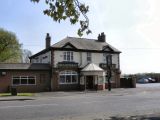
Robin Hood, St Helens Road / David Dixon, 19 Apr. 2011; Creative Commons, via Geograph.
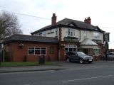
The Robin Hood pub on St Helens Road / J. Thomas, 2 Mar. 2013; Creative Commons, via Geograph
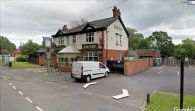
The Robin Hood / Google Earth Street View.

