
Sherwood House (Clapham): Difference between revisions
From International Robin Hood Bibliography
(Created page with "__NOTOC__{{PlaceNamesItemTop|Lat=54.112092|Lon=-2.456002|AdministrativeDivision=Yorkshire|Vicinity=''c.'' 3.3 km E of Bentham; ''c.'' 4.2 km W of Clapham|Type=Building|Interes...") |
mNo edit summary |
||
| Line 1: | Line 1: | ||
__NOTOC__{{PlaceNamesItemTop|Lat=54.112092|Lon=-2.456002|AdministrativeDivision=Yorkshire|Vicinity=''c.'' 3.3 km E of Bentham; ''c.'' 4.2 km W of Clapham|Type=Building|Interest=Robin Hood name|Status=Extant|Demonym=|Riding=West|GreaterLondon=|Year=|Aka=|Century=|Cluster1=Bentham|Cluster2=|Cluster3=|Image=geograph-172720-by-Michael-Graham.jpg|Postcards=|ExtraCat1=Places named | __NOTOC__{{PlaceNamesItemTop|Lat=54.112092|Lon=-2.456002|AdministrativeDivision=Yorkshire|Vicinity=''c.'' 3.3 km E of Bentham; ''c.'' 4.2 km W of Clapham|Type=Building|Interest=Robin Hood name|Status=Extant|Demonym=|Riding=West|GreaterLondon=|Year=|Aka=|Century=|Cluster1=Bentham|Cluster2=|Cluster3=|Image=geograph-172720-by-Michael-Graham.jpg|Postcards=|ExtraCat1=Places named after Sherwood Forest|ExtraCat2=|ExtraCat3=|ExtraCat4=|ExtraCat5=|GeopointPrefix=|GeopointSuffix=|StatusSuffix=?|DatePrefix=|DateSuffix=}} | ||
{{#display_map:{{#var:Coords}}~{{#replace:{{PAGENAME}}|'|'}}|width=34%|enablefullscreen=yes}}<div class="pnMapLegend">Butt Hill or Robin Hood Butts, about midway between Bentham and Clapham in Craven.</div> | {{#display_map:{{#var:Coords}}~{{#replace:{{PAGENAME}}|'|'}}|width=34%|enablefullscreen=yes}}<div class="pnMapLegend">Butt Hill or Robin Hood Butts, about midway between Bentham and Clapham in Craven.</div> | ||
[[File:{{#var:Image}}|500px|thumb|right| | [[File:{{#var:Image}}|500px|thumb|right|Sign reading 'Sherwood', front right; Sherwood House must be just beyond and below the hill / [https://m.geograph.org.uk/photo/172720 Michael Graham, 21 May 2006, Creative Commons, via Geograph.]]] | ||
<div class="no-img"> | <div class="no-img"> | ||
<p id="byline">By Henrik Thiil Nielsen, 2014-09-05. Revised by {{#realname:{{REVISIONUSER}}}}, {{REVISIONYEAR}}-{{REVISIONMONTH}}-{{REVISIONDAY2}}.</p> | <p id="byline">By Henrik Thiil Nielsen, 2014-09-05. Revised by {{#realname:{{REVISIONUSER}}}}, {{REVISIONYEAR}}-{{REVISIONMONTH}}-{{REVISIONDAY2}}.</p> | ||
Formerly in the West Riding of Yorkshire, the area where the hill is situated now belongs administratively to North Yorkshire. | Formerly in the West Riding of Yorkshire, the area where the hill is situated now belongs administratively to North Yorkshire. | ||
{{PlaceNamesItemAllusionsAndRecords}} | {{PlaceNamesItemAllusionsAndRecords}} | ||
== Maps == | == Maps == | ||
* [https://maps.nls.uk/view/125631832#zoom=4&lat=5697&lon=11091&layers=BT 25" O.S. map ''Yorkshire'' CXIII.9 (1894; surveyed 1893)] | * [https://maps.nls.uk/view/125631832#zoom=4&lat=5697&lon=11091&layers=BT 25" O.S. map ''Yorkshire'' CXIII.9 (1894; surveyed 1893)] | ||
* [https://maps.nls.uk/view/125631835#zoom=5&lat=5373&lon=11577&layers=BT 25" O.S. map ''Yorkshire'' CXIII.9 (1909; rev. 1907)] | * [https://maps.nls.uk/view/125631835#zoom=5&lat=5373&lon=11577&layers=BT 25" O.S. map ''Yorkshire'' CXIII.9 (1909; rev. 1907)] | ||
| Line 22: | Line 18: | ||
== Gazetteers == | == Gazetteers == | ||
* Not included in {{:Dobson, Richard Barrie 1976a}}, pp. 293-311. | * Not included in {{:Dobson, Richard Barrie 1976a}}, pp. 293-311. | ||
{{PlaceNamesItemAlsoSee}} | {{PlaceNamesItemAlsoSee}} | ||
== Notes == | == Notes == | ||
| Line 39: | Line 26: | ||
{{ImageGalleryIntroduction}} | {{ImageGalleryIntroduction}} | ||
<gallery widths="195px"> | <gallery widths="195px"> | ||
geograph-172720-by-Michael-Graham.jpg| | geograph-172720-by-Michael-Graham.jpg|Sign reading 'Sherwood', front right; Sherwood House must be just beyond and below the hill / [https://m.geograph.org.uk/photo/172720 Michael Graham, 21 May 2006, Creative Commons, via Geograph.] | ||
sherwood-house-clapham-google-earth-street-view.jpg|Sherwood House is situated ''c.'' 450 m SE of Robin Hood Buyts (Clapham) / Google Earth. | |||
Sherwood House (Clapham) | |||
</gallery> | </gallery> | ||
{{PlaceNamesItemNavigation}} | {{PlaceNamesItemNavigation}} | ||
Revision as of 00:52, 30 May 2021
| Locality | |
|---|---|
| Coordinate | 54.112092, -2.456002 |
| Adm. div. | West Riding of Yorkshire |
| Vicinity | c. 3.3 km E of Bentham; c. 4.2 km W of Clapham |
| Type | Building |
| Interest | Robin Hood name |
| Status | Extant? |
| First Record | |
Butt Hill or Robin Hood Butts, about midway between Bentham and Clapham in Craven.

Sign reading 'Sherwood', front right; Sherwood House must be just beyond and below the hill / Michael Graham, 21 May 2006, Creative Commons, via Geograph.
By Henrik Thiil Nielsen, 2014-09-05. Revised by Henrik Thiil Nielsen, 2021-05-30.
Formerly in the West Riding of Yorkshire, the area where the hill is situated now belongs administratively to North Yorkshire.
Maps
- 25" O.S. map Yorkshire CXIII.9 (1894; surveyed 1893)
- 25" O.S. map Yorkshire CXIII.9 (1909; rev. 1907)
- 25" O.S. map Bentham parish, Yorkshire (1950s) (georeferenced)
- 6" O.S. map Yorkshire 113 (1851; surveyed 1846–47)
- 6" O.S. map Yorkshire CXIII (1896; surveyed 1893)
- 6" O.S. map Yorkshire CXIII.SW (1910; rev. 1907) (georeferenced)
- 6" O.S. map Yorkshire CXIII.SW (1910; rev. 1907).
Gazetteers
- Not included in Dobson, R. B., ed.; Taylor, J., ed. Rymes of Robyn Hood: an Introduction to the English Outlaw (London, 1976), pp. 293-311.
Also see
Notes
Image gallery
Click any image to display it in the lightbox, where you can navigate between images by clicking in the right or left side of the current image.
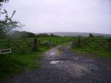
Sign reading 'Sherwood', front right; Sherwood House must be just beyond and below the hill / Michael Graham, 21 May 2006, Creative Commons, via Geograph.
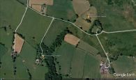
Sherwood House is situated c. 450 m SE of Robin Hood Buyts (Clapham) / Google Earth.
