
Robinhood Lane (Winnersh): Difference between revisions
mNo edit summary |
mNo edit summary |
||
| Line 6: | Line 6: | ||
Robinhood Lane in Winnersh runs north-east from Reading Road to become Davis Street north of the A329 (M) overpass. | Robinhood Lane in Winnersh runs north-east from Reading Road to become Davis Street north of the A329 (M) overpass. | ||
Until sometime in the latter half of the 20th century, the road followed a less direct course than it does at present. North of Arbor Lane, it turned NNE, following the course of the present [[Robin Hood Way (Winnersh)|Robin Hood Way]]. See this for further discussion of changes to the course of the road. The earliest source to include the road name known to IRHB is a 6" O.S. map dating from 1883 (see below). The English Place-Name Society's volume on this part of Berkshire conflates it with [[Robin Hoods (Winnersh) (1)|Robin Hoods]] and [[Robin Hoods Ground (Winnersh)|Robin Hoods Ground]], citing no date for Robinhood Lane.<ref>{{:Gelling, Margaret 1973a}}, pt. I, pp. 124, 137, 138, 285.</ref>{{PnItemQry}} | Until sometime in the latter half of the 20th century, the road followed a less direct course than it does at present. North of Arbor Lane, it turned NNE, following the course of the present [[Robin Hood Way (Winnersh)|Robin Hood Way]]. See this for further discussion of changes to the course of the road. The earliest source to include the road name known to IRHB is a 6" O.S. map dating from 1883 (see below). The English Place-Name Society's volume on this part of Berkshire conflates it with [[Robin Hoods (Winnersh) (1)|Robin Hoods]] and [[Robin Hoods Ground (Winnersh)|Robin Hoods Ground]], citing no date for Robinhood Lane.<ref>{{:Gelling, Margaret 1973a}}, pt. I, pp. 124, 137, 138, 285.</ref> | ||
=== Robin Hood's Arbour?=== | |||
Margaret Gelling, the editor of the English Place-Name Society's volumes on Berkshire, suggests that the names of Robinhood Lane, the [[Robin Hoods (Winnersh)|Robin Hoods]] and [[Robin Hoods Ground (Winnersh)|Robin Hoods Ground]] in Winnersh may preserve the memory of a lost Robin Hood's Arbour. She notes that there is an Arbour Cottage near Robinhood Lane. "The Arbor" figures in an early 17th century survey and (presumably) again in an 1843 enclosure award as "The Harbour". There is currently an Arbor Lane in the vicinity. She further cites a "Robynpriserber" recorded in 1579 and notes that there is a [[Robin Hood's Arbour (Maidenhead)|Robin Hood's Arbour in Maidenhead]].<ref>{{:Gelling, Margaret 1973a}}, pt. I, pp. 137, 138, and pp. xii, xviii for expansions of source references.</ref> | |||
{{PnItemQry}} | |||
== Gazetteers == | == Gazetteers == | ||
* Not included in {{:Dobson, Richard Barrie 1976a|Dobson & Taylor}}, pp. 293-311. | * Not included in {{:Dobson, Richard Barrie 1976a|Dobson & Taylor}}, pp. 293-311. | ||
| Line 34: | Line 37: | ||
<!--== Discussion ==--> | <!--== Discussion ==--> | ||
== Background == | == Background == | ||
* {{:Gelling, Margaret 1973a}}, pt. I, pp. 137, 138, and pp. xii, xviii for expansions of source references | |||
* [https://en.wikipedia.org/wiki/Winnersh Wikipedia: Winnersh.] | * [https://en.wikipedia.org/wiki/Winnersh Wikipedia: Winnersh.] | ||
<!--== Brief mention ==--> | <!--== Brief mention ==--> | ||
Revision as of 04:25, 22 September 2018
[[File:|thumb|right|500px|Robinhood Lane, Winnersh / Google Maps Street View.]]

By Henrik Thiil Nielsen, 2018-05-28. Revised by Henrik Thiil Nielsen, 2018-09-22.
Robinhood Lane in Winnersh runs north-east from Reading Road to become Davis Street north of the A329 (M) overpass.
Until sometime in the latter half of the 20th century, the road followed a less direct course than it does at present. North of Arbor Lane, it turned NNE, following the course of the present Robin Hood Way. See this for further discussion of changes to the course of the road. The earliest source to include the road name known to IRHB is a 6" O.S. map dating from 1883 (see below). The English Place-Name Society's volume on this part of Berkshire conflates it with Robin Hoods and Robin Hoods Ground, citing no date for Robinhood Lane.[1]
Robin Hood's Arbour?
Margaret Gelling, the editor of the English Place-Name Society's volumes on Berkshire, suggests that the names of Robinhood Lane, the Robin Hoods and Robin Hoods Ground in Winnersh may preserve the memory of a lost Robin Hood's Arbour. She notes that there is an Arbour Cottage near Robinhood Lane. "The Arbor" figures in an early 17th century survey and (presumably) again in an 1843 enclosure award as "The Harbour". There is currently an Arbor Lane in the vicinity. She further cites a "Robynpriserber" recorded in 1579 and notes that there is a Robin Hood's Arbour in Maidenhead.[2] Template:PnItemQry
Gazetteers
- Not included in Dobson, R. B., ed.; Taylor, J., ed. Rymes of Robyn Hood: an Introduction to the English Outlaw (London, 1976), pp. 293-311.
Sources
- Gelling, Margaret. The Place-Names of Berkshire (English Place-Name Society, vols. XLIX-LI) (Cambridge, 1973; [s.l.], 1974-76), pt. I, pp. 124, 137, 138, 285.
Maps
- 25" O.S. map Berkshire XXXVIII.6 (c. 1875; surveyed 1871). No Copy in NLS
- 25" O.S. map Berkshire XXXVIII.6 (1899; rev. 1898)
- 25" O.S. map Berkshire XXXVIII.10 (1899; rev. 1898)
- 25" O.S. map Berkshire XXXVIII.6 (1899; rev. 1898) (georeferenced)
- 25" O.S. map Berkshire XXXVIII.10 (1911; rev. 1909)
- 25" O.S. map Berkshire XXXVIII.6 (1912; rev. 1910)
- 25" O.S. map Berkshire XXXVIII.10 (1933; rev. 1931).
- 25" O.S. map Berkshire XXXVIII.6 (1933; rev. 1932)
- 6" O.S. map Berkshire XXXVIII (1883; surveyed 1871-72)
- 6" O.S. map Berkshire XXXVIII.NW (1900; rev. 1898)
- 6" O.S. map Berkshire XXXVIII.SW (1900; rev. 1898)
- 6" O.S. map Berkshire XXXVIII.NW (1900; rev. 1898) (georeferenced)
- 6" O.S. map Berkshire XXXVIII.SW (1912; rev. 1909)
- 6" O.S. map Berkshire XXXVIII.NW (1913; rev. 1910)
- 6" O.S. map Berkshire XXXVIII.SW (c. 1933; rev. 1931-32)
- 6" O.S. map Berkshire XXXVIII.NW (c. 1934; rev. 1932)
- 6" O.S. map Berkshire XXXVIII.SW (c. 1944; rev. 1931-32).
- 6" O.S. map Berkshire XXXVIII.NW (c. 1944; rev. 1938)
- 1" O.S. New Pop. Ed. Sheet 169 (Hills) (1946).
- 1" O.S. map Aldershot (7th Ser.) (1959; surveyed 1956-59) (georeferenced)
Background
- Gelling, Margaret. The Place-Names of Berkshire (English Place-Name Society, vols. XLIX-LI) (Cambridge, 1973; [s.l.], 1974-76), pt. I, pp. 137, 138, and pp. xii, xviii for expansions of source references
- Wikipedia: Winnersh.
Notes
- ↑ Gelling, Margaret. The Place-Names of Berkshire (English Place-Name Society, vols. XLIX-LI) (Cambridge, 1973; [s.l.], 1974-76), pt. I, pp. 124, 137, 138, 285.
- ↑ Gelling, Margaret. The Place-Names of Berkshire (English Place-Name Society, vols. XLIX-LI) (Cambridge, 1973; [s.l.], 1974-76), pt. I, pp. 137, 138, and pp. xii, xviii for expansions of source references.
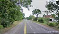
Robinhood Lane, Winnersh / Google Maps Street View.
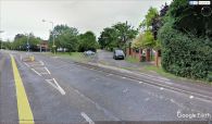
Formerly Robinhood Lane turned NNE here along the course of the present Robin Hood Way, now separated from it by a bit of railing and a narrow foot walk / Google Maps Street View.

