
Robinhood Lane (Winnersh): Difference between revisions
mNo edit summary |
mNo edit summary |
||
| Line 42: | Line 42: | ||
File:robin-hood-lane-winnersh-google-maps-street-view.jpg|thumb|right|500px|Robinhood Lane, Winnersh / Google Maps Street View. | File:robin-hood-lane-winnersh-google-maps-street-view.jpg|thumb|right|500px|Robinhood Lane, Winnersh / Google Maps Street View. | ||
File:robin-hood-way-winnersh-google-maps-street-view-2.jpg|thumb|right|500px|Formerly Robinhood Lane turned NNE here along the course of the present Robin Hood Way, now separated from it by a bit of railing and a narrow foot walk / Google Maps Street View. | File:robin-hood-way-winnersh-google-maps-street-view-2.jpg|thumb|right|500px|Formerly Robinhood Lane turned NNE here along the course of the present Robin Hood Way, now separated from it by a bit of railing and a narrow foot walk / Google Maps Street View. | ||
File:H G R 19xxa-r.jpg|[[H G R|H.G.R. ''Robin Hood Lane, Winnersh'' (H.G.R., II) ([''s.l.''], [''s.d.'']). Photographic postcard (monochrome), 140 x 86 mm.]] / Private collection. | |||
</gallery> | </gallery> | ||
{{PnItemNav}} | {{PnItemNav}} | ||
Revision as of 00:20, 11 July 2018
[[File:|thumb|right|500px|Robinhood Lane, Winnersh / Google Maps Street View.]]

By Henrik Thiil Nielsen, 2018-05-28. Revised by Henrik Thiil Nielsen, 2018-07-11.
Robinhood Lane in Winnersh runs north-east from Reading Road to become Davis Street north of the A329 (M) overpass.
Until sometime in the latter half of the 20th century, the road followed a less direct course than it does at present. North of Arbor Lane, it turned NNE, following the course of the present Robin Hood Way. See this for further discussion of changes to the course of the road. The earliest O.S. map I have seen to include the road name is a 6" map dating from 1883 (see below).
Maps
- 25" O.S. map Berkshire XXXVIII.6 (c. 1875; surveyed 1871). No Copy in NLS
- 25" O.S. map Berkshire XXXVIII.6 (1899; rev. 1898)
- 25" O.S. map Berkshire XXXVIII.10 (1899; rev. 1898)
- 25" O.S. map Berkshire XXXVIII.6 (1899; rev. 1898) (georeferenced)
- 25" O.S. map Berkshire XXXVIII.10 (1911; rev. 1909)
- 25" O.S. map Berkshire XXXVIII.6 (1912; rev. 1910)
- 25" O.S. map Berkshire XXXVIII.10 (1933; rev. 1931).
- 25" O.S. map Berkshire XXXVIII.6 (1933; rev. 1932)
- 6" O.S. map Berkshire XXXVIII (1883; surveyed 1871-72)
- 6" O.S. map Berkshire XXXVIII.NW (1900; rev. 1898)
- 6" O.S. map Berkshire XXXVIII.SW (1900; rev. 1898)
- 6" O.S. map Berkshire XXXVIII.NW (1900; rev. 1898) (georeferenced)
- 6" O.S. map Berkshire XXXVIII.SW (1912; rev. 1909)
- 6" O.S. map Berkshire XXXVIII.NW (1913; rev. 1910)
- 6" O.S. map Berkshire XXXVIII.SW (c. 1933; rev. 1931-32)
- 6" O.S. map Berkshire XXXVIII.NW (c. 1934; rev. 1932)
- 6" O.S. map Berkshire XXXVIII.SW (c. 1944; rev. 1931-32).
- 6" O.S. map Berkshire XXXVIII.NW (c. 1944; rev. 1938)
- 1" O.S. New Pop. Ed. Sheet 169 (Hills) (1946).
- 1" O.S. map Aldershot (7th Ser.) (1959; surveyed 1956-59) (georeferenced)
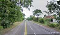
Robinhood Lane, Winnersh / Google Maps Street View.
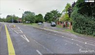
Formerly Robinhood Lane turned NNE here along the course of the present Robin Hood Way, now separated from it by a bit of railing and a narrow foot walk / Google Maps Street View.

