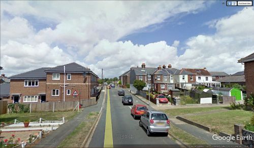
Robin Hood Street (Newport)
From International Robin Hood Bibliography
| Locality | |
|---|---|
| Coordinate | 50.698923, -1.286676 |
| Adm. div. | Hampshire |
| Vicinity | Connecting Barton Road and Furlongs |
| Type | Thoroughfare |
| Interest | Robin Hood name |
| Status | Extant |
| First Record | 1908 |
Robin Hood Street, Newport, Isle of Wight.
By Henrik Thiil Nielsen, 2018-10-27. Revised by Henrik Thiil Nielsen, 2021-02-13.
Robin Hood Street in Newport, Isle of Wight, connects Barton Road and Furlongs. It must take its name from the Robin Hood pub there, which closed in 2014 or later. The earliest references to the street name currently known to IRHB are the 25" O.S. map from 1908 and the 6" O.S, map from 1909 listed below.
Gazetteers
- Not included in Dobson, R. B., ed.; Taylor, J., ed. Rymes of Robyn Hood: an Introduction to the English Outlaw (London, 1976), pp. 315-19.
Maps
- 25" O.S. map Hampshire and Isle of Wight XCV.2 (c. 1865; surveyed 1862). No copy in NLS
- 25" O.S. map Hampshire and Isle of Wight XCV.2 (c. 1898; rev. c. 1896). No copy in NLS
- 25" O.S. map Hampshire and Isle of Wight XCV.2 (1908; rev. 1907) (georeferenced)
- 25" O.S. map Hampshire and Isle of Wight XCV.2 (1908; rev. 1907)
- 6" O.S. map Hampshire & Isle of Wight XCV (1866; surveyed 1863)
- 6" O.S. map Hampshire & Isle of Wight XCV.NW (1898; rev. 1896) (georeferenced)
- 6" O.S. map Hampshire & Isle of Wight XCV.NW (1898; rev. 1896)
- 6" O.S. map Hampshire & Isle of Wight XCV.NW (1909; rev. 1906-1907)
- 6" O.S. map Hampshire & Isle of Wight XCV.NW (c. 1947; rev. 1938).
Also see

