|
|
| Line 1: |
Line 1: |
| __NOTOC__ | | __NOTOC__{{PnItemTop|Lat=53.7396|Lon=-1.5059|AdmDiv=Yorkshire|Vicinity=In village of Robin Hood, Wakefield|Type=Transport|Interest=Robin Hood name|Status=Defunct|Demonym=|Riding=West|GreaterLondon=|Year=1894|Aka=|Century=|Cluster1=|Cluster2=|Cluster3=|Image=robin-hood-sidings-robin-hood-wakefield-google-earth.jpg|Postcards=|ExtraCat1=|ExtraCat2=|ExtraCat3=|ExtraCat4=|ExtraCat5=|GeopointPrefix=|GeopointSuffix=|VicinitySuffix=|StatusSuffix=|DatePrefix=|DateSuffix=}} |
| {{Infobox
| | {{#display_map:{{#var:Coords}}|width=34%}}<div class="pnMapLegend">Site of Robin Hood Sidings.</div> |
| |header1=Locality
| |
| |label2=Coordinates
| |
| |data2=[[Geopoint::53.7396,-1.5059]]
| |
| |label3=Adm. div.
| |
| |data3=[[pnadmdiv::West Riding of Yorkshire]]
| |
| |label4=Vicinity
| |
| |data4=[[pnvicinity::In village of Robin Hood, Wakefield]]
| |
| |label5=Type
| |
| |data5=[[pntype::Transport]]
| |
| |label6=Interest
| |
| |data6=[[pninterest::Robin Hood name]]
| |
| |label7=Status
| |
| |data7=[[pnstatus::Defunct]]
| |
| |label8=First Record
| |
| |data8=[[pnfirstrecord::1894]]
| |
| }} | |
| {{#display_map:53.7396,-1.5059|width=34%}}<div class="pnMapLegend">Site of Robin Hood Sidings.</div> | |
| [[File:robin-hood-sidings-robin-hood-wakefield-google-earth.jpg|thumb|right|500px|This area once was full of railway tracks. The streets here are named Farrier Way, Goldsmith Drive etc. I wonder why 'Robin Hood Sidings' was not kept?]] | | [[File:robin-hood-sidings-robin-hood-wakefield-google-earth.jpg|thumb|right|500px|This area once was full of railway tracks. The streets here are named Farrier Way, Goldsmith Drive etc. I wonder why 'Robin Hood Sidings' was not kept?]] |
| <p id="byline">By Henrik Thiil Nielsen, 2016-12-31. Revised by {{#realname:{{REVISIONUSER}}}}, {{REVISIONYEAR}}-{{REVISIONMONTH}}-{{REVISIONDAY2}}.</p><div class="no-img"> | | <p id="byline">By Henrik Thiil Nielsen, 2016-12-31. Revised by {{#realname:{{REVISIONUSER}}}}, {{REVISIONYEAR}}-{{REVISIONMONTH}}-{{REVISIONDAY2}}.</p><div class="no-img"> |
| Line 41: |
Line 24: |
|
| |
|
|
| |
|
| </div> | | </div><!-- |
| <div id="dplcatlinks" class="subcategory"><div id="dplcatarea"> | | {{ImgGalleryIntro}} |
| {{#ask: [[Category:English place-names]]
| | <gallery widths="195px"> |
| [[Category:West Riding of Yorkshire place-names]][[Utitle::<<{{#replace:{{uc:{{PAGENAME}}}}|'|'}}]]|order=descending|searchlabel=|format=template|introtemplate=BeforeNav|template=Nav|outrotemplate=Previous|link=none|limit=1|sort=Utitle}}[[West Riding of Yorkshire place-names]]{{#ask: [[Category:English place-names]]
| | FOR EACH IMAGE: File:_FILENAME.jpg|_LEGEND / [_URL _PHOTOGRAPHER, _DAY _MON. _YEAR, Creative Commons.] |
| [[Category:West Riding of Yorkshire place-names]][[Utitle::>>{{#replace:{{uc:{{PAGENAME}}}}|'|'}}]]|order=ascending|searchlabel=|format=template|introtemplate=BeforeNav|template=Nav|outrotemplate=Next|link=none|limit=1|sort=Utitle}}
| | </gallery>--> |
|
| |
|
| <p>{{#ask: [[Category:English place-names]][[Utitle::<<{{#replace:{{uc:{{PAGENAME}}}}|'|'}}]]|order=descending|searchlabel=|format=template|introtemplate=BeforeNav|template=Nav|outrotemplate=Previous|link=none|limit=1|sort=Utitle}}[[Yorkshire place-names]]{{#ask: [[Category:English place-names]][[Utitle::>>{{#replace:{{uc:{{PAGENAME}}}}|'|'}}]]|order=ascending|searchlabel=|format=template|introtemplate=BeforeNav|template=Nav|outrotemplate=Next|link=none|limit=1|sort=Utitle}}</p>
| | {{PnItemNav}} |
| | |
| {{#ask: [[Category:English place-names]][[Utitle::<<{{#replace:{{uc:{{PAGENAME}}}}|'|'}}]]|order=descending|searchlabel=|format=template|introtemplate=BeforeNav|template=Nav|outrotemplate=Previous|link=none|limit=1|sort=Utitle}}[[Place-names]]{{#ask: [[Category:English place-names]][[Utitle::>>{{#replace:{{uc:{{PAGENAME}}}}|'|'}}]]|order=ascending|searchlabel=|format=template|introtemplate=BeforeNav|template=Nav|outrotemplate=Next|link=none|limit=1|sort=Utitle}}</div></div>
| |
| [[Category:English place-names]]
| |
| [[Category:West Riding of Yorkshire place-names]]
| |
| [[Category:Place-names-topics]]
| |
| [[Category:Robin Hood place-name cluster]]
| |
| [[Category:Wakefield place-name cluster]]
| |
| [[Category:19th century]]
| |
| {{#set:century=19th}}
| |
| {{#set:Utitle={{#replace:{{uc:{{PAGENAME}}}}|'|'}}}}
| |
| {{#set:Pnimage=robin-hood-sidings-robin-hood-wakefield-google-earth.jpg}}
| |
| {{#set:Pnimage=robin-hood-sidings-robin-hood-wakefield-google-earth.jpg}}
| |
Template:PnItemTop
Loading map...
{"minzoom":false,"maxzoom":false,"mappingservice":"leaflet","width":"34%","height":"400px","centre":false,"title":"","label":"","icon":"","lines":[],"polygons":[],"circles":[],"rectangles":[],"copycoords":false,"static":false,"zoom":false,"defzoom":9,"layers":["OpenStreetMap","NLS","Stamen.Terrain"],"image layers":[],"overlays":[],"resizable":false,"fullscreen":false,"scrollwheelzoom":true,"cluster":false,"clustermaxzoom":20,"clusterzoomonclick":true,"clustermaxradius":80,"clusterspiderfy":true,"geojson":"","clicktarget":"","imageLayers":[],"locations":[],"imageoverlays":null}
Site of Robin Hood Sidings.
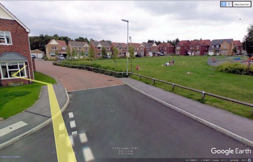
This area once was full of railway tracks. The streets here are named Farrier Way, Goldsmith Drive etc. I wonder why 'Robin Hood Sidings' was not kept?
By Henrik Thiil Nielsen, 2016-12-31. Revised by Henrik Thiil Nielsen, 2017-12-06.
Robin Hood Sidings in the village of Robin Hood, Wakefield, on the East and West Yorkshire Union Railway, are first recorded, as far as I know, on the 6" O.S. map of the area published in 1894. The railway was established in 1891 and extended a few years later. It closed in 1966.[1]
Maps
Background
Also see
Notes
Template:PnItemNav

