
Robin Hood Lane (Sutton): Difference between revisions
From International Robin Hood Bibliography
mNo edit summary |
mNo edit summary |
||
| Line 5: | Line 5: | ||
|data2=[[Geopoint::{{#var:Coords}}]] | |data2=[[Geopoint::{{#var:Coords}}]] | ||
|label3=Adm. div. | |label3=Adm. div. | ||
|data3=[[pnadmdiv::{{ | |data3=[[pnadmdiv::{{{County}}}]] | ||
|label4=Vicinity | |label4=Vicinity | ||
|data4 = [[pnvicinity::Connecting St James's Road and Collingwood Road]] | |data4 = [[pnvicinity::Connecting St James's Road and Collingwood Road]] | ||
Revision as of 23:11, 30 November 2017
| Locality | |
|---|---|
| Coordinates | |
| Adm. div. | {{{County}}}Property "Pnadmdiv" (as page type) with input value "{{{County}}}" contains invalid characters or is incomplete and therefore can cause unexpected results during a query or annotation process. |
| Vicinity | Connecting St James's Road and Collingwood Road |
| Type | Thoroughfare |
| Interest | Robin Hood name |
| Status | Extant |
| First Record | |
| A.k.a | |
Robin Hood Lane, Sutton.
[[File:|500px|thumb|right|Robin Hood Lane, Sutton / Google Earth Street View.]]
By Henrik Thiil Nielsen, 2013-08-07. Revised by Henrik Thiil Nielsen, 2017-11-30.
Robin Hood Lane is a residential street in Sutton, Surrey. The earliest reference I have is a 6" O.S. map of the area published in 1871 and based on a survey carried out 1866-67 (see Maps below).
Maps
- 25" O.S. map Surrey XIII.15 (1896; rev. 1894-95)
- 25" O.S. map Surrey XIII.15 (1913; rev. 1910)
- 25" O.S. map Surrey XIII.15 (1935; rev. 1933-34)
- 6" O.S. map Surrey XIII (1871; surveyed 1866-67)
- 6" O.S. map Surrey XIII.SE (1898; rev. 1894-95)
- 6" O.S. map Surrey XIII.SE (1898; rev. 1894-95) (georeferenced)
- 6" O.S. map Surrey XIII.SE (1914; rev. 1910)
- 6" O.S. map Surrey XIII.SE (1937; rev. 1933-34)
- 6" O.S. map Surrey XIII.SE (1944; rev. 1938)
- 6" O.S. map Surrey XIII.SE (c. 1946; rev. 1938).
Also see

Robin Hood Lane, Sutton / Google Earth Street View.
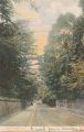
Woolstone Bros. Robin Hood Lane (The Milton "Artlette" Series) (London, [s.d.]). Hand-tinted picture postcard. 139 x 89 mm.. Postcard from private collection.

