
Robin Hood Inn (Monmouth)
From International Robin Hood Bibliography
| Locality | |
|---|---|
| Coordinate | 51.809439, -2.719214 |
| Adm. div. | Monmouthshire |
| Vicinity | 124-126 Monnow Street, Monmouth |
| Type | Public house |
| Interest | Robin Hood name |
| Status | Extant |
| First Record | |
The Robin Hood Inn, Monmouth.

By Henrik Thiil Nielsen, 2013-07-08. Revised by Henrik Thiil Nielsen, 2022-05-27.
The Robin Hood Inn (Welsh: Gwesty Robin Hood) is a listed 15th century building. It has a beer garden and children's play area.
Gazetteers
- British Listed Buildings
- Royal Commission on the Ancient and Historical Monuments of Wales: Robin Hood Inn, 126 Monnow Street, Monmouth
- UK Pub Finder: Robin Hood Inn, Monmouth, Gwent
Sources
Postcards
Image gallery
Click any image to display it in the lightbox, where you can navigate between images by clicking in the right or left side of the current image.
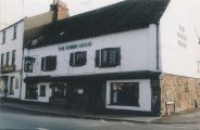
Gwent Federation of Women's Institutes. The Robin Hood, Monmouth ([s.l], [s.d]) / HTN collection.
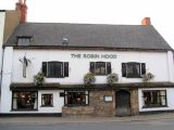
The Robin Hood / philbly.
.jpg)