
Robin Hood Hotel (Blackpool): Difference between revisions
From International Robin Hood Bibliography
m (Text replacement - "|service=leaflet}}" to "|service=leaflet|enablefullscreen=yes}}") |
m (→Maps) |
||
| Line 15: | Line 15: | ||
* [https://maps.nls.uk/view/126516413#zoom=4&lat=4154&lon=11030&layers=BT 25" O.S. map ''Lancashire'' L.4 (1947; rev. 1938)] | * [https://maps.nls.uk/view/126516413#zoom=4&lat=4154&lon=11030&layers=BT 25" O.S. map ''Lancashire'' L.4 (1947; rev. 1938)] | ||
* [https://maps.nls.uk/geo/explore/#zoom=17&lat=53.8468&lon=-3.0522&layers=168&b=5 25" O.S. map ''Lancashire'' L.4 (1912; rev. 1909)] (georeferenced) | * [https://maps.nls.uk/geo/explore/#zoom=17&lat=53.8468&lon=-3.0522&layers=168&b=5 25" O.S. map ''Lancashire'' L.4 (1912; rev. 1909)] (georeferenced) | ||
* [https://maps.nls.uk/view/102343913#zoom=4&lat=5928&lon=12288&layers=BT 6" O.S. map '' (1847; surveyed 1844)] | * [https://maps.nls.uk/view/102343913#zoom=4&lat=5928&lon=12288&layers=BT 6" O.S. map ''Sheet L'' (1847; surveyed 1844)] | ||
* [https://maps.nls.uk/view/101101457#zoom=4&lat=3750&lon=6071&layers=BT 6" O.S. map ''Lancashire'' L.NE (1895; surveyed 1890)] | * [https://maps.nls.uk/view/101101457#zoom=4&lat=3750&lon=6071&layers=BT 6" O.S. map ''Lancashire'' L.NE (1895; surveyed 1890)] | ||
* [https://maps.nls.uk/geo/explore/#zoom=17&lat=53.8469&lon=-3.0530&layers=6&b=5 6" O.S. map ''Lancashire'' L.NE (1914; rev. 1909-10)] (georeferenced) | * [https://maps.nls.uk/geo/explore/#zoom=17&lat=53.8469&lon=-3.0530&layers=6&b=5 6" O.S. map ''Lancashire'' L.NE (1914; rev. 1909-10)] (georeferenced) | ||
Revision as of 12:32, 31 May 2019
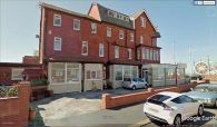
The former Robin Hood Hotel.
[[File:|thumb|right|500px|The former Robin Hood Hotel seen from Cavendish Road.]]
By Henrik Thiil Nielsen, 2013-08-07. Revised by Henrik Thiil Nielsen, 2019-05-31.
The former Robin Hood Hotel on the promenade in Blackpool is now, among other things, the Fossil Tree Hotel.
Gazetteers
- Not included in Dobson, R. B., ed.; Taylor, J., ed. Rymes of Robyn Hood: an Introduction to the English Outlaw (London, 1976), pp. 293-11.
Maps
Maps of the area.
- 25" O.S. map Lancashire L.4 (1893; surveyed 1890)
- 25" O.S. map Lancashire L.4 (1912; rev. 1909)
- 25" O.S. map Lancashire L.4 (1936; rev. 1930)
- 25" O.S. map Lancashire L.4 (1947; rev. 1938)
- 25" O.S. map Lancashire L.4 (1912; rev. 1909) (georeferenced)
- 6" O.S. map Sheet L (1847; surveyed 1844)
- 6" O.S. map Lancashire L.NE (1895; surveyed 1890)
- 6" O.S. map Lancashire L.NE (1914; rev. 1909-10) (georeferenced)
- 6" O.S. map Lancashire L.NE (1914; rev. 1909-10)
- 6" O.S. map Lancashire L.NE (1932-33; rev. 1930-31)
- 6" O.S. map Lancashire L.NE (1946; rev. 1938).
The former Robin Hood Hotel seen from Cavendish Road.
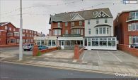
The former Robin Hood Hotel seen from Queen's Parade.
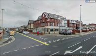
The former Robin Hood Hotel seen from the corner of Queen's Parade and Cavendish Road (same angle as in the next image).


