
Robin Hood Field (Sellack): Difference between revisions
m (Text replacement - "Creative Commons via Geograph" to "Creative Commons, via Geograph") |
m (→Maps) |
||
| Line 23: | Line 23: | ||
* [http://maps.nls.uk/geo/explore/#zoom=16&lat=51.9492&lon=-2.6076&layers=6&b=1 6" O.S. map ''Herefordshire'' XLVI.SE (1905; rev. 1903)] (georeferenced) | * [http://maps.nls.uk/geo/explore/#zoom=16&lat=51.9492&lon=-2.6076&layers=6&b=1 6" O.S. map ''Herefordshire'' XLVI.SE (1905; rev. 1903)] (georeferenced) | ||
* [http://maps.nls.uk/view/101570259#zoom=4&lat=4545&lon=2574&layers=BT O.S. map ''Herefordshire'' XLVI.SE (1953; rev. 1943-48)] | * [http://maps.nls.uk/view/101570259#zoom=4&lat=4545&lon=2574&layers=BT O.S. map ''Herefordshire'' XLVI.SE (1953; rev. 1943-48)] | ||
* [http://maps.nls.uk/geo/explore/#zoom=16&lat=51.9497&lon=-2.6062&layers=175&b=1 1:1 million-1:10K O.S. SO 582280 (1900s)] (georeferenced) | * [http://maps.nls.uk/geo/explore/#zoom=16&lat=51.9497&lon=-2.6062&layers=175&b=1 1:1 million-1:10K O.S. SO 582280 (1900s)] (georeferenced). | ||
{{PnItemAlsoSee}} | {{PnItemAlsoSee}} | ||
Revision as of 10:16, 31 May 2019
[[File:|thumb|right|500px|The brown field beyond the end of the bridge is or used to be known as Robin Hood Field / Google Earth Street View.]]
By Henrik Thiil Nielsen, 2018-02-13. Revised by Henrik Thiil Nielsen, 2019-05-31.
'Robin Hood Field' is or was the name of a close east of the former Gloucester to Hereford line, in Strangford, Sellack. It is recorded in the MS tithe award for Sellack, prepared 1839-40 (see MS sources section below).Template:PnItemQry
Gazetteers
- Not included in Dobson, R. B., ed.; Taylor, J., ed. Rymes of Robyn Hood: an Introduction to the English Outlaw (London, 1976), pp. 293-311.
MS sources
- Tithe award, plot No. 68 (The Genealogist: Piece 14, Sub-Piece 188, Image 010) (subscription required). Date 1840.
- Tithe map (The Genealogist: Piece 14, Sub-Piece 188, Sub-Image 001) (subscription required). Map, dated 1839.
Web sources
Maps
- 25" O.S. map Herefordshre XLVI.11 (1888; surveyed 1887)
- 25" O.S. map Herefordshre XLVI.11 (1904; rev. 1903)
- 25" O.S. map Herefordshre XLVI.11 (1904; rev. 1903) (georeferenced)
- 6" O.S. map Herefordshire XLVI.SE (1887; surveyed 1887)
- 6" O.S. map Herefordshire XLVI.SE (1905; rev. 1903)
- 6" O.S. map Herefordshire XLVI.SE (1905; rev. 1903) (georeferenced)
- O.S. map Herefordshire XLVI.SE (1953; rev. 1943-48)
- 1:1 million-1:10K O.S. SO 582280 (1900s) (georeferenced).
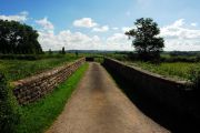
Sidonia bridge over former Gloucester to Hereford line (cutting filled in). second green close beyond far end of bridge is Robin Hood Field / John Winter, 21 Jun. 2014, Creative Commons, via Geograph.
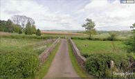
The brown field beyond the end of the bridge is or used to be known as Robin Hood Field / Google Earth Street View.

