
Robin Hood Crossroads (Edwinstowe): Difference between revisions
From International Robin Hood Bibliography
mNo edit summary |
mNo edit summary |
||
| Line 17: | Line 17: | ||
{{ImgGalleryIntro}} | {{ImgGalleryIntro}} | ||
<gallery widths="195px"> | <gallery widths="195px"> | ||
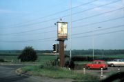
geograph-2267179-by-Helmut-Zozmann.jpg|Robin Hood Crossroads with the sign of the Robin Hood | geograph-2267179-by-Helmut-Zozmann.jpg|Robin Hood Crossroads with the sign of the Robin Hood / [http://www.geograph.org.uk/photo/2267179 Helmut Zozmann, July 1980; Creative Commons via Geograph.] | ||
</gallery> | </gallery> | ||
{{PnItemNav}} | {{PnItemNav}} | ||
Revision as of 12:31, 16 October 2018
Robin Hood Crossroads.

Robin Hood Crossroads with the sign of the Robin Hood (1980) / Helmut Zozmann; Creative Commons via Geograph.
By Henrik Thiil Nielsen, 2013-08-07. Revised by Henrik Thiil Nielsen, 2018-10-16.
Template:PnItemQry
The junction in Edwinstowe where the B6030 and B6034 meet is known as the Robin Hood Crossroads. It is named after the Robin Hood pub located there.[1]
Sources
Notes
Robin Hood Crossroads with the sign of the Robin Hood / Helmut Zozmann, July 1980; Creative Commons via Geograph.