
Robin Hood (Tottington): Difference between revisions
m (Text replacement - "|service=leaflet}}" to "|service=leaflet|enablefullscreen=yes}}") |
m (Text replacement - ", piece" to ", Piece") |
||
| (24 intermediate revisions by the same user not shown) | |||
| Line 1: | Line 1: | ||
__NOTOC__{{ | __NOTOC__{{PlaceNamesItemTop|Lat=53.614654|Lon=-2.340878|AdministrativeDivision=Lancashire|Vicinity=19 Market Street, Tottington, Bury|Type=Public house|Interest=Robin Hood name|Status=Extant|Demonym=|Riding=|GreaterLondon=|Year=1838|Aka=|Century=|Cluster1=Tottington|Cluster2=|Cluster3=|Image=geograph-1796468-by-David-Dixon.jpg|Postcards=|ExtraCat1=|ExtraCat2=|ExtraCat3=|ExtraCat4=|ExtraCat5=|ExtraLink1=|ExtraLink2=|ExtraLink3=|ExtraLink4=|ExtraLink5=|ExtraLinkName1=|ExtraLinkName2=|ExtraLinkName3=|ExtraLinkName4=|ExtraLinkName5=|GeopointPrefix=|GeopointSuffix=|StatusSuffix=|DatePrefix=|DateSuffix=}} | ||
{{#display_map:{{#var:Coords}}~{{#replace:{{PAGENAME}}|'|'}}|width=34% | [[File:{{#var:Image}}|thumb|right|500px|The Robin Hood, Market Street, Tottington / [https://m.geograph.org.uk/photo/1796468 David Dixon, 8 Apr. 2010; Creative Commons, via Geograph.]]] | ||
{{#display_map:{{#var:Coords}}~{{#replace:{{PAGENAME}}|'|'}}|width=34%|enablefullscreen=yes}}<div class="pnMapLegend">The Robin Hood.</div><div class="no-img"> | |||
<p id="byline">By Henrik Thiil Nielsen, 2013-08-07. Revised by {{#realname:{{REVISIONUSER}}}}, {{REVISIONYEAR}}-{{REVISIONMONTH}}-{{REVISIONDAY2}}.</p> | <p id="byline">By Henrik Thiil Nielsen, 2013-08-07. Revised by {{#realname:{{REVISIONUSER}}}}, {{REVISIONYEAR}}-{{REVISIONMONTH}}-{{REVISIONDAY2}}.</p> | ||
< | The Robin Hood at 19 Market Street, Tottington, Bury, was in business by 1838. | ||
It is included in the tithe award for the 'township of Tottington Lower End in the parish of Bury' (1838), with William Hampson as landowner and George Scarnell as occupier. Three plots are listed under the heading of 'Robin Hood': | |||
* plot No. 889: 'Robin Hood Public House[,] Barn[,] Cow house[,] stable Y<sup>d</sup>', occupying a combined area of 26 perches ({{AcresRoodsPerchesToM2|0|0|26}} m<sup>2</sup>) | |||
* plot No. 990: 'Bowling green', with an area of 1 rood and 12 perches ({{AcresRoodsPerchesToM2|0|0|12}} m<sup>2</sup>) | |||
* plot No. 991: 'Way bank', with an area of 1 acre, 2 roods and 22 perches ({{AcresRoodsPerchesToM2|1|2|22}} m<sup>2</sup>) | |||
yielding a total area of 2 acres, 1 rood and 20 perches ({{AcresRoodsPerchesToM2|2|1|20}} m<sup>2</sup>). No state of cultivation is listed for the two first, but the last is listed as 'meadow'.<ref>1838 tithe award for the 'township of Tottington Lower End in the parish of Bury', online at the [https://www.thegenealogist.com Genealogist], Piece 18, sub-piece 308, Image 087, #889-91 (£); accompanying map, online at the [https://www.thegenealogist.com Genealogist], Piece 18, sub-piece 308, Sub-Image 001, #889-91 (£).</ref> | |||
The Robin Hood is named on the early 25" O.S. maps of the area but is indicated, if at all, only by 'P.H.' on the 6" maps (see links below). By 1930 there was a [[Robin Hood Brewery (Tottington)|Robin Hood Brewery]] adjacent to the pub. See further [[Tottington place-name cluster]]. A parking lot now occupies the area formerly taken up by the pub's bowling green. | |||
== MS sources == | |||
* 1838 tithe award for the 'township of Tottington Lower End in the parish of Bury', online at the [https://www.thegenealogist.com Genealogist], Piece 18, sub-piece 308, Image 087, #889-91 (£) | |||
* accompanying map, online at the [https://www.thegenealogist.com Genealogist], Piece 18, sub-piece 308, Sub-Image 001, #889-91 (£). | |||
== Gazetteers == | == Gazetteers == | ||
* Not included in {{:Dobson, Richard Barrie 1976a}}, pp. 293-11. | * Not included in {{:Dobson, Richard Barrie 1976a}}, pp. 293-11. | ||
== Maps == | |||
* [https://maps.nls.uk/view/126520430#zoom=7&lat=3055&lon=1841&layers=BT 25" O.S. map ''Lancashire'' LXXXVII.4 (1893; surveyed 1891)] | |||
* [https://maps.nls.uk/geo/explore/#zoom=18&lat=53.61478&lon=-2.34107&layers=168&b=5 25" O.S. map ''Lancashire'' LXXXIX.1 (1910; rev. 1908)] (georeferenced) | |||
* [https://maps.nls.uk/view/126520433#zoom=7&lat=3235&lon=2304&layers=BT 25" O.S. map ''Lancashire'' LXXXVII.4 (1910; rev. 1908)] | |||
* [https://maps.nls.uk/view/126520436#zoom=7&lat=2991&lon=2301&layers=BT 25" O.S. map ''Lancashire'' LXXXVII.4 (1930; rev. 1927–28)] | |||
* [https://maps.nls.uk/geo/explore/#zoom=17&lat=53.61448&lon=-2.34259&layers=6&b=5 6" O.S. map ''Lancashire'' LXXXVII.NE (1911; rev. 1907–08)] (georeferenced) | |||
* [https://maps.nls.uk/view/102344024#zoom=7&lat=8231&lon=11610&layers=BT 6" O.S. map ''Lancashire'' LXXXVII (1850; surveyed 1844–47)] | |||
* [https://maps.nls.uk/view/101102891#zoom=7&lat=3999&lon=5137&layers=BT 6" O.S. map ''Lancashire'' LXXXVII.NE (1894; surveyed 1889–91)] | |||
* [https://maps.nls.uk/view/101102888#zoom=7&lat=4144&lon=4974&layers=BT 6" O.S. map ''Lancashire'' LXXXVII.NE (1911; rev. 1907–08)] | |||
* [https://maps.nls.uk/view/101102885#zoom=7&lat=4214&lon=4836&layers=BT 6" O.S. map ''Lancashire'' LXXXVII.NE (1931; rev. 1927–28)] | |||
* [https://maps.nls.uk/view/101102882#zoom=7&lat=4109&lon=4712&layers=BT 6" O.S. map ''Lancashire'' LXXXVII.NE (1947; rev. 1938).] | |||
== Background == | |||
* [https://www.facebook.com/robinhoodtotty Facebook: The Robin Hood – Tottington.] | |||
{{PlaceNamesItemAlsoSee}} | |||
== Notes == | |||
<references/> | |||
</div> | </div> | ||
{{ImageGalleryIntroduction}} | |||
<gallery widths="195px"> | |||
geograph-1796468-by-David-Dixon.jpg|The Robin Hood, Market Street, Tottington / [https://m.geograph.org.uk/photo/1796468 David Dixon, 8 Apr. 2010; Creative Commons, via Geograph.] | |||
geograph-5912833-by-JThomas.jpg|The Robin Hood public house, Tottington / [https://m.geograph.org.uk/photo/5912833 J. Thomas, 17 Sep. 2018; Creative Commons, via Geograph.] | |||
geograph-5912870-by-JThomas.jpg|Sign of the Robin Hood public house, Tottington / [https://m.geograph.org.uk/photo/5912870 J. Thomas, 17 Sep. 2018; Creative Commons, via Geograph.] | |||
</gallery> | |||
{{ | {{PlaceNamesItemNavigation}} | ||
Latest revision as of 19:16, 22 April 2022
| Locality | |
|---|---|
| Coordinate | 53.614654, -2.340878 |
| Adm. div. | Lancashire |
| Vicinity | 19 Market Street, Tottington, Bury |
| Type | Public house |
| Interest | Robin Hood name |
| Status | Extant |
| First Record | 1838 |

By Henrik Thiil Nielsen, 2013-08-07. Revised by Henrik Thiil Nielsen, 2022-04-22.
The Robin Hood at 19 Market Street, Tottington, Bury, was in business by 1838.
It is included in the tithe award for the 'township of Tottington Lower End in the parish of Bury' (1838), with William Hampson as landowner and George Scarnell as occupier. Three plots are listed under the heading of 'Robin Hood':
- plot No. 889: 'Robin Hood Public House[,] Barn[,] Cow house[,] stable Yd', occupying a combined area of 26 perches (657.61 m2)
- plot No. 990: 'Bowling green', with an area of 1 rood and 12 perches (303.51 m2)
- plot No. 991: 'Way bank', with an area of 1 acre, 2 roods and 22 perches (6626.73 m2)
yielding a total area of 2 acres, 1 rood and 20 perches (9611.28 m2). No state of cultivation is listed for the two first, but the last is listed as 'meadow'.[1]
The Robin Hood is named on the early 25" O.S. maps of the area but is indicated, if at all, only by 'P.H.' on the 6" maps (see links below). By 1930 there was a Robin Hood Brewery adjacent to the pub. See further Tottington place-name cluster. A parking lot now occupies the area formerly taken up by the pub's bowling green.
MS sources
- 1838 tithe award for the 'township of Tottington Lower End in the parish of Bury', online at the Genealogist, Piece 18, sub-piece 308, Image 087, #889-91 (£)
- accompanying map, online at the Genealogist, Piece 18, sub-piece 308, Sub-Image 001, #889-91 (£).
Gazetteers
- Not included in Dobson, R. B., ed.; Taylor, J., ed. Rymes of Robyn Hood: an Introduction to the English Outlaw (London, 1976), pp. 293-11.
Maps
- 25" O.S. map Lancashire LXXXVII.4 (1893; surveyed 1891)
- 25" O.S. map Lancashire LXXXIX.1 (1910; rev. 1908) (georeferenced)
- 25" O.S. map Lancashire LXXXVII.4 (1910; rev. 1908)
- 25" O.S. map Lancashire LXXXVII.4 (1930; rev. 1927–28)
- 6" O.S. map Lancashire LXXXVII.NE (1911; rev. 1907–08) (georeferenced)
- 6" O.S. map Lancashire LXXXVII (1850; surveyed 1844–47)
- 6" O.S. map Lancashire LXXXVII.NE (1894; surveyed 1889–91)
- 6" O.S. map Lancashire LXXXVII.NE (1911; rev. 1907–08)
- 6" O.S. map Lancashire LXXXVII.NE (1931; rev. 1927–28)
- 6" O.S. map Lancashire LXXXVII.NE (1947; rev. 1938).
Background
Also see
Notes
- ↑ 1838 tithe award for the 'township of Tottington Lower End in the parish of Bury', online at the Genealogist, Piece 18, sub-piece 308, Image 087, #889-91 (£); accompanying map, online at the Genealogist, Piece 18, sub-piece 308, Sub-Image 001, #889-91 (£).
Image gallery
Click any image to display it in the lightbox, where you can navigate between images by clicking in the right or left side of the current image.
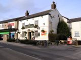
The Robin Hood, Market Street, Tottington / David Dixon, 8 Apr. 2010; Creative Commons, via Geograph.
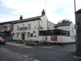
The Robin Hood public house, Tottington / J. Thomas, 17 Sep. 2018; Creative Commons, via Geograph.
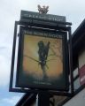
Sign of the Robin Hood public house, Tottington / J. Thomas, 17 Sep. 2018; Creative Commons, via Geograph.

