
Robin Hood (Knaphill, Woking): Difference between revisions
From International Robin Hood Bibliography
m (Text replacement - "Creative Commons via Geograph" to "Creative Commons, via Geograph") |
rh>Henryfunk mNo edit summary |
||
| Line 30: | Line 30: | ||
== Notes == | == Notes == | ||
<references/> | <references/> | ||
</div> | |||
< | <div id="gallery"> | ||
{{ImgGalleryIntro}} | {{ImgGalleryIntro}} | ||
<gallery widths="195px"> | <gallery widths="195px"> | ||
| Line 38: | Line 39: | ||
Cresswell, F W 19xxa-r.jpg|{{:Cresswell, F W 19xxa}} / Private collection. | Cresswell, F W 19xxa-r.jpg|{{:Cresswell, F W 19xxa}} / Private collection. | ||
</gallery> | </gallery> | ||
</div> | |||
{{PnItemNav}} | {{PnItemNav}} | ||
Revision as of 11:30, 15 May 2020
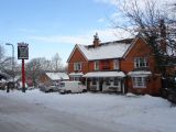
The Robin Hood.
[[File:|thumb|right|500px|The Robin Hood, Knaphill / Alan Hunt, 9 Jan. 2010, Creative Commons, via Geograph.]]
By Henrik Thiil Nielsen, 2013-08-07. Revised by 18.191.174.168, 2020-05-15.
The Robin Hood is located at 88 Robin Hood Road, Knaphill, Woking. The earliest reference I have found so far is a 6" O.S. map of the area published in 1873, based on surveying carried out 1870-71 (see Maps section below). Information on publicans for the years 1913-18 can be found at UK Pub History.[1]Template:PnItemQry
Gazetteers
- Not included in Dobson, R. B., ed.; Taylor, J., ed. Rymes of Robyn Hood: an Introduction to the English Outlaw (London, 1976), pp. 293-311.
Sources
Maps
- 25" O.S. map Surrey XVI.11 (1916; rev. 1913) (georeferenced)
- 25" O.S. map Surrey XVI.11 (1916; rev. 1913)
- 25" O.S. map Surrey XVI.11 (1936; rev. 1934)
- 25" O.S. map Surrey XVI.11 (1916; rev. 1913)
- 6" O.S. map Surrey XVI (1873; surveyed 1870-71)
- 6" O.S. map Surrey XVI.SE (1897; rev. 1894-95)
- 6" O.S. map Surrey XVI.SE (1897; rev. 1894-95) (georeferenced)
- 6" O.S. map Surrey XVI.SE (1920; rev. 1913)
- 6" O.S. map Surrey XVI.SE (1937; rev. 1934-35)
- 6" O.S. map Surrey XVI.SE (c. 1944; rev. 1938)
- 6" O.S. map Surrey XVI.SE (c. 1946; rev. 1938).
Background
Notes
The Robin Hood, Knaphill / Alan Hunt, 9 Jan. 2010, Creative Commons, via Geograph.
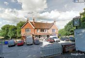
The Robin Hood / Google Earth Street View.


