
Robin Hood (Durley Street): Difference between revisions
From International Robin Hood Bibliography
m (Text replacement - "|service=leaflet}}" to "|service=leaflet|enablefullscreen=yes}}") |
m (Text replacement - "Creative Commons via Geograph" to "Creative Commons, via Geograph") |
||
| Line 30: | Line 30: | ||
<gallery widths="195px"> | <gallery widths="195px"> | ||
robin-hood-durley-street-google-earth-street-view.jpg|The Robin Hood in Durley Street / Google Maps Street View. | robin-hood-durley-street-google-earth-street-view.jpg|The Robin Hood in Durley Street / Google Maps Street View. | ||
geograph-057205-by-Peter-Facey.jpg|On Durley Street in Durley Street. The Robin Hood Inn is on a crossroads just beyond the brown car in / [http://www.geograph.org.uk/photo/57205 Peter Facey, 24 Sep. 2015, Creative Commons via Geograph.] | geograph-057205-by-Peter-Facey.jpg|On Durley Street in Durley Street. The Robin Hood Inn is on a crossroads just beyond the brown car in / [http://www.geograph.org.uk/photo/57205 Peter Facey, 24 Sep. 2015, Creative Commons, via Geograph.] | ||
</gallery> | </gallery> | ||
{{PnItemNav}} | {{PnItemNav}} | ||
Revision as of 11:23, 30 May 2019
The Robin Hood.

By Henrik Thiil Nielsen, 2014-09-25. Revised by Henrik Thiil Nielsen, 2019-05-30.
The Robin Hood on the road named 'Durley Street' in the village named 'Durley Street' was in existence by 1871, when it was included, as "Robin Hood & Little John", on a 6" O.S. map of the area. Two later 6" O.S. maps omit the pub's name, indicating only "Inn". UK Pub History lists publican information for the year 1927 only.[1]Template:PnItemQry
Gazetteers
- Not included in Dobson, R. B., ed.; Taylor, J., ed. Rymes of Robyn Hood: an Introduction to the English Outlaw (London, 1976), pp. 293-311.
Sources
Maps
- 6" O.S. map Hampshire & Isle of Wight LVIII (1871; surveyed 1863)
- 6" O.S. map Hampshire & Isle of Wight LVIII.SE (1897; rev. 1895) (indicates only 'Inn')
- 6" O.S. map Hampshire & Isle of Wight LVIII.SE (1897; rev. 1895) (georeferenced; indicates only 'Inn')
- 6" O.S. map Hampshire & Isle of Wight LVIII.SE (1910; rev. 1908) (indicates only 'Inn').
Background
- Facebook: Robin Hood Pub, Durley
- [www.therobinhooddurley.co.uk The Robin Hood] (the pub's website)
- Wikipedia: Durley Street.
Notes
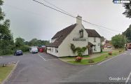
The Robin Hood in Durley Street / Google Maps Street View.
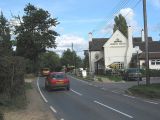
On Durley Street in Durley Street. The Robin Hood Inn is on a crossroads just beyond the brown car in / Peter Facey, 24 Sep. 2015, Creative Commons, via Geograph.
