
Robin Hood (Borrowdale): Difference between revisions
From International Robin Hood Bibliography
mNo edit summary |
mNo edit summary |
||
| Line 70: | Line 70: | ||
{{#set:century={{#var:CenturyOrdinal}}}} | {{#set:century={{#var:CenturyOrdinal}}}} | ||
{{#set:Utitle={{#replace:{{uc:{{PAGENAME}}}}|'|'}}}} | {{#set:Utitle={{#replace:{{uc:{{PAGENAME}}}}|'|'}}}} | ||
{{#set:Pnimage= | {{#set:Pnimage=cairn-on-robin-hood-michael-graham-geograph.jpg}} | ||
Revision as of 12:16, 28 August 2017
| Locality | |
|---|---|
| Coordinates | 54.4474, -2.2786 |
| Adm. div. | Westmorland |
| Vicinity | c. 4.6 km E of Sadgill and c. 800 m E of Borrowdale |
| Type | Natural feature |
| Interest | Robin Hood name |
| Status | Extant |
| First Record | 1859 |
The hill named 'Robin Hood'.

Cairn on the west top of Robin Hood / Michael Graham, 10 Feb. 2008, Geograph, Creative Commons.
By Henrik Thiil Nielsen, 2017-08-28. Revised by Henrik Thiil Nielsen, 2017-08-28.
_TEXT
Gazetteers
- Dobson, R. B., ed.; Taylor, J., ed. Rymes of Robyn Hood: an Introduction to the English Outlaw (London, 1976), p. 305, s.n. Robin Hood.
Sources
- Smith, A.H. The Place-Names of Westmorland (English Place-Name Society, vols. XLII, XLIII) (Cambridge, 1967), pt. II, p. 176; pt. I, p. lxvi for expansion of abbreviated source references.
Maps
Background
Brief mention
Notes
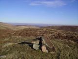
Cairn on the west top of Robin Hood / Michael Graham, 10 Feb. 2008, Geograph, Creative Commons.
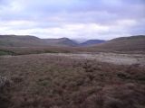
Robin Hood and High House Bank on the left. looking down Borrowdale from Borrowdale Moss / Michael Graham, 4 Jan. 2007, Geograph, Creative Commons.

"th" can not be assigned to a declared number type with value 19.