
Robin Hood (Birstall): Difference between revisions
From International Robin Hood Bibliography
m (Text replacement - "|service=leaflet}}" to "|service=leaflet|enablefullscreen=yes}}") |
m (Text replacement - "Creative Commons via Geograph" to "Creative Commons, via Geograph") |
||
| Line 1: | Line 1: | ||
__NOTOC__{{PnItemTop|Lat=53.730659|Lon=-1.660328|AdmDiv=Yorkshire|Vicinity=NW side of Huddersfield Road, Birstall|Type=Public house|Interest=Robin Hood name|Status=Defunct|Demonym=English|Riding=West|GreaterLondon=|Year=1891|Aka=|Century=|Cluster1=|Cluster2=|Cluster3=|Image=geograph-1124406-by-Betty-Longbottom.jpg|Postcards=|ExtraCat1=|ExtraCat2=|ExtraCat3=|ExtraCat4=|ExtraCat5=|ExtraLink1=|ExtraLink2=|ExtraLink3=|ExtraLink4=|ExtraLink5=|ExtraLinkName1=|ExtraLinkName2=|ExtraLinkName3=|ExtraLinkName4=|ExtraLinkName5=|GeopointPrefix=|GeopointSuffix=|StatusSuffix=|DatePrefix=|DateSuffix=}} | __NOTOC__{{PnItemTop|Lat=53.730659|Lon=-1.660328|AdmDiv=Yorkshire|Vicinity=NW side of Huddersfield Road, Birstall|Type=Public house|Interest=Robin Hood name|Status=Defunct|Demonym=English|Riding=West|GreaterLondon=|Year=1891|Aka=|Century=|Cluster1=|Cluster2=|Cluster3=|Image=geograph-1124406-by-Betty-Longbottom.jpg|Postcards=|ExtraCat1=|ExtraCat2=|ExtraCat3=|ExtraCat4=|ExtraCat5=|ExtraLink1=|ExtraLink2=|ExtraLink3=|ExtraLink4=|ExtraLink5=|ExtraLinkName1=|ExtraLinkName2=|ExtraLinkName3=|ExtraLinkName4=|ExtraLinkName5=|GeopointPrefix=|GeopointSuffix=|StatusSuffix=|DatePrefix=|DateSuffix=}} | ||
{{#display_map:{{#var:Coords}}~{{#replace:{{PAGENAME}}|'|'}}|width=34%|service=leaflet|enablefullscreen=yes}}<div class="pnMapLegend">Union Street</div> | {{#display_map:{{#var:Coords}}~{{#replace:{{PAGENAME}}|'|'}}|width=34%|service=leaflet|enablefullscreen=yes}}<div class="pnMapLegend">Union Street</div> | ||
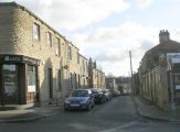
[[File:{{#var:Pnimage}}|thumb|right|500px|Union Street - Smithies Lane / [https://www.geograph.org.uk/photo/1124406 Betty Longbottom, 17 Jan. 2009, Creative Commons via Geograph.]]] | [[File:{{#var:Pnimage}}|thumb|right|500px|Union Street - Smithies Lane / [https://www.geograph.org.uk/photo/1124406 Betty Longbottom, 17 Jan. 2009, Creative Commons, via Geograph.]]] | ||
<p id="byline">By Henrik Thiil Nielsen, 2018-10-25. Revised by {{#realname:{{REVISIONUSER}}}}, {{REVISIONYEAR}}-{{REVISIONMONTH}}-{{REVISIONDAY2}}.</p><div class="no-img"> | <p id="byline">By Henrik Thiil Nielsen, 2018-10-25. Revised by {{#realname:{{REVISIONUSER}}}}, {{REVISIONYEAR}}-{{REVISIONMONTH}}-{{REVISIONDAY2}}.</p><div class="no-img"> | ||
The long gone Robin Hood on Union Street in Birstall probably existed by 1871. According to census entries there was a beer house there at that time, but it is only referred to as the Robin Hood in the 1891 census. Information on publicans etc. for the years 1871-91 can be found at UK Pub History.<ref>[https://pubhistory.co.uk//Yorkshire/Birstall/RobinHood.shtml UK Pub History: Robin Hood, Union street, Birstall, West Yorkshire WF17.]</ref>{{PnItemQry}} | The long gone Robin Hood on Union Street in Birstall probably existed by 1871. According to census entries there was a beer house there at that time, but it is only referred to as the Robin Hood in the 1891 census. Information on publicans etc. for the years 1871-91 can be found at UK Pub History.<ref>[https://pubhistory.co.uk//Yorkshire/Birstall/RobinHood.shtml UK Pub History: Robin Hood, Union street, Birstall, West Yorkshire WF17.]</ref>{{PnItemQry}} | ||
| Line 33: | Line 33: | ||
{{ImgGalleryIntro}} | {{ImgGalleryIntro}} | ||
<gallery widths="195px"> | <gallery widths="195px"> | ||
geograph-1124406-by-Betty-Longbottom.jpg|Union Street - Smithies Lane / [https://www.geograph.org.uk/photo/1124406 Betty Longbottom, 17 jan. 2009, Creative Commons via Geograph.] | geograph-1124406-by-Betty-Longbottom.jpg|Union Street - Smithies Lane / [https://www.geograph.org.uk/photo/1124406 Betty Longbottom, 17 jan. 2009, Creative Commons, via Geograph.] | ||
robin-hood-birstall-google-earth-street-view.jpg|Union Street / Google Earth Street View. | robin-hood-birstall-google-earth-street-view.jpg|Union Street / Google Earth Street View. | ||
</gallery> | </gallery> | ||
Revision as of 11:23, 30 May 2019
Union Street
[[File:|thumb|right|500px|Union Street - Smithies Lane / Betty Longbottom, 17 Jan. 2009, Creative Commons, via Geograph.]]
By Henrik Thiil Nielsen, 2018-10-25. Revised by Henrik Thiil Nielsen, 2019-05-30.
The long gone Robin Hood on Union Street in Birstall probably existed by 1871. According to census entries there was a beer house there at that time, but it is only referred to as the Robin Hood in the 1891 census. Information on publicans etc. for the years 1871-91 can be found at UK Pub History.[1]Template:PnItemQry
Gazetteers
- Not included in Dobson, R. B., ed.; Taylor, J., ed. Rymes of Robyn Hood: an Introduction to the English Outlaw (London, 1976), pp. 293-11.
Sources
Maps
- 25" O.S. map Yorkshire CCXXXII.6 (1894; surveyed 1888-92)
- 25" O.S. map Yorkshire CCXXXII.6 (1908; rev. 1905) (georeferenced)
- 25" O.S. map Yorkshire CCXXXII.6 (1908; rev. 1905)
- 25" O.S. map Yorkshire CCXXXII.6 (1922; rev. 1915)
- 25" O.S. map Yorkshire CCXXXII.6 (1942; rev. 1938)
- 6" O.S. map Yorkshire 232 (1854; surveyed 1847-51)
- 6" O.S. map Yorkshire CCXXXII.NW (1894; surveyed 1888-92)
- 6" O.S. map Yorkshire CCXXXII.NW (1908; rev. 1905) (georeferenced)
- 6" O.S. map Yorkshire CCXXXII.NW (1908; rev. 1905)
- 6" O.S. map Yorkshire CCXXXII.NW (1944; rev. 1938)
- 6" O.S. map Yorkshire CCXXXII.NW (1950; rev. 1948).
Notes
Union Street - Smithies Lane / Betty Longbottom, 17 jan. 2009, Creative Commons, via Geograph.
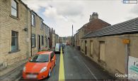
Union Street / Google Earth Street View.

