
Cumberland place-names: Difference between revisions
mNo edit summary |
mNo edit summary |
||
| Line 1: | Line 1: | ||
{{ | {{#vardefine:Lat|54.684932}}{{#vardefine:Lon|-3.201193}}{{#vardefine:County|Cumberland}}{{#vardefine:Riding|NONE}}{{#vardefine:Century|21}}{{#vardefine:CenturyOrdinal|{{#ifeq:{{#var:Century}}|21|21st|{{#var:Century}}th}}}}{{#vardefine:PnClusterRef|Bassenthwaite}}__NOTOC__ | ||
<p id="byline">By Henrik Thiil Nielsen, 2017- | {{Infobox | ||
|header1=Locality | |||
|label2=Coordinates | |||
|data2=[[Geopoint::{{#var:Lat}},{{#var:Lon}}]] | |||
|label3=Adm. div. | |||
|data3=[[pnadmdiv::{{#var:County}}]] | |||
|label4=Vicinity | |||
|data4=[[pnvicinity::''c.'' 500 m NNW of Bassenthwaite]] | |||
|label5=Type | |||
|data5=[[pntype::Area]] | |||
|label6=Interest | |||
|data6=[[pninterest::Robin Hood name]] | |||
|label7=Status | |||
|data7=[[pnstatus::Extant]] | |||
|label8=First Record | |||
|data8=''c.'' [[pnfirstrecord::2015]] | |||
|label9=A.k.a. | |||
|data9=Robin Hood Park; Robin Hood Caravan Park | |||
}} | |||
{{#display_map:{{#var:Lat}},{{#var:Lon}}|width=34%}}<div class="pnMapLegend">Robin Hood.</div> | |||
[[File:robin-hood-holiday-park-google-earth-street-view-2.jpg|thumb|right|500px|Robin Hood Holiday Park / Google Earth Street View.]] | |||
<p id="byline">By Henrik Thiil Nielsen, 2017-08-29. Revised by {{#realname:{{REVISIONUSER}}}}, {{REVISIONYEAR}}-{{REVISIONMONTH}}-{{REVISIONDAY2}}.</p><div class="no-img"> | |||
Robin Hood Holiday Park immediately NW of [[Robin Hood (Bassenthwaite)]], ''c.'' 2 km NE of Bassenthwaite Lake and ''c.'' 0.6 km NNW of Bassenthwaite village, is a cluster of recently constructed, individually owned holiday lodges.<ref>See [http://www.robinhoodpark.co.uk/ Robin Hood Holiday Park company website.]</ref> The area was previously known as 'Robin Hood Caravan Park'.<ref>[http://www.lakedistrictdirectory.co.uk/robin-hood-carvan-park-i683.html Lake District Directory: Robin Hood Carvan Park.]</ref> | |||
<!--{{#ask:[[Category:Records (_PLACE-NAME)]]| format=embedded|embedformat=h4| columns=1|limit=1000|sort=Utitle}}--> | |||
<!--{{#ask:[[Category:Allusions (_PLACE-NAME)]]| format=embedded|embedformat=h4| columns=1|limit=1000|sort=Utitle}}--> | |||
=== Gazetteers === | |||
== | * Not included in {{:Dobson, Richard Barrie 1976a}}, pp. 293-311. | ||
* {{:Dobson, Richard Barrie 1976a}}, | <!--=== Sources === | ||
* | * --> | ||
=== Maps === | |||
[[Robin Hood (Bassenthwaite)]] vicinity labelled and indicated. | |||
* [http://maps.nls.uk/view/121143467#zoom=5&lat=7409&lon=13841&layers=BT 25" O.S. map ''Cumberland'' XLVI.16 (1900; rev. 1898)] | |||
* [http://maps.nls.uk/view/121143470#zoom=5&lat=7358&lon=14216&layers=BT 25" O.S. map ''Cumberland'' XLVI.16 (1925; rev. 1923)] | |||
* [http://maps.nls.uk/view/102340824#zoom=6&lat=2180&lon=14604&layers=BT 6" O.S. map ''Cumberland'' XLVI (1867; surveyed 1864-65)] | |||
* [http://maps.nls.uk/view/101091685#zoom=5&lat=2716&lon=7526&layers=BT 6" O.S. map ''Cumberland'' XLVI.SE (1900; rev. 1898)] | |||
* [http://maps.nls.uk/geo/explore/#zoom=17&lat=54.6854&lon=-3.2002&layers=171&b=1 6" O.S. map ''Cumberland'' XLVI.SE (1900; rev. 1898)] (georeferenced) | |||
* [http://maps.nls.uk/view/101091682#zoom=5&lat=2945&lon=7627&layers=BT 6" O.S. map ''Cumberland'' XLVI.SE (19230; rev. 1926)] | |||
<!--=== Postcards === | |||
* --> | |||
<!--=== Studies and criticism === | |||
* --> | |||
=== Background === | === Background === | ||
* [http://www. | * [http://www.robinhoodpark.co.uk/ Robin Hood Holiday Park website] | ||
* [https://en.wikipedia.org/wiki/ | * [https://en.wikipedia.org/wiki/Bassenthwaite Wikipedia: Bassenthwaite.] | ||
<!--=== Brief mention === | |||
* --> | |||
=== Also see === | |||
* [[Robin Hood (Bassenthwaite)]] | |||
* [[{{#var:PnClusterRef}} place-name cluster]]. | |||
=== Notes === | === Notes === | ||
| Line 26: | Line 59: | ||
</div> | </div> | ||
{{ImgGalleryIntro}} | |||
<gallery widths="195px"> | |||
File:robin-hood-holiday-park-google-earth-street-view-2.jpg|Robin Hood Holiday Park / Google Earth Street View.] | |||
File:robin-hood-holiday-park-google-earth-street-view-1.jpg|Robin Hood Holiday Park. Someone liked the colour of absinthe! / Google Earth Street View.] | |||
File:robin-hood-holiday-park-google-earth-street-view-3.jpg|Robin Hood Holiday Park / Google Earth Street View.] | |||
File:robin-hood-holiday-park-website-1.jpg|View from the holiday park / [http://www.robinhoodpark.co.uk/gallery/collection.php?collection_id=13 Robin Hood Holiday Park] | |||
File:robin-hood-holiday-park-website-2.jpg|View from cottage at the holiday park / [http://www.robinhoodpark.co.uk/gallery/collection.php?collection_id=13 Robin Hood Holiday Park] | |||
File:robin-hood-holiday-park-website-3.jpg|View from cottage at the holiday park / [http://www.robinhoodpark.co.uk/gallery/collection.php?collection_id=13 Robin Hood Holiday Park] | |||
File:robin-hood-holiday-park-website-4.jpg|Cottage at the holiday park / [http://www.robinhoodpark.co.uk/gallery/collection.php?collection_id=13 Robin Hood Holiday Park] | |||
File:robin-hood-holiday-park-website-5.jpg|View from the holiday park / [http://www.robinhoodpark.co.uk/gallery/collection.php?collection_id=13 Robin Hood Holiday Park] | |||
</gallery> | |||
<div id="dplcatlinks" class="subcategory"><div id="dplcatarea"> | <div id="dplcatlinks" class="subcategory"><div id="dplcatarea"> | ||
{{#ask: [[Category:English | {{#ifeq: {{#var:Riding}}|NONE||<p>{{#ask: [[Category:{{#var:Riding}} Riding of Yorkshire place-names]][[Utitle::<<{{#replace:{{uc:{{PAGENAME}}}}|'|'}}]]|order=descending|searchlabel=|format=template|introtemplate=BeforeNav|template=Nav|outrotemplate=Previous|link=none|limit=1|sort=Utitle}}[[{{#var:Riding}} Riding of Yorkshire place-names]]{{#ask: [[Category:{{#var:Riding}} Riding of Yorkshire place-names]][[Utitle::>>{{#replace:{{uc:{{PAGENAME}}}}|'|'}}]]|order=ascending|searchlabel=|format=template|introtemplate=BeforeNav|template=Nav|outrotemplate=Next|link=none|limit=1|sort=Utitle}}}} | ||
[[Category:English | |||
{{#ask: [[Category:English place-names]] | |||
[[Category:{{#var:County}} place-names]][[Utitle::<<{{#replace:{{uc:{{PAGENAME}}}}|'|'}}]]|order=descending|searchlabel=|format=template|introtemplate=BeforeNav|template=Nav|outrotemplate=Previous|link=none|limit=1|sort=Utitle}}[[{{#var:County}} place-names]]{{#ask: [[Category:English place-names]] | |||
[[Category:{{#var:County}} place-names]][[Utitle::>>{{#replace:{{uc:{{PAGENAME}}}}|'|'}}]]|order=ascending|searchlabel=|format=template|introtemplate=BeforeNav|template=Nav|outrotemplate=Next|link=none|limit=1|sort=Utitle}} | |||
{{#ask: [[Category:English place-names]][[Utitle::<<{{#replace:{{uc:{{PAGENAME}}}}|'|'}}]]|order=descending|searchlabel=|format=template|introtemplate=BeforeNav|template=Nav|outrotemplate=Previous|link=none|limit=1|sort=Utitle}}[[Place-names]]{{#ask: [[Category:English place-names]][[Utitle::>>{{#replace:{{uc:{{PAGENAME}}}}|'|'}}]]|order=ascending|searchlabel=|format=template|introtemplate=BeforeNav|template=Nav|outrotemplate=Next|link=none|limit=1|sort=Utitle}}</div></div> | |||
[[Category:Place-names-topics]] | [[Category:Place-names-topics]] | ||
[[Category:English place-names]] | |||
[[Category:{{#var:County}} place-names]] | |||
[[Category:{{#var:PnClusterRef}} place-name cluster]] | |||
[[Category:{{#var:CenturyOrdinal}} century]] | |||
{{#set:century={{#var:CenturyOrdinal}}}} | |||
{{#set:Pnaka=Robin Hood Park; Robin Hood Caravan Park|+sep=;}} | |||
{{#set:Pnimage=robin-hood-holiday-park-google-earth-street-view-2.jpg}} | |||
{{#set:Utitle={{#replace:{{uc:{{PAGENAME}}}}|'|'}}}} | {{#set:Utitle={{#replace:{{uc:{{PAGENAME}}}}|'|'}}}} | ||
Revision as of 03:10, 11 September 2017
| Locality | |
|---|---|
| Coordinates | 54.684932, -3.201193 |
| Adm. div. | Cumberland |
| Vicinity | c. 500 m NNW of Bassenthwaite |
| Type | Area |
| Interest | Robin Hood name |
| Status | Extant |
| First Record | c. 2015 |
| A.k.a. | Robin Hood Park; Robin Hood Caravan Park |

By Henrik Thiil Nielsen, 2017-08-29. Revised by Henrik Thiil Nielsen, 2017-09-11.
Robin Hood Holiday Park immediately NW of Robin Hood (Bassenthwaite), c. 2 km NE of Bassenthwaite Lake and c. 0.6 km NNW of Bassenthwaite village, is a cluster of recently constructed, individually owned holiday lodges.[1] The area was previously known as 'Robin Hood Caravan Park'.[2]
Gazetteers
- Not included in Dobson, R. B., ed.; Taylor, J., ed. Rymes of Robyn Hood: an Introduction to the English Outlaw (London, 1976), pp. 293-311.
Maps
Robin Hood (Bassenthwaite) vicinity labelled and indicated.
- 25" O.S. map Cumberland XLVI.16 (1900; rev. 1898)
- 25" O.S. map Cumberland XLVI.16 (1925; rev. 1923)
- 6" O.S. map Cumberland XLVI (1867; surveyed 1864-65)
- 6" O.S. map Cumberland XLVI.SE (1900; rev. 1898)
- 6" O.S. map Cumberland XLVI.SE (1900; rev. 1898) (georeferenced)
- 6" O.S. map Cumberland XLVI.SE (19230; rev. 1926)
Background
Also see
Notes
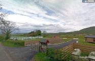
Robin Hood Holiday Park / Google Earth Street View.]
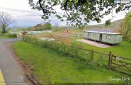
Robin Hood Holiday Park. Someone liked the colour of absinthe! / Google Earth Street View.]
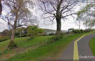
Robin Hood Holiday Park / Google Earth Street View.]
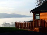
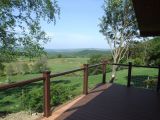
View from the holiday park / Robin Hood Holiday Park
View from cottage at the holiday park / Robin Hood Holiday Park
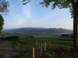
View from cottage at the holiday park / Robin Hood Holiday Park
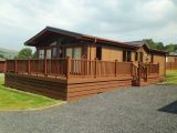
Cottage at the holiday park / Robin Hood Holiday Park
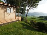
View from the holiday park / Robin Hood Holiday Park


"st" can not be assigned to a declared number type with value 21.