Stanton Fitzwarren (Swindon): Difference between revisions
From International Robin Hood Bibliography
m (Text replacement - "=== Allusions ===" to "== Allusions ==") |
m (Text replacement - "embedformat=h4" to "embedformat=h3") |
||
| Line 24: | Line 24: | ||
<!-- | <!-- | ||
== Allusions == | == Allusions == | ||
{{#ask:[[Category:Allusions (Stanton FItzwarren, Fulk Fitz-Warin)]]| format=embedded|embedformat= | {{#ask:[[Category:Allusions (Stanton FItzwarren, Fulk Fitz-Warin)]]| format=embedded|embedformat=h3|columns=1|limit=1000|sort=Utitle}}--> | ||
== Sources == | == Sources == | ||
* {{:Gover, John Eric Bruce 1939a}}, p. 30. | * {{:Gover, John Eric Bruce 1939a}}, p. 30. | ||
Revision as of 15:47, 12 July 2018
| Locality | |
|---|---|
| Coordinates | 51.611417, -1.744836 |
| Adm. div. | Wiltshire |
| Vicinity | c. 2 km NE of Swindon |
| Type | Settlement |
| Interest | Fulk Fitz-Warin name |
| Status | Extant |
| First Record | 1394 |
Stanton Fitzwarren.

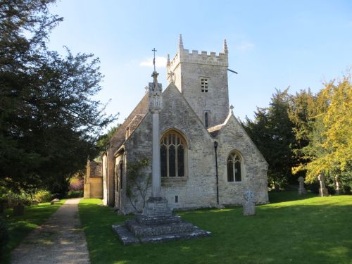
The Church of St Leonard at Stanton Fitzwarren / Peter Wood via Geograph. Licensed for reuse under Creative Commons Licence.
By Henrik Thiil Nielsen, 2017-01-05. Revised by Henrik Thiil Nielsen, 2018-07-12.
Stanton Fitzwarren, a bit northeast of Swindon, is first recorded in Domesday Book (1086), where it occurs as 'Stantone'. The present form of the name is first recorded in 1394 ('Staunton Fitz Waryn'). The manor belonged to Fulk Fitz-Warin in 1196[1]
Sources
Maps
- 6" O.S. map Berkshire XII (1883; surveyed 1876-78)
- 6" O.S. map Berkshire XII.NW (1900; surveyed 1897)
- 6" O.S. map Berkshire XII.NW (1913; surveyed 1910)
- 6" O.S. map Berkshire XII.NW (1925; surveyed 1910).
Background
Notes
