Sherwood Rise (Eastwood): Difference between revisions
From International Robin Hood Bibliography
m (Text replacement - "PnItemAlsoSee" to "PlaceNamesItemAlsoSee") |
m (Text replacement - "ImgGalleryIntro" to "ImageGalleryIntroduction") |
||
| (One intermediate revision by the same user not shown) | |||
| Line 4: | Line 4: | ||
<p id="byline">By Henrik Thiil Nielsen, 2018-05-26. Revised by {{#realname:{{REVISIONUSER}}}}, {{REVISIONYEAR}}-{{REVISIONMONTH}}-{{REVISIONDAY2}}.</p> | <p id="byline">By Henrik Thiil Nielsen, 2018-05-26. Revised by {{#realname:{{REVISIONUSER}}}}, {{REVISIONYEAR}}-{{REVISIONMONTH}}-{{REVISIONDAY2}}.</p> | ||
Sherwood Rise is a residential side street of Plumptre Way in Eastwood. As it is not included on earlier O.S. maps, it probably dates from the last half of the 20th century. | Sherwood Rise is a residential side street of Plumptre Way in Eastwood. As it is not included on earlier O.S. maps, it probably dates from the last half of the 20th century. | ||
{{ | {{PlaceNamesItemAllusionsAndRecords}} | ||
== Gazetteers == | == Gazetteers == | ||
* Not included in {{:Dobson, Richard Barrie 1976a}}, pp. 293-311. | * Not included in {{:Dobson, Richard Barrie 1976a}}, pp. 293-311. | ||
| Line 29: | Line 29: | ||
<!--<div id="gallery"> | <!--<div id="gallery"> | ||
{{ | {{ImageGalleryIntroduction}} | ||
<gallery widths="195px"> | <gallery widths="195px"> | ||
FOR EACH IMAGE: File:_FILENAME.jpg|_LEGEND / [_URL _PHOTOGRAPHER, _DAY _MON. _YEAR, Creative Commons.] | FOR EACH IMAGE: File:_FILENAME.jpg|_LEGEND / [_URL _PHOTOGRAPHER, _DAY _MON. _YEAR, Creative Commons.] | ||
Latest revision as of 13:54, 7 January 2021
| Locality | |
|---|---|
| Coordinate | 53.012685, -1.301128 |
| Adm. div. | Nottinghamshire |
| Vicinity | ESE from Plumptre Way in Eastwood |
| Type | Thoroughfare |
| Interest | Miscellaneous |
| Status | Extant |
| First Record | |
Sherwood Rise, Eastwood
By Henrik Thiil Nielsen, 2018-05-26. Revised by Henrik Thiil Nielsen, 2021-01-07.
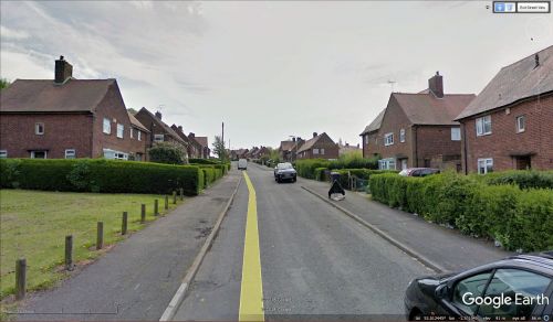
Sherwood Rise is a residential side street of Plumptre Way in Eastwood. As it is not included on earlier O.S. maps, it probably dates from the last half of the 20th century.
Gazetteers
- Not included in Dobson, R. B., ed.; Taylor, J., ed. Rymes of Robyn Hood: an Introduction to the English Outlaw (London, 1976), pp. 293-311.
Maps
- 25" O.S. map Nottinghamshire XXXVII.2 (1880; surveyed 1878)
- 25" O.S. map Nottinghamshire XXXVII.2 (1900; rev. 1899)
- 25" O.S. map Nottinghamshire XXXVII.2 (1900; rev. 1899) (georeferenced)
- 25" O.S. map Nottinghamshire XXXVII.2 (1915; rev. 1913)
- 25" O.S. map Nottinghamshire XXXVII.2 (1947; rev. 1938)
- 6" O.S. map Nottinghamshire XXXVII.NW (1885; surveyed 1879-80)
- 6" O.S. map Derbyshire XLVI.NW (1901; rev. 1899)
- 6" O.S. map Derbyshire XLVI.NW (1901; rev. 1899) (georeferenced)
- 6" O.S. map Derbyshire XLVI (1921; rev. 1913-14)
- 6" O.S. map Derbyshire XLVI.NW (1921; rev. 1913)
- 6" O.S. map Derbyshire XLVI.NW (c. 1947; rev. 1938).
Also see

