Robinhood Farm (Lostock Gralam): Difference between revisions
From International Robin Hood Bibliography
m (Text replacement - "Category:Place-Names-topics" to "Category:Place-names-topics") |
m (Text replacement - "* 25" map" to "* 25" O.S. map") |
||
| (36 intermediate revisions by the same user not shown) | |||
| Line 1: | Line 1: | ||
__NOTOC__ | __NOTOC__{{PlaceNamesItemTop|Lat=53.2604|Lon=-2.4598|AdministrativeDivision=Cheshire|Vicinity=Birches Lane, Lostock Green, ''c.'' 1 km south of Lostock Gralam|Type=Building|Interest=Robin Hood name|Status=Defunct|Demonym=|Riding=|GreaterLondon=|Year=1882|Aka=|Century=|Cluster1=Lostock Gralam|Cluster2=|Cluster3=|Image=|Postcards=|ExtraCat1=Robinhood place-names|ExtraCat2=|ExtraCat3=|ExtraCat4=|ExtraCat5=|ExtraLink1=|ExtraLink2=|ExtraLink3=|ExtraLink4=|ExtraLink5=|ExtraLinkName1=|ExtraLinkName2=|ExtraLinkName3=|ExtraLinkName4=|ExtraLinkName5=|GeopointPrefix=|GeopointSuffix=|StatusSuffix=|DatePrefix=|DateSuffix=}} | ||
{{ | {{#display_map:{{#var:Coords}}~{{#replace:{{PAGENAME}}|'|'}}|width=34%|enablefullscreen=yes}}<div class="pnMapLegend">The site of Robinhood Farm.</div> | ||
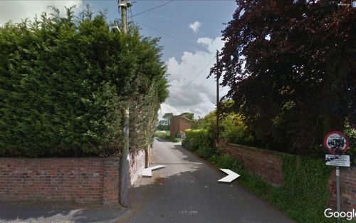
[[File:robinhood-farm-lostock-gralam-google-earth-street-view.jpg|thumb|right|500px|Looking down Birches Lane. Did the building, centre mid-distance, belong to Robinhood Farm? / Google Earth Street View.]] | |||
<div class="no-img"> | |||
<p id="byline">By Henrik Thiil Nielsen, 2017-01-17. Revised by {{#realname:{{REVISIONUSER}}}}, {{REVISIONYEAR}}-{{REVISIONMONTH}}-{{REVISIONDAY2}}.</p> | |||
Robinhood Farm was located on Birches Lane in Lostock Green, a hamlet in Lostock Gralam, situated about 1 km south of the main town of the parish. The name is found on a 6" O.S. map of the area published in 1882, based on a survey carried out 1874-77. This is the earliest occurrence found so far. | |||
The English Place-Name Society's volume on this part of Cheshire lists Robinhood Farm without source reference or date,<ref>{{:Dodgson, John McNeal 1970a}}, vol. II, p. 191.</ref> which suggests that the editor of the volume thought it likely to be of modern date. Robinhood Farm is included on all the O.S. maps listed below. | |||
<!--== Allusions == | |||
{{#ask:[[Category:Allusions (Robinhood Farm, Lostock Gralam)]]|format=embedded|embedformat=h3|columns=1|limit=1000|sort=Utitle}}--> | |||
== Gazetteers == | |||
}} | |||
{{# | |||
<p id="byline">By Henrik Thiil Nielsen, 2017-01-17. Revised by {{#realname:{{REVISIONUSER}}}}, {{REVISIONYEAR}}-{{REVISIONMONTH}}-{{REVISIONDAY2}}.</p | |||
Robinhood Farm was located in Lostock Green, a hamlet in Lostock Gralam, situated about 1 km south of the main town of the parish. The English Place-Name Society's volume on this part of Cheshire lists | |||
<!-- | |||
{{#ask:[[Category:Allusions (Robinhood Farm, Lostock Gralam)]]|format=embedded|embedformat= | |||
* Not included in {{:Dobson, Richard Barrie 1976a}}, pp. 293-311. | * Not included in {{:Dobson, Richard Barrie 1976a}}, pp. 293-311. | ||
== Sources == | |||
* {{:Dodgson, John McNeal 1970a}}, vol. II, pp. 190, 191. | * {{:Dodgson, John McNeal 1970a}}, vol. II, pp. 190, 191. | ||
=== | == Maps == | ||
* [https://maps.nls.uk/geo/explore/#zoom=17&lat=53.26108&lon=-2.46069&layers=168&b=5 25" O.S. map ''Cheshire'' XXXIV.7 (1898; rev. 1897)] (georeferenced) | |||
* [https://maps.nls.uk/view/114583249#zoom=5&lat=1352&lon=5843&layers=BT 25" O.S. map ''Cheshire'' XXXIV.7 (1898; rev. 1897)] | |||
* 25" O.S. map ''Cheshire'' XXXIV.7 (''c.'' 1877; surveyed ''c.'' 1872). No copy in NLS | |||
* [https://maps.nls.uk/view/114583252#zoom=5&lat=1125&lon=6302&layers=BT 25" O.S. map ''Cheshire'' XXXIV.7 (1910; rev. 1908).] | |||
* [http://maps.nls.uk/view/102341056#zoom=5&lat=5441&lon=9047&layers=BT 6" O.S. map ''Cheshire'' XXXIV (1882; surveyed 1874-77)] | * [http://maps.nls.uk/view/102341056#zoom=5&lat=5441&lon=9047&layers=BT 6" O.S. map ''Cheshire'' XXXIV (1882; surveyed 1874-77)] | ||
* [http://maps.nls.uk/view/101598799#zoom=5&lat=1518&lon=2165&layers=BT 6" O.S. map ''Cheshire'' XXXIV.NE (1899; rev. 1897)] | * [http://maps.nls.uk/view/101598799#zoom=5&lat=1518&lon=2165&layers=BT 6" O.S. map ''Cheshire'' XXXIV.NE (1899; rev. 1897)] | ||
| Line 38: | Line 26: | ||
* [http://maps.nls.uk/view/101598793#zoom=5&lat=1727&lon=2236&layers=BT 6" O.S. map ''Cheshire'' XXXIV.NE (''c.'' 1945; rev. 1938)] | * [http://maps.nls.uk/view/101598793#zoom=5&lat=1727&lon=2236&layers=BT 6" O.S. map ''Cheshire'' XXXIV.NE (''c.'' 1945; rev. 1938)] | ||
== Background == | |||
* [https://en.wikipedia.org/wiki/Lostock_Gralam Lostock Gralam.] | * [https://en.wikipedia.org/wiki/Lostock_Gralam Lostock Gralam.] | ||
{{PlaceNamesItemAlsoSee}} | |||
== Notes == | |||
<references/> | <references/> | ||
</div> | </div> | ||
{{PlaceNamesItemNavigation}} | |||
{{ | |||
Latest revision as of 16:44, 8 May 2022
| Locality | |
|---|---|
| Coordinate | 53.2604, -2.4598 |
| Adm. div. | Cheshire |
| Vicinity | Birches Lane, Lostock Green, c. 1 km south of Lostock Gralam |
| Type | Building |
| Interest | Robin Hood name |
| Status | Defunct |
| First Record | 1882 |
The site of Robinhood Farm.
By Henrik Thiil Nielsen, 2017-01-17. Revised by Henrik Thiil Nielsen, 2022-05-08.
Robinhood Farm was located on Birches Lane in Lostock Green, a hamlet in Lostock Gralam, situated about 1 km south of the main town of the parish. The name is found on a 6" O.S. map of the area published in 1882, based on a survey carried out 1874-77. This is the earliest occurrence found so far.
The English Place-Name Society's volume on this part of Cheshire lists Robinhood Farm without source reference or date,[1] which suggests that the editor of the volume thought it likely to be of modern date. Robinhood Farm is included on all the O.S. maps listed below.
Gazetteers
- Not included in Dobson, R. B., ed.; Taylor, J., ed. Rymes of Robyn Hood: an Introduction to the English Outlaw (London, 1976), pp. 293-311.
Sources
- Dodgson, John McN.; Rumble, Alexander R. The Place-Names of Cheshire, pts. I-V (English Place-Name Society, vols. XLIV-XLVIII, LIV, LXXIV) (Cambridge, 1970-72; [s.l.], 1981; Nottingham, 1997), vol. II, pp. 190, 191.
Maps
- 25" O.S. map Cheshire XXXIV.7 (1898; rev. 1897) (georeferenced)
- 25" O.S. map Cheshire XXXIV.7 (1898; rev. 1897)
- 25" O.S. map Cheshire XXXIV.7 (c. 1877; surveyed c. 1872). No copy in NLS
- 25" O.S. map Cheshire XXXIV.7 (1910; rev. 1908).
- 6" O.S. map Cheshire XXXIV (1882; surveyed 1874-77)
- 6" O.S. map Cheshire XXXIV.NE (1899; rev. 1897)
- 6" O.S. map Cheshire XXXIV.NE (1899; rev. 1897) (georeferenced)
- 6" O.S. map Cheshire XXXIV.NE (1911; rev. 1908)
- 6" O.S. map Cheshire XXXIV.NE (c. 1945; rev. 1938)
Background
Also see
Notes

