
Robinhood End (Finchingfield): Difference between revisions
From International Robin Hood Bibliography
m (Text replacement - "embedformat=h4" to "embedformat=h3") |
m (Text replacement - "{{#ask:[[Category:Records ({{#ifeq:{{#pos:{{PAGENAME}}|(|}}||{{PAGENAME}}|{{#sub:{{PAGENAME}}|0| {{#expr:{{#pos:{{PAGENAME}}|(|}}-1}} }},{{#sub:{{PAGENAME}}|{{#expr:{{#pos:{{PAGENAME}}|(|}}-1}}|1}}{{#sub:{{PAGENAME}}|{{#expr:{{#pos:...) |
||
| Line 5: | Line 5: | ||
<p id="byline">By Henrik Thiil Nielsen, 2016-06-25. Revised by {{#realname:{{REVISIONUSER}}}}, {{REVISIONYEAR}}-{{REVISIONMONTH}}-{{REVISIONDAY2}}.</p> | <p id="byline">By Henrik Thiil Nielsen, 2016-06-25. Revised by {{#realname:{{REVISIONUSER}}}}, {{REVISIONYEAR}}-{{REVISIONMONTH}}-{{REVISIONDAY2}}.</p> | ||
<div class="no-img"> | <div class="no-img"> | ||
Robinhood End is a hamlet located 4.36 km NNE of Finchingfield. The place-name is first recorded, as "Robyne Hoods End", in a deed dated 1699.<ref>{{:Reaney, Percy Hide 1969a}}, p. 428. The deed was unpublished and in a private collection as of 1969, cf. ''ibid.'', p. xli.</ref> It is indicated on John Chapman and Peter André's 1777 map of Essex (see Maps section and illustration below) as 'Robin Hoods end'. About 600 m. NNE of the hamlet is [[Robinhood End Farm (Finchingfield)|Robinhood End Farm]].{{#ask:[[Category:Records ({{#ifeq:{{#pos:{{PAGENAME}}|(|}}||{{PAGENAME}}|{{#sub:{{PAGENAME}}|0| {{#expr:{{#pos:{{PAGENAME}}|(|}}-1}} }},{{#sub:{{PAGENAME}}|{{#expr:{{#pos:{{PAGENAME}}|(|}}-1}}|1}}{{#sub:{{PAGENAME}}|{{#expr:{{#pos:{{PAGENAME}}|(|}}+1}}}}}}]]| format=embedded|embedformat=h3|columns=1|limit=1000|sort=Utitle|intro=<h2>Records</h2>}}{{#ask:[[Category:Allusions ({{#ifeq:{{#pos:{{PAGENAME}}|(|}}||{{PAGENAME}}|{{#sub:{{PAGENAME}}|0| {{#expr:{{#pos:{{PAGENAME}}|(|}}-1}} }},{{#sub:{{PAGENAME}}|{{#expr:{{#pos:{{PAGENAME}}|(|}}-1}}|1}}{{#sub:{{PAGENAME}}|{{#expr:{{#pos:{{PAGENAME}}|(|}}+1}}}}}}]]| format=embedded|embedformat=h3|columns=1|limit=1000|sort=Utitle|intro=<h2>Allusions</h2>}} | Robinhood End is a hamlet located 4.36 km NNE of Finchingfield. The place-name is first recorded, as "Robyne Hoods End", in a deed dated 1699.<ref>{{:Reaney, Percy Hide 1969a}}, p. 428. The deed was unpublished and in a private collection as of 1969, cf. ''ibid.'', p. xli.</ref> It is indicated on John Chapman and Peter André's 1777 map of Essex (see Maps section and illustration below) as 'Robin Hoods end'. About 600 m. NNE of the hamlet is [[Robinhood End Farm (Finchingfield)|Robinhood End Farm]].{{#ask:[[Category:Records ({{#ifeq:{{#pos:{{PAGENAME}}|(|}}||{{PAGENAME}}|{{#sub:{{PAGENAME}}|0| {{#expr:{{#pos:{{PAGENAME}}|(|}}-1}} }},{{#sub:{{PAGENAME}}|{{#expr:{{#pos:{{PAGENAME}}|(|}}-1}}|1}}{{#sub:{{PAGENAME}}|{{#expr:{{#pos:{{PAGENAME}}|(|}}+1}}}}}}]]| format=embedded|embedformat=h3|columns=1|limit=1000|sort=Utitle|intro=<h2>Records</h2><div class="mw-collapsible mw-collapsed records" data-expandtext="Show records" data-collapsetext="Hide records">|outro=</div>}}{{#ask:[[Category:Allusions ({{#ifeq:{{#pos:{{PAGENAME}}|(|}}||{{PAGENAME}}|{{#sub:{{PAGENAME}}|0| {{#expr:{{#pos:{{PAGENAME}}|(|}}-1}} }},{{#sub:{{PAGENAME}}|{{#expr:{{#pos:{{PAGENAME}}|(|}}-1}}|1}}{{#sub:{{PAGENAME}}|{{#expr:{{#pos:{{PAGENAME}}|(|}}+1}}}}}}]]| format=embedded|embedformat=h3|columns=1|limit=1000|sort=Utitle|intro=<h2>Allusions</h2><div class="mw-collapsible mw-collapsed allusions" data-expandtext="Show allusionss" data-collapsetext="Hide allusions">|outro=</div>}} | ||
== Gazetteers == | == Gazetteers == | ||
* {{:Dobson, Richard Barrie 1976a}}, p. 297, ''s.n.'' Robinhood End. | * {{:Dobson, Richard Barrie 1976a}}, p. 297, ''s.n.'' Robinhood End. | ||
Revision as of 02:56, 17 July 2018
Robin Hood End.


Detail from Chapman and André's Map of Essex (1777). To the left, Robinhood End Farm ('Robin Hoods Farm') and Robin Hood End / From superb scan of entire map by Biblioteca Virtual del Patrimoni Bibliogràfico) (click picture to enlarge.)
By Henrik Thiil Nielsen, 2016-06-25. Revised by Henrik Thiil Nielsen, 2018-07-17.
Robinhood End is a hamlet located 4.36 km NNE of Finchingfield. The place-name is first recorded, as "Robyne Hoods End", in a deed dated 1699.[1] It is indicated on John Chapman and Peter André's 1777 map of Essex (see Maps section and illustration below) as 'Robin Hoods end'. About 600 m. NNE of the hamlet is Robinhood End Farm.
Gazetteers
- Dobson, R. B., ed.; Taylor, J., ed. Rymes of Robyn Hood: an Introduction to the English Outlaw (London, 1976), p. 297, s.n. Robinhood End.
Sources
- Reaney, P.H. The Place-Names of Essex (English Place-Name Society, vol. XII) (Cambridge, 1969), p. 428.
Maps
- Chapman, John, cartog.; André, Peter, cartog. A Map of the County of Essex: from an Actual Survey Taken in MDCCLXXII, LXXIII & MDCCLXXIV (London, 1777), plate III.
- 6" O.S. map of Essex X (1880, surveyed 1876-77)
- 6" O.S. map of Essex X.SE (1898, rev. 1896.)
Notes
- ↑ Reaney, P.H. The Place-Names of Essex (English Place-Name Society, vol. XII) (Cambridge, 1969), p. 428. The deed was unpublished and in a private collection as of 1969, cf. ibid., p. xli.
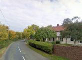
Downtown Robinhood End / Google Earth Street View.
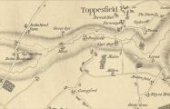
Detail from Chapman and André's Map of Essex (1777) / Superb scan of entire map by Biblioteca Virtual del Patrimoni Bibliogràfico).