
Robin Wood's Rock (Beadnell Bay): Difference between revisions
m (Text replacement - "VicinitySuffix=|" to "") |
m (Text replacement - ".</p><div class="no-img">" to ".</p> <div class="no-img">") |
||
| Line 2: | Line 2: | ||
{{#display_map:{{#var:Coords}}|width=34%}}<div class="pnMapLegend">Robin Wood's Rock.</div> | {{#display_map:{{#var:Coords}}|width=34%}}<div class="pnMapLegend">Robin Wood's Rock.</div> | ||
[[File:robin-woods-rock-beadnell-bay-google-earth.jpg|thumb|right|500px|Robin Wood's Rock from the air / Google Earth Street View.]] | [[File:robin-woods-rock-beadnell-bay-google-earth.jpg|thumb|right|500px|Robin Wood's Rock from the air / Google Earth Street View.]] | ||
<p id="byline">By Henrik Thiil Nielsen, 2017-05-09. Revised by {{#realname:{{REVISIONUSER}}}}, {{REVISIONYEAR}}-{{REVISIONMONTH}}-{{REVISIONDAY2}}.</p><div class="no-img"> | <p id="byline">By Henrik Thiil Nielsen, 2017-05-09. Revised by {{#realname:{{REVISIONUSER}}}}, {{REVISIONYEAR}}-{{REVISIONMONTH}}-{{REVISIONDAY2}}.</p> | ||
<div class="no-img"> | |||
Robin Wood's Rock is a whin point in the North Sea, ''c.'' 480 meters from the coast at high tide, ''c.'' 140 meters at low tide, in Beadnell Bay, Northumberland. As Dobson & Taylor note, 'Wood' was a not uncommon alternative for 'Hood' in the 17th and 18th centuries.<ref>{{:Dobson, Richard Barrie 1976a}}, p. 300, ''s.n.'' Robin Hood's Rock.</ref> For other examples of 'Wood' for 'Hood', see the page on [[Wood for Hood]]. A standard work on the coastal geography of England and Wales cites the name of this locality as 'Robin Hood's Rock'.<ref>{{:Steers, J A 1946a}}, p. 454.</ref> So far the earliest reference I have is the 6" O.S. map of the area published in 1886 (see Maps section below). | Robin Wood's Rock is a whin point in the North Sea, ''c.'' 480 meters from the coast at high tide, ''c.'' 140 meters at low tide, in Beadnell Bay, Northumberland. As Dobson & Taylor note, 'Wood' was a not uncommon alternative for 'Hood' in the 17th and 18th centuries.<ref>{{:Dobson, Richard Barrie 1976a}}, p. 300, ''s.n.'' Robin Hood's Rock.</ref> For other examples of 'Wood' for 'Hood', see the page on [[Wood for Hood]]. A standard work on the coastal geography of England and Wales cites the name of this locality as 'Robin Hood's Rock'.<ref>{{:Steers, J A 1946a}}, p. 454.</ref> So far the earliest reference I have is the 6" O.S. map of the area published in 1886 (see Maps section below). | ||
<!--{{#ask:[[Category:Records (_PLACE-NAME)]]| format=embedded|embedformat=h4| columns=1|limit=1000|sort=Utitle}}--> | <!--{{#ask:[[Category:Records (_PLACE-NAME)]]| format=embedded|embedformat=h4| columns=1|limit=1000|sort=Utitle}}--> | ||
Revision as of 12:29, 18 December 2017

By Henrik Thiil Nielsen, 2017-05-09. Revised by Henrik Thiil Nielsen, 2017-12-18.
Robin Wood's Rock is a whin point in the North Sea, c. 480 meters from the coast at high tide, c. 140 meters at low tide, in Beadnell Bay, Northumberland. As Dobson & Taylor note, 'Wood' was a not uncommon alternative for 'Hood' in the 17th and 18th centuries.[1] For other examples of 'Wood' for 'Hood', see the page on Wood for Hood. A standard work on the coastal geography of England and Wales cites the name of this locality as 'Robin Hood's Rock'.[2] So far the earliest reference I have is the 6" O.S. map of the area published in 1886 (see Maps section below).
Gazetteers
- Dobson, R. B., ed.; Taylor, J., ed. Rymes of Robyn Hood: an Introduction to the English Outlaw (London, 1976), p. 300, s.n. Robin Hood's Rock.
Sources
Maps
- 6" O.S. map Northumberland XXII (1866; surveyed 1860)
- 6" O.S. map Northumberland XXII.SE (1899; rev. 1896)
- 6" O.S. map Northumberland XXII.SE (1899; rev. 1896) (georeferenced)
- 6" O.S. map Northumberland nXVIII.SE (1925; rev. 1922)
Background
Notes
- ↑ Dobson, R. B., ed.; Taylor, J., ed. Rymes of Robyn Hood: an Introduction to the English Outlaw (London, 1976), p. 300, s.n. Robin Hood's Rock.
- ↑ Steers, J.A. The Coastline of England and Wales (Cambridge, 1946), p. 454.
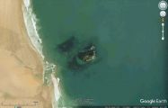
Robin Wood's Rock from the air / Google Earth Street View.
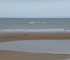
Robin Wood's Rock partly exposed by the ebbing tide / Russel Wills, Creative Commons via Geograph.
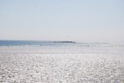
Robin Wood's Rock fully exposed by the low tide / N. Chadwick, Creative Commons via Geograph.

