
Robin Wood's Rock (Beadnell Bay): Difference between revisions
m (Text replacement - "|ExtraCat5=|" to "|ExtraCat5=|ExtraLink1=|ExtraLink2=|ExtraLink3=|ExtraLink4=|ExtraLink5=|ExtraLinkName1=|ExtraLinkName2=|ExtraLinkName3=|ExtraLinkName4=|ExtraLinkName5=|") |
m (Text replacement - "Creative Commons, via Geograph" to "Creative Commons via Geograph") |
||
| Line 38: | Line 38: | ||
{{ImgGalleryIntro}} | {{ImgGalleryIntro}} | ||
<gallery widths="195px">File:robin-woods-rock-beadnell-bay-google-earth.jpg|Robin Wood's Rock from the air / Google Earth Street View. | <gallery widths="195px">File:robin-woods-rock-beadnell-bay-google-earth.jpg|Robin Wood's Rock from the air / Google Earth Street View. | ||
File:geograph-robin-woods-rock-russel-wills.jpg|Robin Wood's Rock partly exposed by the ebbing tide / [http://www.geograph.ie/profile/23874 Russel Wills, Creative Commons | File:geograph-robin-woods-rock-russel-wills.jpg|Robin Wood's Rock partly exposed by the ebbing tide / [http://www.geograph.ie/profile/23874 Russel Wills, Creative Commons via Geograph.] | ||
File:geograph-robin-woods-rock-n-chadwick.jpg|thumb|right|500px|Robin Wood's Rock fully exposed by the low tide / [http://www.geograph.org.uk/profile/3101 N. Chadwick, Creative Commons | File:geograph-robin-woods-rock-n-chadwick.jpg|thumb|right|500px|Robin Wood's Rock fully exposed by the low tide / [http://www.geograph.org.uk/profile/3101 N. Chadwick, Creative Commons via Geograph.] | ||
</gallery> | </gallery> | ||
{{PnItemNav}} | {{PnItemNav}} | ||
Revision as of 22:05, 6 December 2017

By Henrik Thiil Nielsen, 2017-05-09. Revised by Henrik Thiil Nielsen, 2017-12-06.
Robin Wood's Rock is a whin point in the North Sea, c. 480 meters from the coast at high tide, c. 140 meters at low tide, in Beadnell Bay, Northumberland. As Dobson & Taylor note, 'Wood' was a not uncommon alternative for 'Hood' in the 17th and 18th centuries.[1] For other examples of 'Wood' for 'Hood', see the page on Wood for Hood. A standard work on the coastal geography of England and Wales cites the name of this locality as 'Robin Hood's Rock'.[2] So far the earliest reference I have is the 6" O.S. map of the area published in 1886 (see Maps section below).
Gazetteers
- Dobson, R. B., ed.; Taylor, J., ed. Rymes of Robyn Hood: an Introduction to the English Outlaw (London, 1976), p. 300, s.n. Robin Hood's Rock.
Sources
Maps
- 6" O.S. map Northumberland XXII (1866; surveyed 1860)
- 6" O.S. map Northumberland XXII.SE (1899; rev. 1896)
- 6" O.S. map Northumberland XXII.SE (1899; rev. 1896) (georeferenced)
- 6" O.S. map Northumberland nXVIII.SE (1925; rev. 1922)
Background
Notes
- ↑ Dobson, R. B., ed.; Taylor, J., ed. Rymes of Robyn Hood: an Introduction to the English Outlaw (London, 1976), p. 300, s.n. Robin Hood's Rock.
- ↑ Steers, J.A. The Coastline of England and Wales (Cambridge, 1946), p. 454.
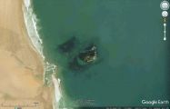
Robin Wood's Rock from the air / Google Earth Street View.
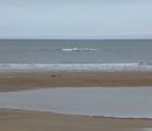
Robin Wood's Rock partly exposed by the ebbing tide / Russel Wills, Creative Commons via Geograph.
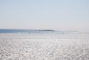
Robin Wood's Rock fully exposed by the low tide / N. Chadwick, Creative Commons via Geograph.

