
Robin Hood and Little John (Walton Highway): Difference between revisions
m (Text replacement - "{{#display_map:{{#var:Coords}}|" to "{{#display_map:{{#var:Coords}}~{{PAGENAME}}|") |
m (Text replacement - "ImgGalleryIntro" to "ImageGalleryIntroduction") |
||
| (28 intermediate revisions by 2 users not shown) | |||
| Line 1: | Line 1: | ||
__NOTOC__{{ | __NOTOC__{{PlaceNamesItemTop|Lat=52.6945|Lon=0.2058|AdministrativeDivision=Norfolk|Vicinity=On Lynn Road, Walton Highway, West Walton|Type=Public house|Interest=Robin Hood name|Status=Defunct|Demonym=|Riding=|GreaterLondon=|Year=1861|Aka=|Century=|Cluster1=|Cluster2=|Cluster3=|Image=robin-hood-and-little-john-walton-highway-google-earth-street-view.jpg|Postcards=|ExtraCat1=Places named after Little John|ExtraCat2=|ExtraCat3=|ExtraCat4=|ExtraCat5=|ExtraLink1=|ExtraLink2=|ExtraLink3=|ExtraLink4=|ExtraLink5=|ExtraLinkName1=|ExtraLinkName2=|ExtraLinkName3=|ExtraLinkName4=|ExtraLinkName5=|GeopointPrefix=|GeopointSuffix=|StatusSuffix=|DatePrefix=|DateSuffix=}} | ||
{{#display_map:{{#var:Coords}}~{{PAGENAME}}|width=34%}}<div class="pnMapLegend">The Highway man, formerly Robin Hood and Little John..</div> | {{#display_map:{{#var:Coords}}~{{#replace:{{PAGENAME}}|'|'}}|width=34%|enablefullscreen=yes}}<div class="pnMapLegend">The Highway man, formerly Robin Hood and Little John..</div> | ||
[[File:robin-hood-and-little-john-walton-highway-google-earth-street-view.jpg|thumb|right|500px|Robin Hood and Little John have given way to the Highway Man / Google Earth Street View.]] | [[File:robin-hood-and-little-john-walton-highway-google-earth-street-view.jpg|thumb|right|500px|Robin Hood and Little John have given way to the Highway Man / Google Earth Street View.]]<div class="no-img"> | ||
<p id="byline">By Henrik Thiil Nielsen, 2017-09-24. Revised by {{#realname:{{REVISIONUSER}}}}, {{REVISIONYEAR}}-{{REVISIONMONTH}}-{{REVISIONDAY2}}.</p> | <p id="byline">By Henrik Thiil Nielsen, 2017-09-24. Revised by {{#realname:{{REVISIONUSER}}}}, {{REVISIONYEAR}}-{{REVISIONMONTH}}-{{REVISIONDAY2}}.</p> | ||
'Robin Hood and Little John' was the former name of a pub now named 'The Highway Man' in Walton Highway, West Walton, Norfolk, not far from the pre-1972 Cambridgeshire/Norfolk county boundary. According to the 1861 census as well as that of 1871, the publicans were then Robert and Elizabeth Gathergood.<ref>[Cambridgeshire Community Archive Network: Wisbech: The Robin Hood public house, Walton Highway.]</ref> Probably the name of the pub was already at that time 'Robin Hood and Little John'. It is found under this name on an 1887 O.S. 6" map of Norfolk. Later 6" O.S. maps indicate a public house but do not include its name. Richard Humphrey in the information provided with his 2010 photo (see Image Gallery below) notes that the Highway Man was "[f]ormerly called The Robin Hood".<ref>[http://www.geograph.org.uk/photo/2182330 Geograph: TF4913 : The Highwayman pub, Walton Highway.]</ref> I do not know when the pub lost its Robin Hood moniker, but there is a Facebook page – though without any contents – for the pub under its previous name, and as Facebook came online in 2004, this cannot have been very long before 2010.<ref>[https://www.facebook.com/pages/Robin-Hood-and-Little-John-Walton-Highway/629090340454932 Facebook: Robin Hood and Little John Walton Highway.]</ref>{{PlaceNamesItemAllusionsAndRecords}} | |||
'Robin Hood and Little John' was the former name of a pub now named 'The Highway Man' in Walton Highway, West Walton, Norfolk, not far from the pre-1972 Cambridgeshire/Norfolk county boundary. According to the 1861 census as well as that of 1871, the publicans were then Robert and Elizabeth Gathergood.<ref>[Cambridgeshire Community Archive Network: Wisbech: The Robin Hood public house, Walton Highway.]</ref> Probably the name of the pub was already at that time 'Robin Hood and Little John'. It is found under this name on an 1887 O.S. 6" map of Norfolk. Later 6" O.S. maps indicate a public house but do not include its name. Richard Humphrey in the information provided with his 2010 photo (see Image Gallery below) notes that the Highway Man was "[f]ormerly called The Robin Hood".<ref>[http://www.geograph.org.uk/photo/2182330 Geograph: TF4913 : The Highwayman pub, Walton Highway.]</ref> I do not know when the pub lost its Robin Hood moniker, but there is a | == Gazetteers == | ||
* Not included in {{:Dobson, Richard Barrie 1976a}}, pp. 293-311. | * Not included in {{:Dobson, Richard Barrie 1976a}}, pp. 293-311. | ||
== Sources == | |||
* [http://wisbech.ccan.co.uk/content/catalogue_item/the-robin-hood-public-house-walton-highway Cambridgeshire Community Archive Network: Wisbech: The Robin Hood public house, Walton Highway] | * [http://wisbech.ccan.co.uk/content/catalogue_item/the-robin-hood-public-house-walton-highway Cambridgeshire Community Archive Network: Wisbech: The Robin Hood public house, Walton Highway] | ||
* [https://www.facebook.com/pages/Robin-Hood-and-Little-John-Walton-Highway/629090340454932 | * [https://www.facebook.com/pages/Robin-Hood-and-Little-John-Walton-Highway/629090340454932 Facebook: Robin Hood and Little John Walton Highway.] | ||
== Maps == | |||
Public house indicated on all the maps, but the name 'Robin Hood & Little John' only on the 1887 Norfolk map. | Public house indicated on all the maps, but the name 'Robin Hood & Little John' only on the 1887 Norfolk map. | ||
* [http://maps.nls.uk/view/101581997#zoom=6&lat=4698&lon=7856&layers=BT 6" O.S. map ''Norfolk'' XLIII.SE (1887; surveyed 1886)] | * [http://maps.nls.uk/view/101581997#zoom=6&lat=4698&lon=7856&layers=BT 6" O.S. map ''Norfolk'' XLIII.SE (1887; surveyed 1886)] | ||
| Line 21: | Line 20: | ||
* [http://maps.nls.uk/view/101570572#zoom=5&lat=4967&lon=7934&layers=BT 6" O.S. map ''Cambridgeshire'' IV.SE (1952; rev. 1950).] | * [http://maps.nls.uk/view/101570572#zoom=5&lat=4967&lon=7934&layers=BT 6" O.S. map ''Cambridgeshire'' IV.SE (1952; rev. 1950).] | ||
== Background == | |||
* [https://en.wikipedia.org/wiki/West_Walton Wikipedia: West Walton.] | * [https://en.wikipedia.org/wiki/West_Walton Wikipedia: West Walton.] | ||
{{ | {{PlaceNamesItemAlsoSee}} | ||
* [[Places named after Little John]]. | * [[Places named after Little John]]. | ||
== Notes == | |||
<references/> | <references/> | ||
</div> | |||
<div id="gallery"> | |||
< | {{ImageGalleryIntroduction}} | ||
{{ | |||
<gallery widths="195px"> | <gallery widths="195px"> | ||
File:robin-hood-and-little-john-walton-highway-cambridgeshire-community-archive-network.jpg|The pub. Detail from a postcard believed to date from the period 1445-55 / [http://wisbech.ccan.co.uk/content/catalogue_item/the-robin-hood-public-house-walton-highway Cambridge Community Archive Network: The Robin Hood public house, Walton Highway.] | File:robin-hood-and-little-john-walton-highway-cambridgeshire-community-archive-network.jpg|The pub. Detail from a postcard believed to date from the period 1445-55 / [http://wisbech.ccan.co.uk/content/catalogue_item/the-robin-hood-public-house-walton-highway Cambridge Community Archive Network: The Robin Hood public house, Walton Highway.] | ||
| Line 38: | Line 37: | ||
File:robin-hood-and-little-john-walton-highway-j-thomas-geograph.jpg|The Highway Man / [http://www.geograph.org.uk/photo/4716915 J. Thomas, 23 Oct. 2015, Geograph, Creative Commons.] | File:robin-hood-and-little-john-walton-highway-j-thomas-geograph.jpg|The Highway Man / [http://www.geograph.org.uk/photo/4716915 J. Thomas, 23 Oct. 2015, Geograph, Creative Commons.] | ||
</gallery> | </gallery> | ||
</div> | |||
{{PlaceNamesItemNavigation}} | |||
{{ | |||
Latest revision as of 13:54, 7 January 2021
| Locality | |
|---|---|
| Coordinate | 52.6945, 0.2058 |
| Adm. div. | Norfolk |
| Vicinity | On Lynn Road, Walton Highway, West Walton |
| Type | Public house |
| Interest | Robin Hood name |
| Status | Defunct |
| First Record | 1861 |

By Henrik Thiil Nielsen, 2017-09-24. Revised by Henrik Thiil Nielsen, 2021-01-07.
'Robin Hood and Little John' was the former name of a pub now named 'The Highway Man' in Walton Highway, West Walton, Norfolk, not far from the pre-1972 Cambridgeshire/Norfolk county boundary. According to the 1861 census as well as that of 1871, the publicans were then Robert and Elizabeth Gathergood.[1] Probably the name of the pub was already at that time 'Robin Hood and Little John'. It is found under this name on an 1887 O.S. 6" map of Norfolk. Later 6" O.S. maps indicate a public house but do not include its name. Richard Humphrey in the information provided with his 2010 photo (see Image Gallery below) notes that the Highway Man was "[f]ormerly called The Robin Hood".[2] I do not know when the pub lost its Robin Hood moniker, but there is a Facebook page – though without any contents – for the pub under its previous name, and as Facebook came online in 2004, this cannot have been very long before 2010.[3]
Gazetteers
- Not included in Dobson, R. B., ed.; Taylor, J., ed. Rymes of Robyn Hood: an Introduction to the English Outlaw (London, 1976), pp. 293-311.
Sources
- Cambridgeshire Community Archive Network: Wisbech: The Robin Hood public house, Walton Highway
- Facebook: Robin Hood and Little John Walton Highway.
Maps
Public house indicated on all the maps, but the name 'Robin Hood & Little John' only on the 1887 Norfolk map.
- 6" O.S. map Norfolk XLIII.SE (1887; surveyed 1886)
- 6" O.S. map Cambridgeshire IV.SE (1903; rev. 1900-1901)
- 6" O.S. map Cambridgeshire IV.SE (1903; rev. 1900-1901) (georeferenced)
- 6" O.S. map Cambridgeshire IV.SE (1927; rev. 1926)
- 6" O.S. map Cambridgeshire IV.SE (c. 1933; rev. 1926)
- 6" O.S. map Cambridgeshire IV.SE (c. 1945; rev. 1938)
- 6" O.S. map Cambridgeshire IV.SE (1952; rev. 1950).
Background
Also see
Notes
- ↑ [Cambridgeshire Community Archive Network: Wisbech: The Robin Hood public house, Walton Highway.]
- ↑ Geograph: TF4913 : The Highwayman pub, Walton Highway.
- ↑ Facebook: Robin Hood and Little John Walton Highway.
Image gallery
Click any image to display it in the lightbox, where you can navigate between images by clicking in the right or left side of the current image.
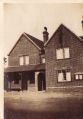
The pub. Detail from a postcard believed to date from the period 1445-55 / Cambridge Community Archive Network: The Robin Hood public house, Walton Highway.
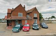
Robin Hood and Little John have given way to the Highway Man / Google Earth Street View.
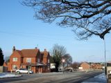
'The Highwayman pub, Walton Highway. Formerly called The Robin Hood' / Richard Humphrey, 1 Dec. 2010, Geograph, Creative Commons-
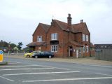
The Highway Man / J. Thomas, 23 Oct. 2015, Geograph, Creative Commons.


