
Robin Hood Spring (Allerston High Moor): Difference between revisions
m (Text replacement - "Creative Commons via Geograph" to "Creative Commons, via Geograph") |
m (Text replacement - "ImgGalleryIntro" to "ImageGalleryIntroduction") |
||
| (14 intermediate revisions by 2 users not shown) | |||
| Line 1: | Line 1: | ||
__NOTOC__{{ | __NOTOC__{{PlaceNamesItemTop|Lat=54.347890|Lon=-0.643140|AdministrativeDivision=Yorkshire|Vicinity=''c.'' 1.75 km SE of RAF Fylingdales|Type=Natural feature|Interest=Robin Hood name| | ||
Status=Extant|Demonym=English|Riding=North|GreaterLondon=|Year=1854|Aka=Robin Hood's Well|Century=19|Cluster1=|Cluster2=|Cluster3=|Image=robin-hood-spring-allerston-high-moor-google-earth-street-view.jpg|Postcards=<!--Any string means "Yes"-->|ExtraCat1=Places named Robin Hood's Well|ExtraCat2=|ExtraCat3=|ExtraCat4=|ExtraCat5=|ExtraLink1=|ExtraLink2=|ExtraLink3=|ExtraLink4=|ExtraLink5=|ExtraLinkName1=|ExtraLinkName2=|ExtraLinkName3=|ExtraLinkName4=|ExtraLinkName5=|GeopointPrefix=|GeopointSuffix=|VicinitySuffix=|StatusSuffix=|DatePrefix=|DateSuffix=}} | Status=Extant|Demonym=English|Riding=North|GreaterLondon=|Year=1854|Aka=Robin Hood's Well|Century=19|Cluster1=|Cluster2=|Cluster3=|Image=robin-hood-spring-allerston-high-moor-google-earth-street-view.jpg|Postcards=<!--Any string means "Yes"-->|ExtraCat1=Places named Robin Hood's Well|ExtraCat2=|ExtraCat3=|ExtraCat4=|ExtraCat5=|ExtraLink1=|ExtraLink2=|ExtraLink3=|ExtraLink4=|ExtraLink5=|ExtraLinkName1=|ExtraLinkName2=|ExtraLinkName3=|ExtraLinkName4=|ExtraLinkName5=|GeopointPrefix=|GeopointSuffix=|VicinitySuffix=|StatusSuffix=|DatePrefix=|DateSuffix=}} | ||
{{#display_map:{{#var:Coords}}~{{#replace:{{PAGENAME}}|'|'}}|width=34% | {{#display_map:{{#var:Coords}}~{{#replace:{{PAGENAME}}|'|'}}|width=34%|enablefullscreen=yes}}<div class="pnMapLegend">{{PAGENAME}}.</div> | ||
[[File:{{#var: | [[File:{{#var:Image}}|thumb|right|500px|The spring is in the area indicated / Google Earth Street View.]]<div class="no-img"> | ||
<p id="byline">By Henrik Thiil Nielsen, 2018-02-14. Revised by {{#realname:{{REVISIONUSER}}}}, {{REVISIONYEAR}}-{{REVISIONMONTH}}-{{REVISIONDAY2}}.</p | <p id="byline">By Henrik Thiil Nielsen, 2018-02-14. Revised by {{#realname:{{REVISIONUSER}}}}, {{REVISIONYEAR}}-{{REVISIONMONTH}}-{{REVISIONDAY2}}.</p> | ||
Robin Hood Spring is a natural well in Langdale Forest on Allerston High Moor. The name first occurs on a 6" map of the area published in 1854. | Robin Hood Spring is a natural well in Langdale Forest on Allerston High Moor. The name first occurs on a 6" map of the area published in 1854. | ||
It is possible that the pond in a forest clearing on Allerston High Moor in the photo from [http://www.geograph.org.uk/photo/316739 Geograph] in the image gallery below is in fact Robin Hood Spring or is fed by it. The [http://www.geograph.org.uk/showmap.php?gridref=SE883956 O.S. maplet accompanying the photo at Geograph] indicates that the pond is located where a path – of modern date judging by the general map evidence – traverses the area. As one would expect, the path does not actually lead right through a pond. In fact there is nothing along this stretch of the path that looks like a pond or well. The point indicated is just ''c.'' 50 m north of where Robin Hood's Spring is shown on the maps. What perhaps argues against identifying the pond with Robin Hood Spring is the slope behind the pond. In the area where Robin Hood Spring is supposed to be according to the maps, Google Earth indicates that ground level rarely varies more than about one meter.{{ | It is possible that the pond in a forest clearing on Allerston High Moor in the photo from [http://www.geograph.org.uk/photo/316739 Geograph] in the image gallery below is in fact Robin Hood Spring or is fed by it. The [http://www.geograph.org.uk/showmap.php?gridref=SE883956 O.S. maplet accompanying the photo at Geograph] indicates that the pond is located where a path – of modern date judging by the general map evidence – traverses the area. As one would expect, the path does not actually lead right through a pond. In fact there is nothing along this stretch of the path that looks like a pond or well. The point indicated is just ''c.'' 50 m north of where Robin Hood's Spring is shown on the maps. What perhaps argues against identifying the pond with Robin Hood Spring is the slope behind the pond. In the area where Robin Hood Spring is supposed to be according to the maps, Google Earth indicates that ground level rarely varies more than about one meter.{{PlaceNamesItemAllusionsAndRecords}} | ||
== Gazetteers == | == Gazetteers == | ||
* Not included in {{:Dobson, Richard Barrie 1976a}}, pp. 293-311 | * Not included in {{:Dobson, Richard Barrie 1976a}}, pp. 293-311 | ||
| Line 22: | Line 22: | ||
== Brief mention == | == Brief mention == | ||
* [https://megalithix.wordpress.com/sites/holy-wells/ Northern Antiquarian: Holy Wells, Healing Springs & Spas.] | * [https://megalithix.wordpress.com/sites/holy-wells/ Northern Antiquarian: Holy Wells, Healing Springs & Spas.] | ||
{{PlaceNamesItemAlsoSee}} | |||
</div> | |||
<div id="gallery"> | |||
{{ImageGalleryIntroduction}} | |||
< | |||
{{ | |||
<gallery widths="195px"> | <gallery widths="195px"> | ||
robin-hood-spring-allerston-high-moor-google-earth-street-view.jpg|The spring is in the area indicated / Google Earth Street View. | robin-hood-spring-allerston-high-moor-google-earth-street-view.jpg|The spring is in the area indicated / Google Earth Street View. | ||
geograph-316739-by-Mick-Garratt.jpg|Pond in Forest Clearing, Allerston High Moor. Is this the well? / [http://www.geograph.org.uk/photo/316739 Mick Garratt, 20 Jan. 2007, Creative Commons, via Geograph.] | geograph-316739-by-Mick-Garratt.jpg|Pond in Forest Clearing, Allerston High Moor. Is this the well? / [http://www.geograph.org.uk/photo/316739 Mick Garratt, 20 Jan. 2007, Creative Commons, via Geograph.] | ||
</gallery> | </gallery> | ||
</div> | |||
{{PlaceNamesItemNavigation}} | |||
{{ | |||
Latest revision as of 13:53, 7 January 2021
| Locality | |
|---|---|
| Coordinate | 54.34789, -0.64314 |
| Adm. div. | North Riding of Yorkshire |
| Vicinity | c. 1.75 km SE of RAF Fylingdales |
| Type | Natural feature |
| Interest | Robin Hood name |
| Status | Extant |
| First Record | 1854 |
| A.k.a. | Robin Hood's Well |

By Henrik Thiil Nielsen, 2018-02-14. Revised by Henrik Thiil Nielsen, 2021-01-07.
Robin Hood Spring is a natural well in Langdale Forest on Allerston High Moor. The name first occurs on a 6" map of the area published in 1854.
It is possible that the pond in a forest clearing on Allerston High Moor in the photo from Geograph in the image gallery below is in fact Robin Hood Spring or is fed by it. The O.S. maplet accompanying the photo at Geograph indicates that the pond is located where a path – of modern date judging by the general map evidence – traverses the area. As one would expect, the path does not actually lead right through a pond. In fact there is nothing along this stretch of the path that looks like a pond or well. The point indicated is just c. 50 m north of where Robin Hood's Spring is shown on the maps. What perhaps argues against identifying the pond with Robin Hood Spring is the slope behind the pond. In the area where Robin Hood Spring is supposed to be according to the maps, Google Earth indicates that ground level rarely varies more than about one meter.
Gazetteers
- Not included in Dobson, R. B., ed.; Taylor, J., ed. Rymes of Robyn Hood: an Introduction to the English Outlaw (London, 1976), pp. 293-311
- Northern Antiquarian: Holy Wells, Healing Springs & Spas.
Maps
- 6" O.S. map Yorkshire 61 (1854; surveyed 1848-49)
- 6" O.S. map Yorkshire LXI.SW (1895; surveyed 1889)
- 6" O.S. map Yorkshire LXI.SW (1914; rev. 1910)
- 6" O.S. map Yorkshire LXI.SW (1914; rev. 1910) (georeferenced)
- 6" O.S. map Yorkshire LXI.SW (1952; rev. 1950)
- 1:25,000 O.S. map 'SE89 (1954; surveyed 1950) (georeferenced)
- 1:1 million–1-10k O.S. map SE883955 (1900s) (georeferenced).
Brief mention
Also see
Image gallery
Click any image to display it in the lightbox, where you can navigate between images by clicking in the right or left side of the current image.
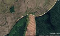
The spring is in the area indicated / Google Earth Street View.
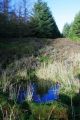
Pond in Forest Clearing, Allerston High Moor. Is this the well? / Mick Garratt, 20 Jan. 2007, Creative Commons, via Geograph.
