Robin Hood Sidings (Robin Hood, Wakefield): Difference between revisions
From International Robin Hood Bibliography
m (Text replacement - "{{#var:Coords}}~{{PAGENAME}}" to "{{#var:Coords}}~{{#replace:{{PAGENAME}}|'|'}}") |
m (Text replacement - "=== Maps ===" to "== Maps ==") |
||
| Line 6: | Line 6: | ||
Robin Hood Sidings in the village of Robin Hood, Wakefield, on the East and West Yorkshire Union Railway, are first recorded, as far as I know, on the 6" O.S. map of the area published in 1894. The railway was established in 1891 and extended a few years later. It closed in 1966.<ref>[http://www.lner.info/co/EWYUR/history.php The London & North Eastern Railway Encyclopedia: Brief History of the EWYUR.]</ref> | Robin Hood Sidings in the village of Robin Hood, Wakefield, on the East and West Yorkshire Union Railway, are first recorded, as far as I know, on the 6" O.S. map of the area published in 1894. The railway was established in 1891 and extended a few years later. It closed in 1966.<ref>[http://www.lner.info/co/EWYUR/history.php The London & North Eastern Railway Encyclopedia: Brief History of the EWYUR.]</ref> | ||
== Maps == | |||
* [http://maps.nls.uk/view/102345004#zoom=6&lat=7702&lon=8230&layers=BT 6" O.S. map ''Yorkshire'' 233 (1854; rev. 1848-51)] | * [http://maps.nls.uk/view/102345004#zoom=6&lat=7702&lon=8230&layers=BT 6" O.S. map ''Yorkshire'' 233 (1854; rev. 1848-51)] | ||
* [http://maps.nls.uk/view/100947707#zoom=6&lat=3701&lon=1656&layers=BT 6" O.S. map ''Yorkshire'' CCXXXIII.NE (1894; rev. 1892)] | * [http://maps.nls.uk/view/100947707#zoom=6&lat=3701&lon=1656&layers=BT 6" O.S. map ''Yorkshire'' CCXXXIII.NE (1894; rev. 1892)] | ||
Revision as of 14:37, 12 July 2018
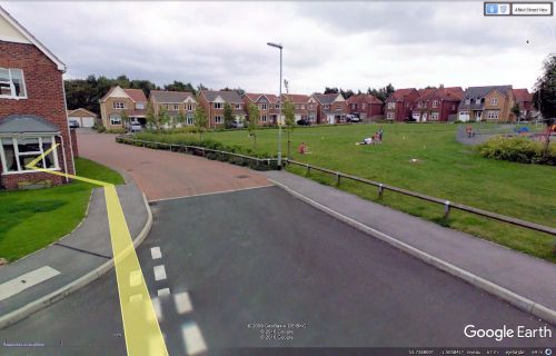
Site of Robin Hood Sidings.
By Henrik Thiil Nielsen, 2016-12-31. Revised by Henrik Thiil Nielsen, 2018-07-12.
Robin Hood Sidings in the village of Robin Hood, Wakefield, on the East and West Yorkshire Union Railway, are first recorded, as far as I know, on the 6" O.S. map of the area published in 1894. The railway was established in 1891 and extended a few years later. It closed in 1966.[1]
Maps
- 6" O.S. map Yorkshire 233 (1854; rev. 1848-51)
- 6" O.S. map Yorkshire CCXXXIII.NE (1894; rev. 1892)
- 6" O.S. map Yorkshire CCXXXIII.NE (1908; rev. 1905)
- 6" O.S. map Yorkshire CCXXXIII.NE (1908; rev. 1905) (georeferenced)
- 6" O.S. map Yorkshire CCXXXIII.NE (1931; rev. 1931-32) [sic]
- 6" O.S. map Yorkshire CCXXXIII.NE (1947; rev. 1938)
- 6" O.S. map Yorkshire CCXXXIII.NE (1949; rev. 1948).
Background
Notes

