Robin Hood Lodge (Sutton): Difference between revisions
From International Robin Hood Bibliography
m (Text replacement - "PlaceNamesItemQuery" to "PlaceNamesItemAllusionsAndRecords") |
m (Text replacement - "No Copy in NLS" to "No copy in NLS") |
||
| (One intermediate revision by the same user not shown) | |||
| Line 8: | Line 8: | ||
<!--== Sources ==--> | <!--== Sources ==--> | ||
== Maps == | == Maps == | ||
* 25" O.S. map ''Surrey'' XIII.11 (''c.'' 1873; surveyed ''c.'' 1866-67). No | * 25" O.S. map ''Surrey'' XIII.11 (''c.'' 1873; surveyed ''c.'' 1866-67). No copy in NLS | ||
* 25" O.S. map ''Surrey'' XIII.11 (''c.'' 1896; rev. ''c.'' 1895). No | * 25" O.S. map ''Surrey'' XIII.11 (''c.'' 1896; rev. ''c.'' 1895). No copy in NLS | ||
* [https://maps.nls.uk/geo/explore/#zoom=17&lat=51.3645&lon=-0.1986&layers=168&b=5 25" O.S. map ''Surrey'' XIII.11 (1913; rev. 1910)] (georeferenced) | * [https://maps.nls.uk/geo/explore/#zoom=17&lat=51.3645&lon=-0.1986&layers=168&b=5 25" O.S. map ''Surrey'' XIII.11 (1913; rev. 1910)] (georeferenced) | ||
* [https://maps.nls.uk/view/103314397#zoom=4&lat=1026&lon=8429&layers=BT 25" O.S. map ''Surrey'' XIII.11 (1913; rev. 1910)] | * [https://maps.nls.uk/view/103314397#zoom=4&lat=1026&lon=8429&layers=BT 25" O.S. map ''Surrey'' XIII.11 (1913; rev. 1910)] | ||
| Line 29: | Line 29: | ||
<!--<div id="gallery"> | <!--<div id="gallery"> | ||
{{ | {{ImageGalleryIntroduction}} | ||
<gallery widths="195px"> | <gallery widths="195px"> | ||
FOR EACH IMAGE: File:_FILENAME.jpg|_LEGEND / [_URL _PHOTOGRAPHER, _DAY _MON. _YEAR, Creative Commons.] | FOR EACH IMAGE: File:_FILENAME.jpg|_LEGEND / [_URL _PHOTOGRAPHER, _DAY _MON. _YEAR, Creative Commons.] | ||
Latest revision as of 01:14, 13 February 2021
| Locality | |
|---|---|
| Coordinate | 51.3645, -0.1982 |
| Adm. div. | Surrey, now Greater London |
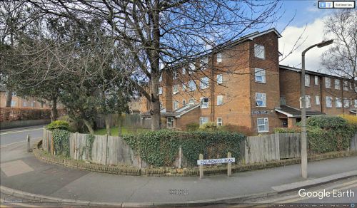
| Vicinity | Distin Court, on corner of Robin Hood Lane and Collingwood Road |
| Type | Building |
| Interest | Robin Hood name |
| Status | Defunct |
| First Record | 1871 |
Distin Court now occupies the site of Robin Hood Lodge.
By Henrik Thiil Nielsen, 2018-10-21. Revised by Henrik Thiil Nielsen, 2021-02-13.
A building named Robin Hood Lodge is shown on the corner of Robin Hood Lane and (the road that would later be named) Collingwood Road on a 6" O.S. map of the area published 1871 and based on surveying carried out in 1866-67 (see Maps below). The lodge is not included on subsequent 6" or 25" maps of the area.
Gazetteers
- Not included in Dobson, R. B., ed.; Taylor, J., ed. Rymes of Robyn Hood: an Introduction to the English Outlaw (London, 1976), pp. 315-19.
Maps
- 25" O.S. map Surrey XIII.11 (c. 1873; surveyed c. 1866-67). No copy in NLS
- 25" O.S. map Surrey XIII.11 (c. 1896; rev. c. 1895). No copy in NLS
- 25" O.S. map Surrey XIII.11 (1913; rev. 1910) (georeferenced)
- 25" O.S. map Surrey XIII.11 (1913; rev. 1910)
- 25" O.S. map Surrey XIII.11 (1935; rev. 1933-34)
- 6" O.S. map Surrey XIII (1871; surveyed 1866-67)
- 6" O.S. map Surrey XIII.SE (1898; rev. 1894-95) (georeferenced)
- 6" O.S. map Surrey XIII.SE (1898; rev. 1894-95)
- 6" O.S. map Surrey XIII.SE (1914; rev. 1910)
- 6" O.S. map Surrey XIII.SE (1937; rev. 1933-34)
- 6" O.S. map Surrey XIII.SE (1944; rev. 1938)
- 6" O.S. map Surrey XIII.SE (c. 1946; rev. 1938).
Also see

