Robin Hood Lane (Warnham): Difference between revisions
From International Robin Hood Bibliography
m (Text replacement - "ImgGalleryIntro" to "ImageGalleryIntroduction") |
mNo edit summary |
||
| Line 9: | Line 9: | ||
<!--== Sources == | <!--== Sources == | ||
* --> | * --> | ||
== Maps == | |||
* -- | * 25" map ''Sussex'' XIII.7 (''c.'' 1876; surveyed ''c.'' 1874). No copy in NLS | ||
* 25" map ''Sussex'' XIII.7 (''c.'' 1897; rev. ''c.'' 1895). No copy in NLS | |||
* [https://maps.nls.uk/geo/explore/#zoom=16&lat=51.09401&lon=-0.37113&layers=168&b=5 25" O.S. map ''Sussex'' XIII.3 (1912; rev. 1909)] (georeferenced) | |||
* [https://maps.nls.uk/view/103667995#zoom=4&lat=9976&lon=12201&layers=BT 25" O.S. map ''Sussex'' XIII.7 (1912; rev. 1909)] | |||
* [https://maps.nls.uk/view/103667992#zoom=5&lat=9858&lon=12245&layers=BT 25" O.S. map ''Sussex'' XIII.7 (1934; rev. 1932)] | |||
* [https://maps.nls.uk/view/102347544#zoom=6&lat=3794&lon=8789&layers=BT 6" O.S. map ''Surrey'' XLVII (1874; surveyed 1870–71)] | |||
* [https://maps.nls.uk/geo/explore/#zoom=16&lat=51.09402&lon=-0.36770&layers=6&b=5 6" O.S. map ''Sussex'' XIII.NE (1898; rev. 1895–96)] (georeferenced) | |||
* [https://maps.nls.uk/view/101437759#zoom=4&lat=1984&lon=6451&layers=BT 6" O.S. map ''Surrey'' XLVII.NW (1898; rev. 1895–96)] | |||
* [https://maps.nls.uk/view/101437756#zoom=4&lat=1993&lon=6660&layers=BT 6" O.S. map ''Surrey'' XLVII.NW (1920; rev. 1913).] | |||
<!--== Discussion == | <!--== Discussion == | ||
* --> | * --> | ||
Revision as of 17:02, 24 April 2022
| Locality | |
|---|---|
| Coordinate | 51.078655, -0.348434 |
| Adm. div. | Sussex |
| Vicinity | Between the A24 and Broadbridge Heath Road, southern perimeter of Rookwood Golf Course |
| Type | Thoroughfare |
| Interest | Robin Hood name |
| Status | Extant |
| First Record | |
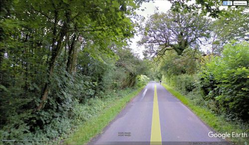
Robin Hood Lane (Warnham).
By Henrik Thiil Nielsen, 2018-01-12. Revised by Henrik Thiil Nielsen, 2022-04-24.
Robin Hood Lane in Warnham, Horsham, runs between the A24 and Broadbridge Heath Road, forming the southern perimeter of Rookwood Golf Course.
Gazetteers
- Not included in Dobson, R. B., ed.; Taylor, J., ed. Rymes of Robyn Hood: an Introduction to the English Outlaw (London, 1976), pp. 293-311.
Maps
- 25" map Sussex XIII.7 (c. 1876; surveyed c. 1874). No copy in NLS
- 25" map Sussex XIII.7 (c. 1897; rev. c. 1895). No copy in NLS
- 25" O.S. map Sussex XIII.3 (1912; rev. 1909) (georeferenced)
- 25" O.S. map Sussex XIII.7 (1912; rev. 1909)
- 25" O.S. map Sussex XIII.7 (1934; rev. 1932)
- 6" O.S. map Surrey XLVII (1874; surveyed 1870–71)
- 6" O.S. map Sussex XIII.NE (1898; rev. 1895–96) (georeferenced)
- 6" O.S. map Surrey XLVII.NW (1898; rev. 1895–96)
- 6" O.S. map Surrey XLVII.NW (1920; rev. 1913).

