Robin Hood Lane (Hatfield): Difference between revisions
From International Robin Hood Bibliography
m (Text replacement - "PnItemAlsoSee" to "PlaceNamesItemAlsoSee") |
m (Text replacement - "No Copy in NLS" to "No copy in NLS") |
||
| (One intermediate revision by the same user not shown) | |||
| Line 5: | Line 5: | ||
<p id="byline">By Henrik Thiil Nielsen, 2018-01-10. Revised by {{#realname:{{REVISIONUSER}}}}, {{REVISIONYEAR}}-{{REVISIONMONTH}}-{{REVISIONDAY2}}.</p> | <p id="byline">By Henrik Thiil Nielsen, 2018-01-10. Revised by {{#realname:{{REVISIONUSER}}}}, {{REVISIONYEAR}}-{{REVISIONMONTH}}-{{REVISIONDAY2}}.</p> | ||
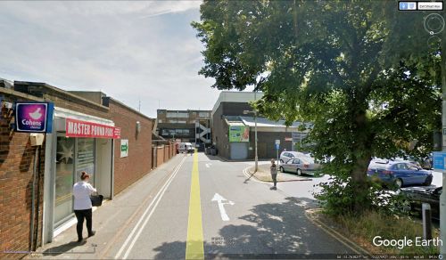
Robin Hood Lane is a short side street of the Common in Hatfield. It must have been named after the [[Robin Hood (Hatfield)|Robin Hood]] pub which was demolished ''c.'' 1971. | Robin Hood Lane is a short side street of the Common in Hatfield. It must have been named after the [[Robin Hood (Hatfield)|Robin Hood]] pub which was demolished ''c.'' 1971. | ||
{{ | {{PlaceNamesItemAllusionsAndRecords}} | ||
== Maps == | == Maps == | ||
Maps of the area. | Maps of the area. | ||
* 25" O.S. map ''Hertfordshire'' XXXV.7 (''c.'' 1878; surveyed 1878). No | * 25" O.S. map ''Hertfordshire'' XXXV.7 (''c.'' 1878; surveyed 1878). No copy in NLS | ||
* [https://maps.nls.uk/geo/explore/#zoom=17&lat=51.76400&lon=-0.22734&layers=168&b=5 25" O.S. map ''Hertfordshire'' XXXV.7 (1898; rev. 1896)] (georeferenced) | * [https://maps.nls.uk/geo/explore/#zoom=17&lat=51.76400&lon=-0.22734&layers=168&b=5 25" O.S. map ''Hertfordshire'' XXXV.7 (1898; rev. 1896)] (georeferenced) | ||
* [https://maps.nls.uk/geo/explore/#zoom=16&lat=51.76402&lon=-0.22882&layers=6&b=5 25" O.S. map ''Hertfordshire'' XXXV.7 (1898; rev. 1896)] | * [https://maps.nls.uk/geo/explore/#zoom=16&lat=51.76402&lon=-0.22882&layers=6&b=5 25" O.S. map ''Hertfordshire'' XXXV.7 (1898; rev. 1896)] | ||
Latest revision as of 01:14, 13 February 2021
| Locality | |
|---|---|
| Coordinate | 51.763937, -0.227012 |
| Adm. div. | Hertfordshire |
| Vicinity | Side street of the Common |
| Type | Thoroughfare |
| Interest | Robin Hood name |
| Status | Extant |
| First Record | |
Robin Hood Lane (Hatfield).
By Henrik Thiil Nielsen, 2018-01-10. Revised by Henrik Thiil Nielsen, 2021-02-13.
Robin Hood Lane is a short side street of the Common in Hatfield. It must have been named after the Robin Hood pub which was demolished c. 1971.
Maps
Maps of the area.
- 25" O.S. map Hertfordshire XXXV.7 (c. 1878; surveyed 1878). No copy in NLS
- 25" O.S. map Hertfordshire XXXV.7 (1898; rev. 1896) (georeferenced)
- 25" O.S. map Hertfordshire XXXV.7 (1898; rev. 1896)
- 25" O.S. map Hertfordshire XXXV.7 (1924; rev. 1922)
- 25" O.S. map Hertfordshire XXXV.7 (1945; rev. 1937)
- 6" O.S. map Hertfordshire XXXV (1883; surveyed 1873–79)
- 6" O.S. map Hertfordshire XXXV.NE (1899; rev. 1896)
- 6" O.S. map Hertfordshire XXXV.NE (1925; rev. 1922)
- 6" O.S. map Hertfordshire XXXV.NE (c. 1949; rev. 1937–39)
- 6" O.S. map Hertfordshire XXXV.NE (1899; rev. 1896) (georeferenced).
Gazetteers
- Not included in Dobson, R. B., ed.; Taylor, J., ed. Rymes of Robyn Hood: an Introduction to the English Outlaw (London, 1976), pp. 293-311.
Background
Also see

