
Robin Hood Lane (Hall Green)
From International Robin Hood Bibliography
| Locality | |
|---|---|
| Coordinate | 52.426535, -1.850741 |
| Adm. div. | Worcestershire |
| Vicinity | Between Cole Valley Road/Sarehold Road and Stratford Road |
| Type | Thoroughfare |
| Interest | Robin Hood name |
| Status | Extant |
| First Record | |
Robin Hood Lane (Hall Green).

By Henrik Thiil Nielsen, 2018-01-12. Revised by Henrik Thiil Nielsen, 2021-01-06.
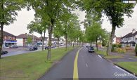
Robin Hood Lane is a major street in Hall Green, connecting Cole Valley Road/Sarehold Road and Stratford Road.
Gazetteers
- Not included in Dobson, R. B., ed.; Taylor, J., ed. Rymes of Robyn Hood: an Introduction to the English Outlaw (London, 1976), pp. 293-311.
Also see
Robin Hood Lane, Hall Green / Google Earth Street View.
