
Robin Hood Lane (Hall Green): Difference between revisions
From International Robin Hood Bibliography
m (Text replacement - "PnItemNav" to "PlaceNamesItemNavigation") |
m (Text replacement - "PnItemAlsoSee" to "PlaceNamesItemAlsoSee") |
||
| Line 7: | Line 7: | ||
== Gazetteers == | == Gazetteers == | ||
* Not included in {{:Dobson, Richard Barrie 1976a}}, pp. 293-311. | * Not included in {{:Dobson, Richard Barrie 1976a}}, pp. 293-311. | ||
{{ | {{PlaceNamesItemAlsoSee}} | ||
</div> | </div> | ||
Revision as of 00:42, 6 January 2021
| Locality | |
|---|---|
| Coordinate | 52.426535, -1.850741 |
| Adm. div. | Worcestershire |
| Vicinity | Between Cole Valley Road/Sarehold Road and Stratford Road |
| Type | Thoroughfare |
| Interest | Robin Hood name |
| Status | Extant |
| First Record | |
Robin Hood Lane (Hall Green).

By Henrik Thiil Nielsen, 2018-01-12. Revised by Henrik Thiil Nielsen, 2021-01-06.
Robin Hood Lane is a major street in Hall Green, connecting Cole Valley Road/Sarehold Road and Stratford Road.Template:PlaceNamesItemQuery
Gazetteers
- Not included in Dobson, R. B., ed.; Taylor, J., ed. Rymes of Robyn Hood: an Introduction to the English Outlaw (London, 1976), pp. 293-311.
Also see
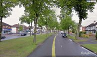
Robin Hood Lane, Hall Green / Google Earth Street View.
