
Robin Hood Lane (Bristol): Difference between revisions
mNo edit summary |
m (Text replacement - "ImgGalleryIntro" to "ImageGalleryIntroduction") |
||
| (28 intermediate revisions by 2 users not shown) | |||
| Line 1: | Line 1: | ||
__NOTOC__{{ | __NOTOC__{{PlaceNamesItemTop|Lat=51.458714|Lon=-2.598962|AdministrativeDivision=Gloucestershire|Vicinity=From St Michael's Hill (immediately N of No. 56) to Horfield Road in Bristol|Type=Thoroughfare|Interest=Robin Hood name|Status=Extant|Demonym=|Riding=|GreaterLondon=|Year=1824|Aka=Robinhood Lane|Century=18|Cluster1=St Michael's Hill (Bristol)|Cluster2=Bristol|Cluster3=|Image=geograph-4853111-by-Derek-Harper.jpg|Postcards=|ExtraCat1=Robinhood place-names|ExtraCat2=|ExtraCat3=|ExtraCat4=|ExtraCat5=|ExtraLink1=|ExtraLink2=|ExtraLink3=|ExtraLink4=|ExtraLink5=|ExtraLinkName1=|ExtraLinkName2=|ExtraLinkName3=|ExtraLinkName4=|ExtraLinkName5=|GeopointPrefix=|GeopointSuffix=|StatusSuffix=|DatePrefix=|DateSuffix=}} | ||
{{#display_map:{{#var:Coords}}~{{#replace:{{PAGENAME}}|'|'}}|width=34%}}<div class="pnMapLegend">The Robin Hood.</div> | {{#display_map:{{#var:Coords}}~{{#replace:{{PAGENAME}}|'|'}}|width=34%|enablefullscreen=yes}}<div class="pnMapLegend">The Robin Hood.</div> | ||
[[File:{{#var: | [[File:{{#var:Image}}|thumb|right|350px|Robin Hood Lane, Bristol, alley off St Michael's Hill / [http://www.geograph.org.uk/photo/4853111 Derek Harper, 1 Mar. 2016; Creative Commons, via Geograph.]]]<div class="no-img"> | ||
<p id="byline">By Henrik Thiil Nielsen, | <p id="byline">By Henrik Thiil Nielsen, 2018-10-16. Revised by {{#realname:{{REVISIONUSER}}}}, {{REVISIONYEAR}}-{{REVISIONMONTH}}-{{REVISIONDAY2}}.</p>Robin Hood Lane is a footpath from St Michael's Hill (immediately north of No. 56) to Horfield Road in Bristol. The name would seem to be of 18th century date if not older. The earliest record so far found dates from 1824.<ref>{{:Evans, John 1824a}}, pp. xxii, xxiii.</ref> | ||
56 St Michael's Hill is the address of the [[Robin Hood (St Michael's Hill, Bristol)|Robin Hood]], a pub which first appears in the records in 1848 but cannot be older than 1841, at which time there was a carpenter's shop there. Before that the building was home to a grocer's shop. According to a website on lost pubs in Bristol – the source of the information just cited – "[t]he name [of the Robin Hood pub] is taken from Robin Hood Lane which runs down the side of the pub and was in existence long before this house became licensed".<ref>[http://bristolslostpubs.eu/page190.html Bristol's Lost Pubs.]</ref> While this is possible, it is hardly the whole story. Just after the still existing Robin Hood pub, the same website lists a public house named 'Robin Hood and Little John', also located on St Michael's Hill, in existence at least until 1782. This, I would suggest, in all probability provided the inspiration for the name 'Robin Hood Lane', and if it closed in or shortly after 1782, the span of years from then to 1848 is not so long that the existence of this older Robin Hood pub would have been forgotten locally. It is my impression that public houses are much more likely to give rise to other Robin Hood names in their vicinity than to be named after them. Pubs tended to be social hubs, and like other businesses they had conspicuous signs. These facts together explain why pub names were often, as it were, contagious. Until the name of the lane can be shown to substantially predate that of the older of the two Robin Hood pubs, the assumption must be that the latter was the source of the other names. 'Robin Hood Lane' would therefore have originated as the name of the lane where the 18th century Robin Hood pub was located. | |||
The lane is shown on most of the maps listed below but only labelled – as 'Robinhood Lane' – on the 25" map published in 1896, based on a survey done in 1881-82. | |||
== Gazetteers == | == Gazetteers == | ||
* Not included in {{:Dobson, Richard Barrie 1976a}}, pp. 315-19. | * Not included in {{:Dobson, Richard Barrie 1976a}}, pp. 315-19. | ||
== Sources == | == Sources == | ||
* [http://bristolslostpubs.eu/page190.html Bristol's Lost Pubs] | * [http://bristolslostpubs.eu/page190.html Bristol's Lost Pubs] | ||
* | * {{:Evans, John 1824a}}, pp. xxii, xxiii. | ||
== Maps == | == Maps == | ||
* [https://maps.nls.uk/view/109729702#zoom=5&lat=4836&lon=10824&layers=BT 25" O.S. map ''Gloucestershire'' LXXI.16 (1885; surveyed 1880-82)] | * [https://maps.nls.uk/view/109729702#zoom=5&lat=4836&lon=10824&layers=BT 25" O.S. map ''Gloucestershire'' LXXI.16 (1885; surveyed 1880-82)] | ||
| Line 47: | Line 35: | ||
* [https://maps.nls.uk/view/101454555#zoom=6&lat=2244&lon=6921&layers=BT 6" O.S. map ''Gloucestershire'' LXXI.SE (''c.'' 1946; rev. 1938)] | * [https://maps.nls.uk/view/101454555#zoom=6&lat=2244&lon=6921&layers=BT 6" O.S. map ''Gloucestershire'' LXXI.SE (''c.'' 1946; rev. 1938)] | ||
* [https://maps.nls.uk/view/101724802#zoom=5&lat=5929&lon=7696&layers=BT 6" O.S. map ''Somerset'' VI.NW (''c.'' 1947; rev. 1938).] | * [https://maps.nls.uk/view/101724802#zoom=5&lat=5929&lon=7696&layers=BT 6" O.S. map ''Somerset'' VI.NW (''c.'' 1947; rev. 1938).] | ||
{{ | {{PlaceNamesItemAlsoSee}} | ||
== Notes == | == Notes == | ||
<references/> | <references/> | ||
</div> | |||
< | <div id="gallery"> | ||
{{ | {{ImageGalleryIntroduction}} | ||
<gallery widths="195px"> | <gallery widths="195px"> | ||
geograph-4853111-by-Derek-Harper.jpg|Robin Hood Lane, Bristol, alley off St Michael's Hill / [http://www.geograph.org.uk/photo/4853111 Derek Harper, 1 Mar. 2016; Creative Commons via Geograph.] | geograph-4853111-by-Derek-Harper.jpg|Robin Hood Lane, Bristol, alley off St Michael's Hill / [http://www.geograph.org.uk/photo/4853111 Derek Harper, 1 Mar. 2016; Creative Commons, via Geograph.] | ||
robin-hood-lane-st-michaels-hill-bristol-1-google-earth-street-view.jpg|Peeping into Robin Hood Lane from St Michael's Hill, immediately north of the Robin Hood / Google Earth Street View. | robin-hood-lane-st-michaels-hill-bristol-1-google-earth-street-view.jpg|Peeping into Robin Hood Lane from St Michael's Hill, immediately north of the Robin Hood / Google Earth Street View. | ||
robin-hood-lane-st-michaels-hill-bristol-2-google-earth-street-view.jpg|Peeping into Robin Hood Lane from Horfield Road / Google Earth Street View. | robin-hood-lane-st-michaels-hill-bristol-2-google-earth-street-view.jpg|Peeping into Robin Hood Lane from Horfield Road / Google Earth Street View. | ||
</gallery> | </gallery> | ||
</div> | |||
{{PlaceNamesItemNavigation}} | |||
{{ | |||
Latest revision as of 13:53, 7 January 2021
| Locality | |
|---|---|
| Coordinate | 51.458714, -2.598962 |
| Adm. div. | Gloucestershire |
| Vicinity | From St Michael's Hill (immediately N of No. 56) to Horfield Road in Bristol |
| Type | Thoroughfare |
| Interest | Robin Hood name |
| Status | Extant |
| First Record | 1824 |
| A.k.a. | Robinhood Lane |

By Henrik Thiil Nielsen, 2018-10-16. Revised by Henrik Thiil Nielsen, 2021-01-07.
Robin Hood Lane is a footpath from St Michael's Hill (immediately north of No. 56) to Horfield Road in Bristol. The name would seem to be of 18th century date if not older. The earliest record so far found dates from 1824.[1]
56 St Michael's Hill is the address of the Robin Hood, a pub which first appears in the records in 1848 but cannot be older than 1841, at which time there was a carpenter's shop there. Before that the building was home to a grocer's shop. According to a website on lost pubs in Bristol – the source of the information just cited – "[t]he name [of the Robin Hood pub] is taken from Robin Hood Lane which runs down the side of the pub and was in existence long before this house became licensed".[2] While this is possible, it is hardly the whole story. Just after the still existing Robin Hood pub, the same website lists a public house named 'Robin Hood and Little John', also located on St Michael's Hill, in existence at least until 1782. This, I would suggest, in all probability provided the inspiration for the name 'Robin Hood Lane', and if it closed in or shortly after 1782, the span of years from then to 1848 is not so long that the existence of this older Robin Hood pub would have been forgotten locally. It is my impression that public houses are much more likely to give rise to other Robin Hood names in their vicinity than to be named after them. Pubs tended to be social hubs, and like other businesses they had conspicuous signs. These facts together explain why pub names were often, as it were, contagious. Until the name of the lane can be shown to substantially predate that of the older of the two Robin Hood pubs, the assumption must be that the latter was the source of the other names. 'Robin Hood Lane' would therefore have originated as the name of the lane where the 18th century Robin Hood pub was located.
The lane is shown on most of the maps listed below but only labelled – as 'Robinhood Lane' – on the 25" map published in 1896, based on a survey done in 1881-82.
Gazetteers
- Not included in Dobson, R. B., ed.; Taylor, J., ed. Rymes of Robyn Hood: an Introduction to the English Outlaw (London, 1976), pp. 315-19.
Sources
- Bristol's Lost Pubs
- Evans, John, compil. A Chronological Outline of the History of Bristol, and the Stranger's Guide through its Street and Neighbourhood ([Bristol], 1824), pp. xxii, xxiii.
Maps
- 25" O.S. map Gloucestershire LXXI.16 (1885; surveyed 1880-82)
- 25" O.S. map Somerset VI.2 (1896; surveyed 1881-82)
- 25" O.S. map Gloucestershire LXXI.16 (1903; rev. 1901) (georeferenced)
- 25" O.S. map Gloucestershire LXXI.16 (1903; rev. 1901)
- 25" O.S. map Somerset VI.2 (1904; rev. 1901-1902)
- 25" O.S. map Gloucestershire LXXI.16 (1918; rev. 1913)
- 6" O.S. map Gloucestershire LXXI.SE (1888; surveyed 1880-83)
- 6" O.S. map Gloucestershire LXXI.SE (1904; rev. 1901-1902)
- 6" O.S. map Somerset VI.NW (1905; rev. 1901-1902) (georeferenced)
- 6" O.S. map Somerset VI.NW (1905; rev. 1901-1902)
- 6" O.S. map Gloucestershire LXXI (1921; rev. 1912-13)
- 6" O.S. map Gloucestershire LXXI.SE (1921; rev. 1912-13)
- 6" O.S. map Somerset VI (1921; rev. 1912-13)
- 6" O.S. map Somerset VI.NW (1921; rev. 1913)
- 6" O.S. map Somerset VI.NW (1933; rev. 1930)
- 6" O.S. map Gloucestershire LXXI.SE (c. 1944; rev. 1938)
- 6" O.S. map Somerset VI.NW (c. 1945; rev. 1938)
- 6" O.S. map Gloucestershire LXXI.SE (c. 1946; rev. 1938)
- 6" O.S. map Somerset VI.NW (c. 1947; rev. 1938).
Also see
Notes
Image gallery
Click any image to display it in the lightbox, where you can navigate between images by clicking in the right or left side of the current image.
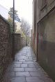
Robin Hood Lane, Bristol, alley off St Michael's Hill / Derek Harper, 1 Mar. 2016; Creative Commons, via Geograph.
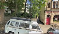
Peeping into Robin Hood Lane from St Michael's Hill, immediately north of the Robin Hood / Google Earth Street View.
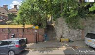
Peeping into Robin Hood Lane from Horfield Road / Google Earth Street View.

