
Robin Hood Lane (Bristol): Difference between revisions
mNo edit summary |
mNo edit summary |
||
| Line 1: | Line 1: | ||
__NOTOC__{{PnItemTop|Lat=51.458714|Lon=-2.598962|AdmDiv=Gloucestershire|Vicinity=From St Michael's Hill (immediately N of No. 56) to Horfield Road in Bristol|Type=Thoroughfare|Interest=Robin Hood name|Status=Extant|Demonym=|Riding=|GreaterLondon=|Year=|Aka=|Century=18|Cluster1=St Michael's Hill (Bristol)|Cluster2=|Cluster3=|Image=geograph-4853111-by-Derek-Harper.jpg|Postcards=|ExtraCat1=|ExtraCat2=|ExtraCat3=|ExtraCat4=|ExtraCat5=|ExtraLink1=|ExtraLink2=|ExtraLink3=|ExtraLink4=|ExtraLink5=|ExtraLinkName1=|ExtraLinkName2=|ExtraLinkName3=|ExtraLinkName4=|ExtraLinkName5=|GeopointPrefix=|GeopointSuffix=|StatusSuffix=|DatePrefix=|DateSuffix=}} | __NOTOC__{{PnItemTop|Lat=51.458714|Lon=-2.598962|AdmDiv=Gloucestershire|Vicinity=From St Michael's Hill (immediately N of No. 56) to Horfield Road in Bristol|Type=Thoroughfare|Interest=Robin Hood name|Status=Extant|Demonym=|Riding=|GreaterLondon=|Year=|Aka=|Century=18|Cluster1=St Michael's Hill (Bristol)|Cluster2=|Cluster3=|Image=geograph-4853111-by-Derek-Harper.jpg|Postcards=|ExtraCat1=|ExtraCat2=|ExtraCat3=|ExtraCat4=|ExtraCat5=|ExtraLink1=|ExtraLink2=|ExtraLink3=|ExtraLink4=|ExtraLink5=|ExtraLinkName1=|ExtraLinkName2=|ExtraLinkName3=|ExtraLinkName4=|ExtraLinkName5=|GeopointPrefix=|GeopointSuffix=|StatusSuffix=|DatePrefix=|DateSuffix=}} | ||
{{#display_map:{{#var:Coords}}~{{#replace:{{PAGENAME}}|'|'}}|width=34%}}<div class="pnMapLegend">The Robin Hood.</div> | {{#display_map:{{#var:Coords}}~{{#replace:{{PAGENAME}}|'|'}}|width=34%}}<div class="pnMapLegend">The Robin Hood.</div> | ||
[[File:{{#var:Pnimage}}|thumb|right|350px| | [[File:{{#var:Pnimage}}|thumb|right|350px|Robin Hood Lane, Bristol, alley off St Michael's Hill / [http://www.geograph.org.uk/photo/4853111 Derek Harper, 1 Mar. 2016; Creative Commons via Geograph.]]] | ||
<p id="byline">By Henrik Thiil Nielsen, 2013-08-07. Revised by {{#realname:{{REVISIONUSER}}}}, {{REVISIONYEAR}}-{{REVISIONMONTH}}-{{REVISIONDAY2}}.</p> | <p id="byline">By Henrik Thiil Nielsen, 2013-08-07. Revised by {{#realname:{{REVISIONUSER}}}}, {{REVISIONYEAR}}-{{REVISIONMONTH}}-{{REVISIONDAY2}}.</p> | ||
<div class="no-img">The present Robin Hood at 56 St Michael's Hill in Bristol was in existence by 1848. Immediately north of the pub is [[Robin Hood Lane (Bristol)|Robin Hood Lane]] which connects St Michael's Hill and Horfield Road. | <div class="no-img">The present Robin Hood at 56 St Michael's Hill in Bristol was in existence by 1848. Immediately north of the pub is [[Robin Hood Lane (Bristol)|Robin Hood Lane]] which connects St Michael's Hill and Horfield Road. | ||
Revision as of 17:09, 16 October 2018
[[File:|thumb|right|350px|Robin Hood Lane, Bristol, alley off St Michael's Hill / Derek Harper, 1 Mar. 2016; Creative Commons via Geograph.]]
By Henrik Thiil Nielsen, 2013-08-07. Revised by Henrik Thiil Nielsen, 2018-10-16.
The following past proprietors are known:
- 1848-49 – John Gerrish
- 1851 – James White
- 1853-55 – Thomas Davis Jarrett
- 1856 – Joseph Pittaway
- 1860-65 – Thomas Shipp
- 1866-1874 – Hannah Shipp
- 1875-79 – Thomas Ridler
- 1881-1904 – Matilda Ridler
- 1906 – Lydia Wride
- 1914-40 – James Callaway
- 1940 – Nellie Callaway
- 1944-75 – Lionel W. Hamblett.[1]
It is not known if John Gerrish (1848-49) was the first publican, but there cannot have been many in the years immediately before his tenure, for in 1841 the building was home to a carpentry and before that to a grocer's shop. However, there was also a Robin Hood pub on St Michael's Hill during the years 1752 to 82. Most likely this was located either at the same site, perhaps in the same building, or immediately north of Robin Hood Lane. See further Robin Hood (St Michael's Hill, Bristol) (1).Template:PnItemQry
Gazetteers
- Not included in Dobson, R. B., ed.; Taylor, J., ed. Rymes of Robyn Hood: an Introduction to the English Outlaw (London, 1976), pp. 315-19.
Sources
Maps
- 25" O.S. map Gloucestershire LXXI.16 (1885; surveyed 1880-82)
- 25" O.S. map Somerset VI.2 (1896; surveyed 1881-82)
- 25" O.S. map Gloucestershire LXXI.16 (1903; rev. 1901) (georeferenced)
- 25" O.S. map Gloucestershire LXXI.16 (1903; rev. 1901)
- 25" O.S. map Somerset VI.2 (1904; rev. 1901-1902)
- 25" O.S. map Gloucestershire LXXI.16 (1918; rev. 1913)
- 6" O.S. map Gloucestershire LXXI.SE (1888; surveyed 1880-83)
- 6" O.S. map Gloucestershire LXXI.SE (1904; rev. 1901-1902)
- 6" O.S. map Somerset VI.NW (1905; rev. 1901-1902) (georeferenced)
- 6" O.S. map Somerset VI.NW (1905; rev. 1901-1902)
- 6" O.S. map Gloucestershire LXXI (1921; rev. 1912-13)
- 6" O.S. map Gloucestershire LXXI.SE (1921; rev. 1912-13)
- 6" O.S. map Somerset VI (1921; rev. 1912-13)
- 6" O.S. map Somerset VI.NW (1921; rev. 1913)
- 6" O.S. map Somerset VI.NW (1933; rev. 1930)
- 6" O.S. map Gloucestershire LXXI.SE (c. 1944; rev. 1938)
- 6" O.S. map Somerset VI.NW (c. 1945; rev. 1938)
- 6" O.S. map Gloucestershire LXXI.SE (c. 1946; rev. 1938)
- 6" O.S. map Somerset VI.NW (c. 1947; rev. 1938).
Notes
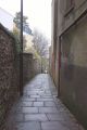
Robin Hood Lane, Bristol, alley off St Michael's Hill / Derek Harper, 1 Mar. 2016; Creative Commons via Geograph.
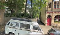
Peeping into Robin Hood Lane from St Michael's Hill, immediately north of the Robin Hood / Google Earth Street View.
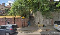
Peeping into Robin Hood Lane from Horfield Road / Google Earth Street View.


